
Hedges at Hawthorne
204 Wagaraw Rd,
Hawthorne, NJ 07506
$2,599 - $3,295
Studio - 2 Beds
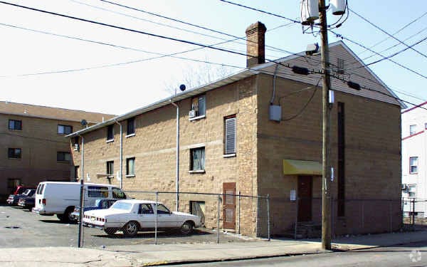
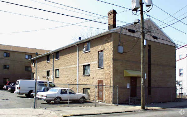
At 24 Units in Paterson, experience fine living. Located at 112-116 E. 16th Ave in Paterson, this community is an ideal place to live. Come by to check out the apartment floorplan options. The leasing team is waiting to show you all that this community has to offer. Stop by the leasing office to check the current floorplan availability.
24 Units is an apartment community located in Passaic County and the 07501 ZIP Code. This area is served by the Paterson Public School District attendance zone.
Eastside is a suburban Paterson neighborhood about 20 miles away from New York City. Eastside’s southern border rests on Interstate 80 while its eastern border is situated along the Passaic River, ensuring residents have access to outdoor fun and easy travel. Favorite parks within the neighborhood include the picturesque Eastside Park along with Roberto Clemente Park. Family-friendly eateries like pizzerias and ice cream shops dot the area as well. Service stores and grocers can be found in the area, but residents can travel to Center City Mall, located in the heart of Downtown Paterson, for other retail needs. Downtown Paterson is minutes away from Eastside and is home to several specialty shops and local restaurants and bars.
Eastside’s rental options consist of apartments with a few houses and condos available in brick front buildings, row homes, and more.
Learn more about living in EastsideCompare neighborhood and city base rent averages by bedroom.
| Eastside | Paterson, NJ | |
|---|---|---|
| Studio | $1,202 | $1,175 |
| 1 Bedroom | $1,439 | $1,451 |
| 2 Bedrooms | $1,571 | $1,927 |
| 3 Bedrooms | $1,676 | $2,142 |
| Colleges & Universities | Distance | ||
|---|---|---|---|
| Colleges & Universities | Distance | ||
| Walk: | 8 min | 0.4 mi | |
| Drive: | 6 min | 2.4 mi | |
| Drive: | 8 min | 3.7 mi | |
| Drive: | 9 min | 5.1 mi |


Transportation options available in Paterson include Grove Street, located 10.9 miles from 24 Units. 24 Units is near Newark Liberty International, located 21.5 miles or 26 minutes away, and LaGuardia, located 24.6 miles or 37 minutes away.
| Transit / Subway | Distance | ||
|---|---|---|---|
| Transit / Subway | Distance | ||
|
|
Drive: | 16 min | 10.9 mi |
|
|
Drive: | 17 min | 11.2 mi |
|
|
Drive: | 17 min | 11.4 mi |
|
|
Drive: | 18 min | 11.7 mi |
| Commuter Rail | Distance | ||
|---|---|---|---|
| Commuter Rail | Distance | ||
|
|
Walk: | 6 min | 0.3 mi |
|
|
Drive: | 5 min | 2.8 mi |
|
|
Drive: | 6 min | 3.0 mi |
|
|
Drive: | 8 min | 4.1 mi |
|
|
Drive: | 8 min | 5.1 mi |
| Airports | Distance | ||
|---|---|---|---|
| Airports | Distance | ||
|
Newark Liberty International
|
Drive: | 26 min | 21.5 mi |
|
LaGuardia
|
Drive: | 37 min | 24.6 mi |
Scores provided by
Traffic
-Airport
-Businesses
-Scores provided by
HowLoud What is a Sound Score Rating? A Sound Score Rating aggregates noise caused by vehicle traffic, airplane traffic and local sources. How It WorksTime and distance from 24 Units.
| Shopping Centers | Distance | ||
|---|---|---|---|
| Shopping Centers | Distance | ||
| Drive: | 2 min | 1.2 mi | |
| Drive: | 4 min | 2.3 mi |
| Parks and Recreation | Distance | ||
|---|---|---|---|
| Parks and Recreation | Distance | ||
|
Rifle Camp Park Observatory
|
Drive: | 6 min | 3.3 mi |
|
Presby Memorial Iris Gardens
|
Drive: | 10 min | 6.1 mi |
|
NJ Audubon Lorrimer Sanctuary
|
Drive: | 11 min | 6.4 mi |
|
Bergen County Zoo
|
Drive: | 13 min | 7.9 mi |
|
Saddle River County Park
|
Drive: | 17 min | 8.4 mi |
| Hospitals | Distance | ||
|---|---|---|---|
| Hospitals | Distance | ||
| Drive: | 2 min | 1.2 mi | |
| Drive: | 9 min | 5.4 mi | |
| Drive: | 9 min | 5.5 mi |
| Military Bases | Distance | ||
|---|---|---|---|
| Military Bases | Distance | ||
| Drive: | 35 min | 23.8 mi | |
| Drive: | 33 min | 24.1 mi | |
| Drive: | 48 min | 32.1 mi |
What Are Walk Score®, Transit Score®, and Bike Score® Ratings?
Walk Score® measures the walkability of any address. Transit Score® measures access to public transit. Bike Score® measures the bikeability of any address.
What is a Sound Score Rating?
A Sound Score Rating aggregates noise caused by vehicle traffic, airplane traffic and local sources.
112-116 E 16th Ave
Paterson, NJ 07501


