
$4,950
Total Monthly Price
24 Tyrella Ct
Mountain View, CA 94043
Favorites
24 Tyrella Ct

Favorites
Check Back Soon for Upcoming Availability
| Beds | Baths | Average SF |
|---|---|---|
| 4 Bedrooms 4 Bedrooms 4 Br | 2 Baths 2 Baths 2 Ba | 1,525 SF |
Fees and Policies
The fees listed below are community-provided and may exclude utilities or add-ons. All payments are made directly to the property and are non-refundable unless otherwise specified.
- Dogs Allowed
-
Fees not specified
- Cats Allowed
-
Fees not specified
- Parking
-
Garage--
About This Property
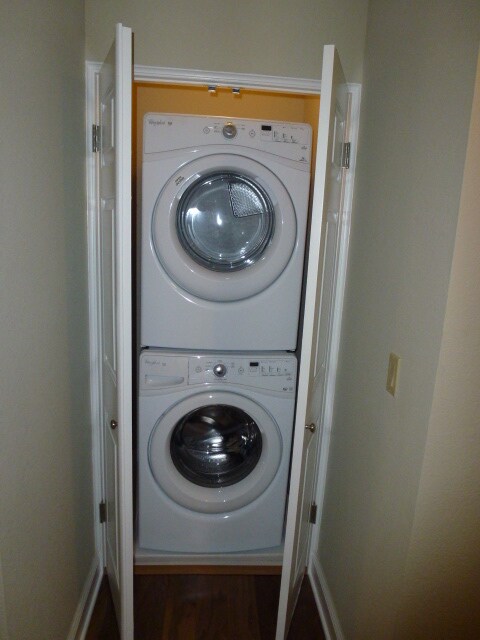
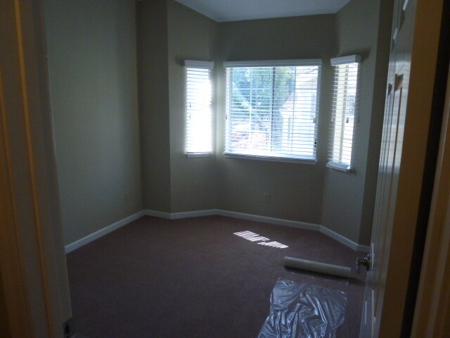
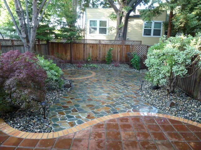
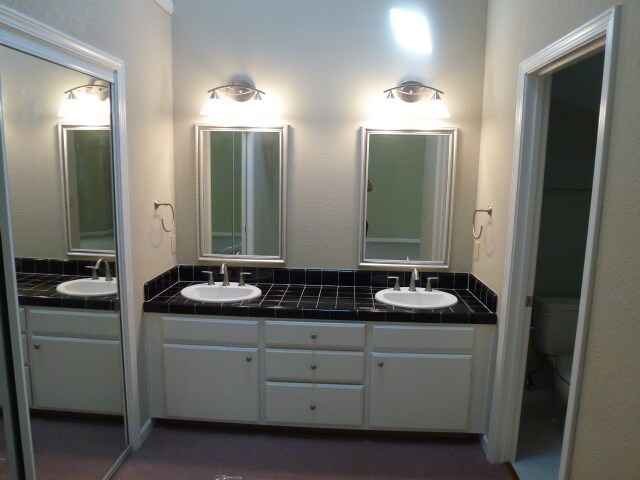
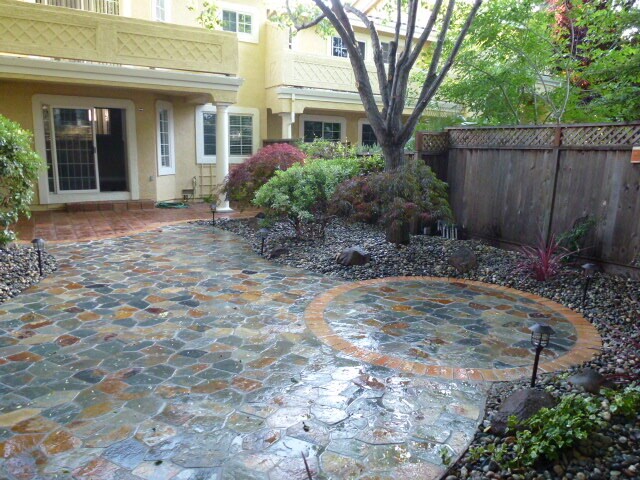
3 beds + large space for Office or 4th bedroom | 2 Full baths ##AVAILABLE Aug 15, 2021## 1525 sqft. Living space / 2880 sqft. lot size. Masterfully expressed modern Mediterranean style town home, elegant entry to newly remodeled living room with fireplace, crown molding, hardwood floors, remodeled master bedroom with bed room carpet, remodeled bath rooms, remodeled Gourmet kitchen with SS appliances with granite counter top with under cabinet lighting , washer & dryer, Double pane windows, recessed lights, wooden high end blinds, beautifully remodeled backyard with large patio for great entertainment and BBQ with Santa Barbara Gold Meshed Natural Stone Slate Flagstone. Excellent 10/10 Huff Elementary and Mountain View - Los Altos High school district. close to major tech companies, LinkedIn, public transportation and Hetch Hetchy trail around the corner.
24 Tyrella Ct is a townhome located in Santa Clara County and the 94043 ZIP Code.
Townhome Features
Washer/Dryer
Air Conditioning
Dishwasher
Hardwood Floors
- Washer/Dryer
- Air Conditioning
- Smoke Free
- Fireplace
- Dishwasher
- Granite Countertops
- Stainless Steel Appliances
- Kitchen
- Hardwood Floors
- Carpet
- Office
- Crown Molding
- Double Pane Windows
- Patio
24 Tyrella Ct,
Mountain View,
CA
94043
Known for its fantastic views of the Santa Cruz Mountains, the Wagon Wheel neighborhood of Mountain View, California lies 12 miles southeast of Palo Alto via US-101S. Residents of Wagon Wheel's apartments and home rentals enjoy convenient transportation via light rail, bus, and private shuttle. Featuring an online chat group, this community values resident participation in planning activities such as ice cream socials, community breakfasts, and pumpkin festivals at the local park.
Two parks serve this neighborhood where residents can picnic, relax in an arbor, or join a pick-up baseball game. Whisman Park provides access to the Stevens Creek Trail, with its paved paths for walking, biking, or jogging through scenic natural areas.
Learn more about living in Wagon WheelBelow are rent ranges for similar nearby apartments
Amenities
- Washer/Dryer
- Air Conditioning
- Smoke Free
- Fireplace
- Dishwasher
- Granite Countertops
- Stainless Steel Appliances
- Kitchen
- Hardwood Floors
- Carpet
- Office
- Crown Molding
- Double Pane Windows
- Patio
Education
| Colleges & Universities | Distance | ||
|---|---|---|---|
| Colleges & Universities | Distance | ||
| Drive: | 8 min | 3.2 mi | |
| Drive: | 15 min | 5.9 mi | |
| Drive: | 17 min | 7.2 mi | |
| Drive: | 12 min | 7.5 mi |
24 Tyrella Ct is within 8 minutes or 3.2 miles from Foothill College, Middlefield. It is also near Foothill Coll., Los Altos and De Anza College.
Transportation options available in Mountain View include Whisman Station, located 1.0 miles from 24 Tyrella Ct. 24 Tyrella Ct is near Norman Y Mineta San Jose International, located 8.8 miles or 14 minutes away, and San Francisco International, located 25.4 miles or 33 minutes away.
| Transit / Subway | Distance | ||
|---|---|---|---|
| Transit / Subway | Distance | ||
|
|
Walk: | 20 min | 1.0 mi |
|
|
Drive: | 3 min | 1.2 mi |
| Drive: | 3 min | 1.2 mi | |
| Drive: | 3 min | 1.2 mi | |
| Drive: | 5 min | 2.2 mi |
| Commuter Rail | Distance | ||
|---|---|---|---|
| Commuter Rail | Distance | ||
| Drive: | 6 min | 2.3 mi | |
| Drive: | 8 min | 3.0 mi | |
| Drive: | 8 min | 3.5 mi | |
| Drive: | 10 min | 5.7 mi | |
| Drive: | 13 min | 6.0 mi |
| Airports | Distance | ||
|---|---|---|---|
| Airports | Distance | ||
|
Norman Y Mineta San Jose International
|
Drive: | 14 min | 8.8 mi |
|
San Francisco International
|
Drive: | 33 min | 25.4 mi |
Walkability Near 24 Tyrella Ct Mountain View, CA 94043
Getting Around
 What do Walkability, Transit, Drivability, and Bikeability mean?
Walkability measures the walking distance to day-to-day needs.
Transit measures access to public transportation.
Drivability measures congestion, parking availability, and access to major roads.
Bikeability measures the suitability for cycling.
How It Works
What do Walkability, Transit, Drivability, and Bikeability mean?
Walkability measures the walking distance to day-to-day needs.
Transit measures access to public transportation.
Drivability measures congestion, parking availability, and access to major roads.
Bikeability measures the suitability for cycling.
How It Works
Fairly Walkable
Walkability
40
/ 100
Some Public Transit
Transit
40
/ 100
Exceptionally Drivable
Drivability
90
/ 100
Very Bikeable
Bikeability
80
/ 100
Scores provided by
-
Soundscore™
-
/ 100
Traffic
-Airport
-Businesses
-Scores provided by
HowLoud What is a Sound Score Rating? A Sound Score Rating aggregates noise caused by vehicle traffic, airplane traffic and local sources. How It WorksTime and distance from 24 Tyrella Ct.
| Shopping Centers | Distance | ||
|---|---|---|---|
| Shopping Centers | Distance | ||
| Walk: | 18 min | 1.0 mi | |
| Drive: | 4 min | 1.5 mi | |
| Drive: | 5 min | 2.3 mi |
24 Tyrella Ct has 3 shopping centers within 2.3 miles, which is about a 5-minute drive. The miles and minutes will be for the farthest away property.
| Parks and Recreation | Distance | ||
|---|---|---|---|
| Parks and Recreation | Distance | ||
|
Stevens Creek Shoreline Nature Study Area
|
Drive: | 9 min | 3.3 mi |
|
J. Pearce Mitchell Park
|
Drive: | 11 min | 4.0 mi |
|
Terman Park
|
Drive: | 11 min | 4.9 mi |
|
Sunnyvale Baylands Park
|
Drive: | 11 min | 5.1 mi |
|
Redwood Grove
|
Drive: | 14 min | 5.3 mi |
24 Tyrella Ct has 5 parks within 5.3 miles, including Stevens Creek Shoreline Nature Study Area, J. Pearce Mitchell Park, and Terman Park.
| Hospitals | Distance | ||
|---|---|---|---|
| Hospitals | Distance | ||
| Drive: | 6 min | 2.9 mi | |
| Drive: | 13 min | 8.0 mi | |
| Drive: | 14 min | 8.2 mi |
24 Tyrella Ct has 3 hospitals within 8.2 miles, the nearest is El Camino Hospital which is 2.9 miles away and a 6 minute drive.
| Military Bases | Distance | ||
|---|---|---|---|
| Military Bases | Distance | ||
| Drive: | 7 min | 2.0 mi | |
| Drive: | 58 min | 41.6 mi | |
| Drive: | 58 min | 41.8 mi |
24 Tyrella Ct has 3 military bases within 41.8 miles, the nearest is Ames Research Center which is 2.0 miles away and a 7 minute drive.
Similar Rentals Nearby
-
-

-

-

-
 Townhome for Rent4 Beds | 2.5 Baths | 1,474 sq ft
 -

What Are Walk Score®, Transit Score®, and Bike Score® Ratings?
Walk Score® measures the walkability of any address. Transit Score® measures access to public transit. Bike Score® measures the bikeability of any address.
What is a Sound Score Rating?
A Sound Score Rating aggregates noise caused by vehicle traffic, airplane traffic and local sources.

24 Tyrella Ct
Mountain View, CA 94043