
$879
Total Monthly Price
237 Mallow Hill Rd Unit 237 Mallow Hill Rd
Baltimore, MD 21229
2 Weeks Ago
|
Edit
Favorites
237 Mallow Hill Rd Unit 237 Mallow Hill Rd

Favorites
Check Back Soon for Upcoming Availability
| Beds | Baths | Average SF |
|---|---|---|
| 1 Bedroom 1 Bedroom 1 Br | 1 Bath 1 Bath 1 Ba | 600 SF |
Fees and Policies
The fees listed below are community-provided and may exclude utilities or add-ons. All payments are made directly to the property and are non-refundable unless otherwise specified.
- Cats Allowed
-
Fees not specified
-
Weight limit--
-
Pet Limit--
- Parking
-
Other--
Details
Utilities Included
-
Gas
-
Water
-
Sewer
Property Information
-
3 units
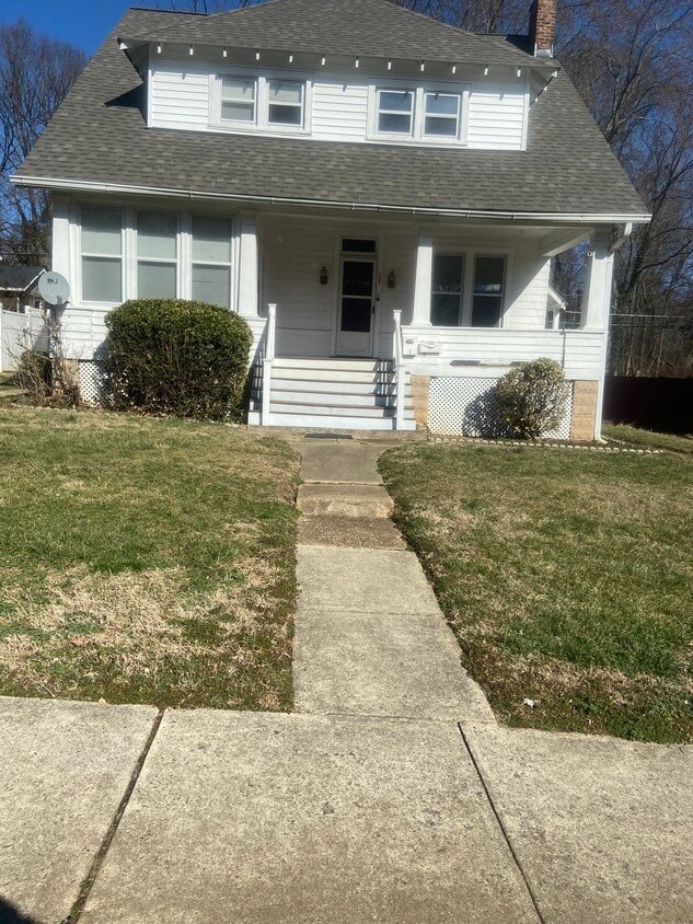
About This Property
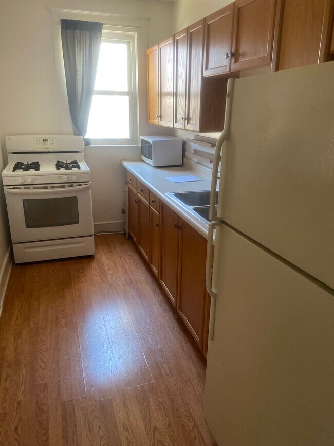
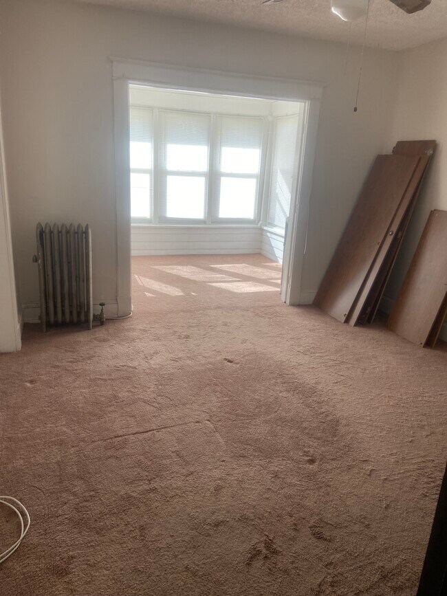
This home is divided into 2 apartments- first floor and- 2nd floor. This is the entire 1st floor. Apartment is on a residential street and quite quiet. Apartment is bright with many windows. The apartment also comes with a very large, covered front porch facing the street. There is off street parking behind the apartment.
237 Mallow Hill Rd is an apartment community located in Baltimore City County and the 21229 ZIP Code.
Apartment Features
- Smoke Free
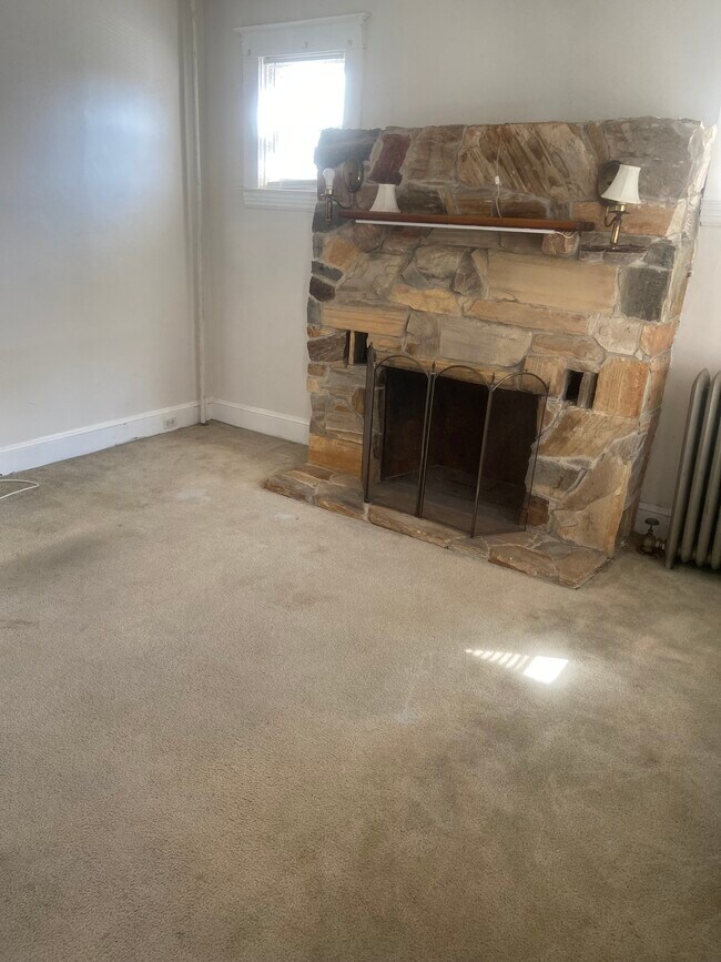
- Fireplace
- Laundry Facilities
- Porch
237 Mallow Hill Rd,
Baltimore,
MD
21229
In 1899, Baltimore was connected to Ellicott City by trolley. An undeveloped area about halfway between these two cities developed, and by 1913, Westgate was beginning to take shape. As a result, most of the homes in Westgate were built in the early 1900s. These homes tend to be bungalows, Cape Cods, and Tudor-style. Westgate begins along the Baltimore National Pike and extends south to Frederic Avenue, roughly three miles north of the University of Maryland-Baltimore County. Described as family-friendly and close-knit, Westgate is a terrific option for your Baltimore apartment, especially if you'd like to be close to the city but in a quieter community. Westgate has easy access to mass transit, with a MARC station leading to DC, roughly 38 miles southwest. Downtown Baltimore is about five miles east.
Several shops and restaurants are located just outside the neighborhood along Baltimore National Pike. The nearest grocery store, Giant Food, is on Edmonson Avenue.
Learn more about living in WestgateBelow are rent ranges for similar nearby apartments
Amenities
- Smoke Free
- Fireplace
- Laundry Facilities
- Porch
Expenses
Utilities Included
Gas, Water, Sewer
Included
Education
| Colleges & Universities | Distance | ||
|---|---|---|---|
| Colleges & Universities | Distance | ||
| Drive: | 8 min | 3.3 mi | |
| Drive: | 10 min | 3.8 mi | |
| Drive: | 13 min | 4.9 mi | |
| Drive: | 13 min | 4.9 mi |
237 Mallow Hill Rd Unit 237 Mallow Hill Rd is within 10 minutes or 3.8 miles from UMBC. It is also near CCBC Cantonsville and Univ. of Maryland-Baltimore.
Transportation options available in Baltimore include Upton, located 5.5 miles from 237 Mallow Hill Rd Unit 237 Mallow Hill Rd. 237 Mallow Hill Rd Unit 237 Mallow Hill Rd is near Baltimore/Washington International Thurgood Marshall, located 9.3 miles or 17 minutes away, and Ronald Reagan Washington Ntl, located 42.0 miles or 63 minutes away.
| Transit / Subway | Distance | ||
|---|---|---|---|
| Transit / Subway | Distance | ||
| Drive: | 15 min | 5.5 mi | |
| Drive: | 15 min | 5.5 mi | |
|
|
Drive: | 15 min | 5.6 mi |
| Drive: | 16 min | 5.6 mi | |
|
|
Drive: | 15 min | 6.1 mi |
| Commuter Rail | Distance | ||
|---|---|---|---|
| Commuter Rail | Distance | ||
| Drive: | 11 min | 4.0 mi | |
| Drive: | 9 min | 4.5 mi | |
| Drive: | 9 min | 4.5 mi | |
| Drive: | 14 min | 5.3 mi | |
| Drive: | 12 min | 6.3 mi |
| Airports | Distance | ||
|---|---|---|---|
| Airports | Distance | ||
|
Baltimore/Washington International Thurgood Marshall
|
Drive: | 17 min | 9.3 mi |
|
Ronald Reagan Washington Ntl
|
Drive: | 63 min | 42.0 mi |
Walkability Near 237 Mallow Hill Rd Baltimore, MD 21229
Getting Around
 What do Walkability, Transit, Drivability, and Bikeability mean?
Walkability measures the walking distance to day-to-day needs.
Transit measures access to public transportation.
Drivability measures congestion, parking availability, and access to major roads.
Bikeability measures the suitability for cycling.
How It Works
What do Walkability, Transit, Drivability, and Bikeability mean?
Walkability measures the walking distance to day-to-day needs.
Transit measures access to public transportation.
Drivability measures congestion, parking availability, and access to major roads.
Bikeability measures the suitability for cycling.
How It Works
Moderately Walkable
Walkability
60
/ 100
Limited Public Transit
Transit
30
/ 100
Very Drivable
Drivability
80
/ 100
Fairly Bikeable
Bikeability
40
/ 100
Scores provided by
-
Soundscore™
-
/ 100
Traffic
-Airport
-Businesses
-Scores provided by
HowLoud What is a Sound Score Rating? A Sound Score Rating aggregates noise caused by vehicle traffic, airplane traffic and local sources. How It WorksTime and distance from 237 Mallow Hill Rd Unit 237 Mallow Hill Rd.
| Shopping Centers | Distance | ||
|---|---|---|---|
| Shopping Centers | Distance | ||
| Walk: | 11 min | 0.6 mi | |
| Walk: | 11 min | 0.6 mi | |
| Drive: | 4 min | 1.3 mi |
237 Mallow Hill Rd Unit 237 Mallow Hill Rd has 3 shopping centers within 1.3 miles, which is about a 4-minute drive. The miles and minutes will be for the farthest away property.
| Parks and Recreation | Distance | ||
|---|---|---|---|
| Parks and Recreation | Distance | ||
|
Gwynns Falls Trail
|
Drive: | 8 min | 2.4 mi |
|
Carrie Murray Nature Center
|
Drive: | 9 min | 3.2 mi |
|
Banneker Planetarium
|
Drive: | 8 min | 3.3 mi |
|
Gwynns Falls - Leakin Park
|
Drive: | 9 min | 3.3 mi |
|
Carroll Park
|
Drive: | 14 min | 7.0 mi |
237 Mallow Hill Rd Unit 237 Mallow Hill Rd has 5 parks within 7.0 miles, including Gwynns Falls Trail, Gwynns Falls - Leakin Park, and Carrie Murray Nature Center.
| Hospitals | Distance | ||
|---|---|---|---|
| Hospitals | Distance | ||
| Drive: | 4 min | 1.4 mi | |
| Drive: | 7 min | 2.7 mi | |
| Drive: | 8 min | 2.9 mi |
237 Mallow Hill Rd Unit 237 Mallow Hill Rd has 3 hospitals within 2.9 miles, the nearest is Spring Grove Hospital Center which is 1.4 miles away and a 4 minute drive.
| Military Bases | Distance | ||
|---|---|---|---|
| Military Bases | Distance | ||
| Drive: | 30 min | 17.2 mi |
237 Mallow Hill Rd Unit 237 Mallow Hill Rd is 17.2 miles and a 30 minute drive from Fort George Meade.
You May Also Like
-
The Glendale Residence
9971 Good Luck Rd
Lanham, MD 20706
$1,620 - $2,953
1-4 Br 20.8 mi
-
Harborside Village Apartments
610 Towne Center Dr
Joppa, MD 21085
$1,535 - $2,095 Total Monthly Price
1-2 Br 12 Month Lease 21.0 mi
-
Franklin Park At Greenbelt Station
6220 Springhill Dr
Greenbelt, MD 20770
$1,357 - $2,649
1-3 Br 21.7 mi
Similar Rentals Nearby
-
-
1 / 25
 1 Bed$2,125+2 Beds$2,900+3 Beds$3,895+Total Monthly PriceTotal Monthly Price NewPrices include base rent and required monthly fees of $100. Variable costs based on usage may apply.Base Rent:1 Bed$2,025+2 Beds$2,800+3 Beds$3,795+2 Months Free
Pets Allowed Fitness Center Pool Dishwasher In Unit Washer & Dryer
-
-
-
-
-
-
-
-


What Are Walk Score®, Transit Score®, and Bike Score® Ratings?
Walk Score® measures the walkability of any address. Transit Score® measures access to public transit. Bike Score® measures the bikeability of any address.
What is a Sound Score Rating?
A Sound Score Rating aggregates noise caused by vehicle traffic, airplane traffic and local sources.
237 Mallow Hill Rd
Baltimore, MD 21229