

$4,200
/ Month
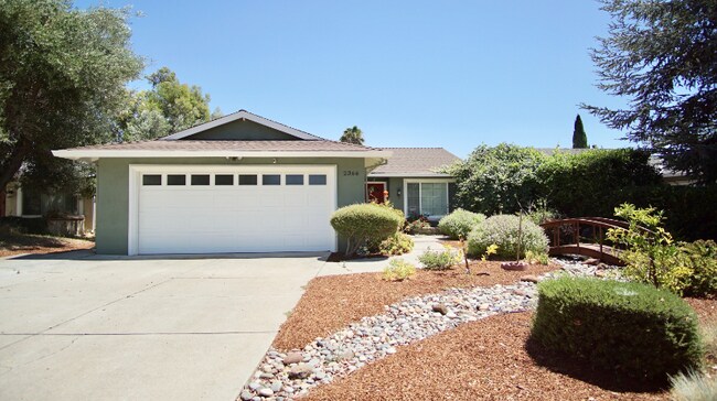
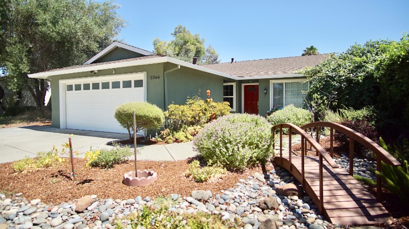
2366 Ohara Ct
San Jose, CA 95133
2 Weeks Ago
|
Edit
Favorites
2366 Ohara Ct

Favorites
Check Back Soon for Upcoming Availability
| Beds | Baths | Average SF |
|---|---|---|
| 4 Bedrooms 4 Bedrooms 4 Br | 2 Baths 2 Baths 2 Ba | 1,392 SF |
Fees and Policies
The fees listed below are community-provided and may exclude utilities or add-ons. All payments are made directly to the property and are non-refundable unless otherwise specified.
- Dogs Allowed
-
Fees not specified
-
Weight limit--
-
Pet Limit--
- Parking
-
Garage--
Details
Utilities Included
-
Trash Removal
-
Sewer
About This Property
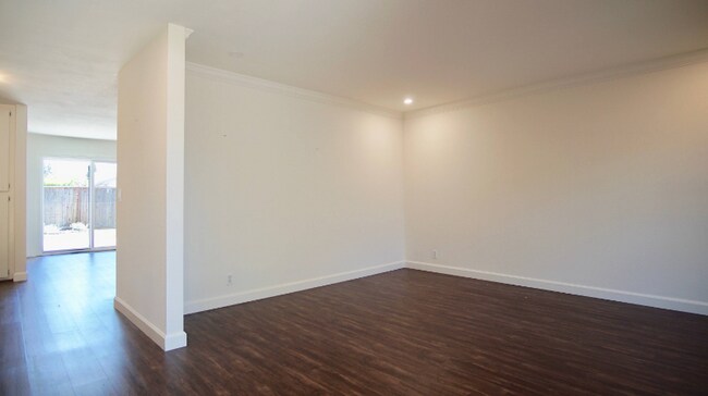
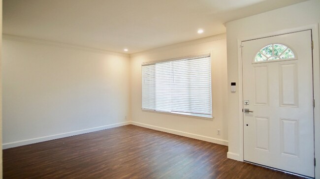
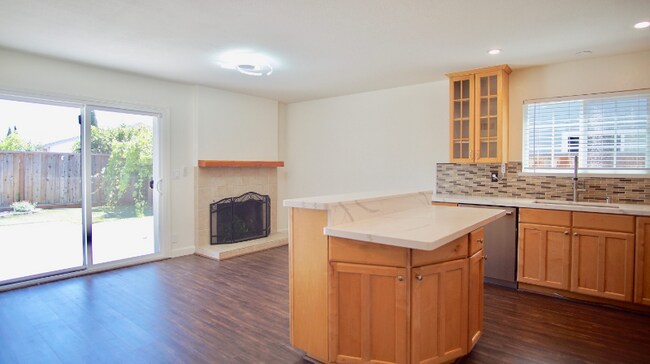
Property Id: 1532271 Beautiful 4 bedroom 2 bathroom home with peacefully curated front yard with a dry creek bed; upgraded Thermador appliances situated at the base of the San Jose hills. Enjoy the convenience of a 2 car garage with an in-unit Washer and dryer. Central AC and heating. Solar panels (paid off) to help reduce PGE cost! Conveniently located near restaurants, shopping, schools, and public transportation. The new BART station is 2 miles away. The light rail is within a mile. Easy access to the 680 and 101. Observe nature, hike and bike at Alum Rock Park, which is within 3 miles. Enjoy Overfelt Gardens and see the Chinese Cultural Garden and Penitencia Creek Park. Visit Commodore Park where there is a community garden, playground, fitness stations and a large grass play area. It is also a short distance to the public library! Contact us to schedule a showing, Landlord pays for garbage and sewer included, monthly landscape maintenance. Tenant responsible for water, PGE, and all other utilities.
2366 Ohara Ct is a house located in Santa Clara County and the 95133 ZIP Code. This area is served by the Berryessa Union Elementary School District attendance zone.
House Features
Washer/Dryer
Dishwasher
Hardwood Floors
Microwave
- Washer/Dryer
- Cable Ready
- Dishwasher
- Disposal
- Microwave
- Oven
- Refrigerator
- Freezer
- Hardwood Floors
- Fenced Lot
- Lawn
2366 Ohara Ct,
San Jose,
CA
95133
San Jose is the largest city in the San Francisco Bay Area and the beating heart of Silicon Valley, where major tech companies including Adobe, Cisco, and PayPal have long called home. Spanning 182 square miles at the southern end of the bay, it carries real weight as both an economic engine and a cultural center, anchored further by San Jose State University, whose downtown campus shapes much of the city's creative and intellectual energy. Founded in 1777 as California's first city, San Jose balances deep historical roots with an unmistakably forward-facing identity.
Neighborhoods here vary considerably in character. Willow Glen draws renters with tree-lined streets and a walkable village atmosphere along Lincoln Avenue, while the SoFA District and downtown offer a denser, arts-forward setting near SAP Center and The Tech Interactive. Almaden Valley sits closer to open hillside terrain, and Japantown preserves a distinct historic identity just north of downtown.
Learn more about living in San Jose
Amenities
- Washer/Dryer
- Cable Ready
- Dishwasher
- Disposal
- Microwave
- Oven
- Refrigerator
- Freezer
- Hardwood Floors
- Fenced Lot
- Lawn
Expenses
Utilities Included
Trash Removal, Sewer
Included
Education
| Colleges & Universities | Distance | ||
|---|---|---|---|
| Colleges & Universities | Distance | ||
| Drive: | 9 min | 4.2 mi | |
| Drive: | 13 min | 6.9 mi | |
| Drive: | 13 min | 7.3 mi | |
| Drive: | 13 min | 8.6 mi |
2366 Ohara Ct is within 9 minutes or 4.2 miles from San Jose State University. It is also near Santa Clara University and Palmer College of Chiropractic West Campus.
Schools


Public Elementary School
Grades K-5
362 Students
Nearby
Public Elementary School
Grades K-5
274 Students
Attendance Zone
Public Middle School
Grades 6-8
591 Students
Attendance Zone
Public High School
Grades 9-12
2,289 Students
Attendance Zone
Private Elementary & Middle School
Grades PK-8
Nearby
Private Elementary, Middle & High School
Grades K-12
11 Students
Nearby
Private Elementary School
Grades K-5
168 Students
Nearby
School data provided by
 The GreatSchools Rating helps parents compare schools within a state based on a variety of school quality indicators and provides a helpful picture of how effectively each school serves all of its students. Ratings are on a scale of 1 (below average) to 10 (above average) and can include test scores, college readiness, academic progress, advanced courses, equity, discipline and attendance data. We also advise parents to visit schools, consider other information on school performance and programs, and consider family needs as part of the school selection process.
View GreatSchools Rating Methodology
Data provided by GreatSchools.org © 2026. All rights reserved.
View GreatSchools Rating Methodology
Data provided by GreatSchools.org © 2026. All rights reserved.
Transportation options available in San Jose include Penitencia Creek Station, located 0.8 mile from 2366 Ohara Ct. 2366 Ohara Ct is near Norman Y Mineta San Jose International, located 6.2 miles or 12 minutes away, and Metro Oakland International, located 35.1 miles or 46 minutes away.
| Transit / Subway | Distance | ||
|---|---|---|---|
| Transit / Subway | Distance | ||
| Walk: | 16 min | 0.8 mi | |
| Drive: | 2 min | 1.3 mi | |
| Drive: | 2 min | 1.4 mi | |
|
|
Drive: | 5 min | 1.9 mi |
| Drive: | 4 min | 2.3 mi |
| Commuter Rail | Distance | ||
|---|---|---|---|
| Commuter Rail | Distance | ||
| Drive: | 9 min | 4.1 mi | |
| Drive: | 12 min | 6.8 mi | |
| Drive: | 11 min | 7.1 mi | |
| Drive: | 11 min | 7.1 mi | |
| Drive: | 11 min | 7.2 mi |
| Airports | Distance | ||
|---|---|---|---|
| Airports | Distance | ||
|
Norman Y Mineta San Jose International
|
Drive: | 12 min | 6.2 mi |
|
Metro Oakland International
|
Drive: | 46 min | 35.1 mi |
Walkability Near 2366 Ohara Ct San Jose, CA 95133
Getting Around
 What do Walkability, Transit, Drivability, and Bikeability mean?
Walkability measures the walking distance to day-to-day needs.
Transit measures access to public transportation.
Drivability measures congestion, parking availability, and access to major roads.
Bikeability measures the suitability for cycling.
How It Works
What do Walkability, Transit, Drivability, and Bikeability mean?
Walkability measures the walking distance to day-to-day needs.
Transit measures access to public transportation.
Drivability measures congestion, parking availability, and access to major roads.
Bikeability measures the suitability for cycling.
How It Works
Fairly Walkable
Walkability
50
/ 100
Some Public Transit
Transit
40
/ 100
Exceptionally Drivable
Drivability
90
/ 100
Moderately Bikeable
Bikeability
60
/ 100
Scores provided by
-
Soundscore™
-
/ 100
Traffic
-Airport
-Businesses
-Scores provided by
HowLoud What is a Sound Score Rating? A Sound Score Rating aggregates noise caused by vehicle traffic, airplane traffic and local sources. How It WorksTime and distance from 2366 Ohara Ct.
| Shopping Centers | Distance | ||
|---|---|---|---|
| Shopping Centers | Distance | ||
| Walk: | 17 min | 0.9 mi | |
| Walk: | 18 min | 0.9 mi | |
| Walk: | 20 min | 1.1 mi |
2366 Ohara Ct has 3 shopping centers within 1.1 miles, which is about a 20-minute walk. The miles and minutes will be for the farthest away property.
| Parks and Recreation | Distance | ||
|---|---|---|---|
| Parks and Recreation | Distance | ||
|
Penitencia Creek County Park
|
Drive: | 4 min | 1.9 mi |
|
Emma Prusch Farm Park
|
Drive: | 7 min | 3.9 mi |
|
Japanese Friendship Garden Regional Park
|
Drive: | 8 min | 4.0 mi |
|
The Tech Museum of Innovation
|
Drive: | 9 min | 4.6 mi |
|
Happy Hollow Park & Zoo
|
Drive: | 10 min | 5.7 mi |
2366 Ohara Ct has 5 parks within 5.7 miles, including Penitencia Creek County Park, Emma Prusch Farm Park, and Japanese Friendship Garden Regional Park.
| Hospitals | Distance | ||
|---|---|---|---|
| Hospitals | Distance | ||
| Walk: | 20 min | 1.0 mi | |
| Drive: | 12 min | 8.8 mi | |
| Drive: | 18 min | 13.4 mi |
2366 Ohara Ct has 3 hospitals within 13.4 miles, the nearest is Regional Medical Center of San Jose which is 1.0 miles away and a 20 minute walk.
| Military Bases | Distance | ||
|---|---|---|---|
| Military Bases | Distance | ||
| Drive: | 22 min | 14.1 mi |
2366 Ohara Ct is 14.1 miles and a 22 minute drive from Ames Research Center.
You May Also Like
Similar Rentals Nearby


What Are Walk Score®, Transit Score®, and Bike Score® Ratings?
Walk Score® measures the walkability of any address. Transit Score® measures access to public transit. Bike Score® measures the bikeability of any address.
What is a Sound Score Rating?
A Sound Score Rating aggregates noise caused by vehicle traffic, airplane traffic and local sources.
2366 Ohara Ct
San Jose, CA 95133