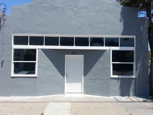

229 W Macdonald Ave
Richmond, CA 94801
|
Edit
Favorites
229 W Macdonald Ave

Favorites
Check Back Soon for Upcoming Availability
About This Property
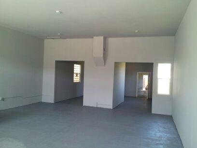
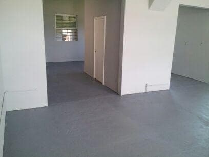
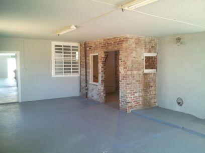
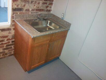
This newly remodeled Building is FOR SALE! $235,000.00 Great for a new or existing business looking to relocate and reduce their monthly rent expenses. 2001 sft. Open office space, restroom w/shower and kitchen area with granite counter tops. Lease 2 rooms (1,000 sft each). Business/Retail/Commercial/ Warehousing etc. Don’t miss out on this affordable rent on office space. Call Brenda Brown for showing and more details.. http://www.loopnet.com/lid/18279747
229 W Macdonald Ave is a house located in Contra Costa County and the 94801 ZIP Code.
Location
Get Directions
The Iron Triangle neighborhood sits in the heart of Central Richmond, California. With the area being largely residential, most rentals reside in the upper part of the triangle and an easy three-mile commute north to Point Richmond, a major shipping and industrial area. To the south, Berkeley and Oakland lie roughly 10 miles away via Interstate 580.
Locals often head for the Miller/Knox Regional Shoreline for a bit of jogging or cycling, or to cast a line off the fishing pier. Wade into the waters of San Francisco Bay at Keller Beach on the northern end of the park, or enjoy a show at the Masquers Playhouse, also just outside the Iron Triangle's southern border. Most eateries sit along Interstate 580, including several fast food chains. The MacDonald 80 Shopping Center lies roughly three miles east of the neighborhood. Drive another three miles and find Wildcat Canyon Regional Park and the Tilden Nature Area.
Learn more about living in Iron TriangleBelow are rent ranges for similar nearby apartments
Education
| Colleges & Universities | Distance | ||
|---|---|---|---|
| Colleges & Universities | Distance | ||
| Drive: | 8 min | 3.6 mi | |
| Drive: | 16 min | 9.3 mi | |
| Drive: | 20 min | 10.3 mi | |
| Drive: | 18 min | 10.8 mi |
229 W Macdonald Ave is within 8 minutes or 3.6 miles from Contra Costa College. It is also near Berkeley City College and UC Berkeley.
Transportation options available in Richmond include Richmond Station, located 1.2 miles from 229 W Macdonald Ave. 229 W Macdonald Ave is near Metro Oakland International, located 22.3 miles or 31 minutes away, and San Francisco International, located 29.9 miles or 43 minutes away.
| Transit / Subway | Distance | ||
|---|---|---|---|
| Transit / Subway | Distance | ||
|
|
Drive: | 3 min | 1.2 mi |
|
|
Drive: | 7 min | 3.4 mi |
|
|
Drive: | 7 min | 3.4 mi |
|
|
Drive: | 10 min | 5.5 mi |
|
|
Drive: | 14 min | 8.7 mi |
| Commuter Rail | Distance | ||
|---|---|---|---|
| Commuter Rail | Distance | ||
| Walk: | 14 min | 0.8 mi | |
|
|
Drive: | 12 min | 7.9 mi |
| Drive: | 16 min | 9.1 mi | |
|
|
Drive: | 14 min | 9.7 mi |
| Drive: | 16 min | 10.0 mi |
| Airports | Distance | ||
|---|---|---|---|
| Airports | Distance | ||
|
Metro Oakland International
|
Drive: | 31 min | 22.3 mi |
|
San Francisco International
|
Drive: | 43 min | 29.9 mi |
Time and distance from 229 W Macdonald Ave.
| Shopping Centers | Distance | ||
|---|---|---|---|
| Shopping Centers | Distance | ||
| Walk: | 11 min | 0.6 mi | |
| Drive: | 4 min | 2.1 mi | |
| Drive: | 5 min | 2.2 mi |
229 W Macdonald Ave has 3 shopping centers within 2.2 miles, which is about a 5-minute drive. The miles and minutes will be for the farthest away property.
| Parks and Recreation | Distance | ||
|---|---|---|---|
| Parks and Recreation | Distance | ||
|
Miller/Knox Regional Shoreline
|
Drive: | 5 min | 2.2 mi |
|
Rosie the Riveter WWII Home Front National Historical Park
|
Drive: | 5 min | 2.3 mi |
|
Marina Park & Green
|
Drive: | 6 min | 2.5 mi |
|
Shimada Friendship Park
|
Drive: | 7 min | 3.2 mi |
|
Brooks Island Regional Preserve
|
Drive: | 9 min | 3.8 mi |
229 W Macdonald Ave has 5 parks within 3.8 miles, including Rosie the Riveter WWII Home Front National Historical Park, Miller/Knox Regional Shoreline, and Marina Park & Green.
| Hospitals | Distance | ||
|---|---|---|---|
| Hospitals | Distance | ||
| Drive: | 19 min | 10.9 mi | |
| Drive: | 16 min | 11.8 mi | |
| Drive: | 17 min | 11.9 mi |
229 W Macdonald Ave has 3 hospitals within 11.9 miles, the nearest is Alta Bates Summit Medical Center - Alta Bates Campus which is 10.9 miles away and a 19 minute drive.
| Military Bases | Distance | ||
|---|---|---|---|
| Military Bases | Distance | ||
| Drive: | 8 min | 3.6 mi | |
| Drive: | 13 min | 6.1 mi | |
| Drive: | 25 min | 16.0 mi |
229 W Macdonald Ave has 3 military bases within 16.0 miles, the nearest is Armory West Contra Costa which is 3.6 miles away and a 8 minute drive.
You May Also Like
Similar Rentals Nearby


What Are Walk Score®, Transit Score®, and Bike Score® Ratings?
Walk Score® measures the walkability of any address. Transit Score® measures access to public transit. Bike Score® measures the bikeability of any address.
What is a Sound Score Rating?
A Sound Score Rating aggregates noise caused by vehicle traffic, airplane traffic and local sources