

$3,395
/ Month
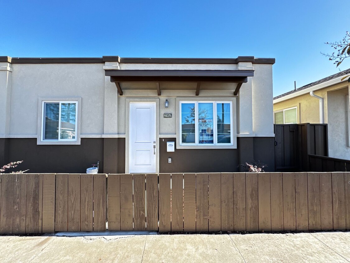
22852 Nevada Rd Unit 22852
Hayward, CA 94541
2 Weeks Ago
|
Edit
Favorites
-
Bedrooms
2
-
Bathrooms
2
-
Square Feet
747 sq ft
22852 Nevada Rd Unit 22852

Favorites
About This Home
$3,295 deposit
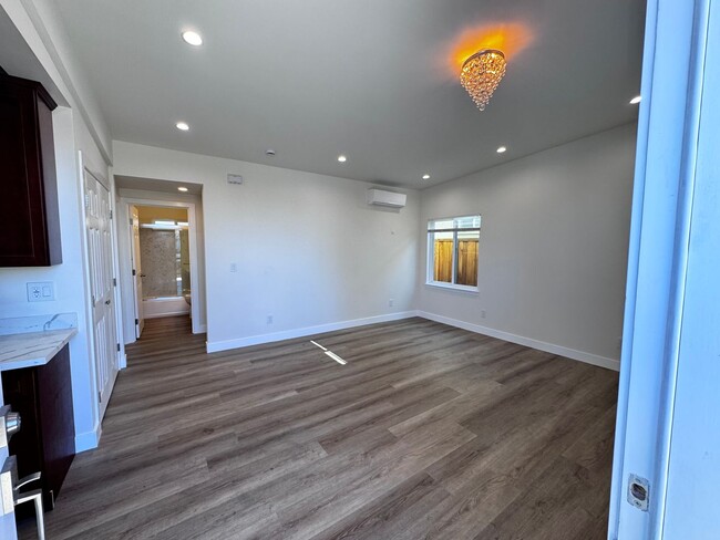
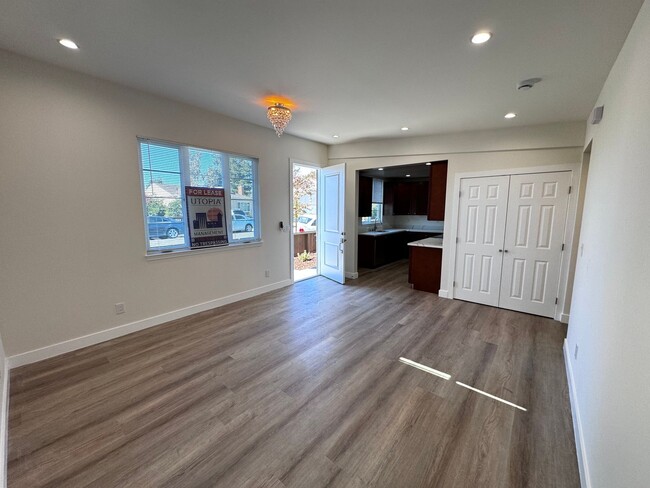
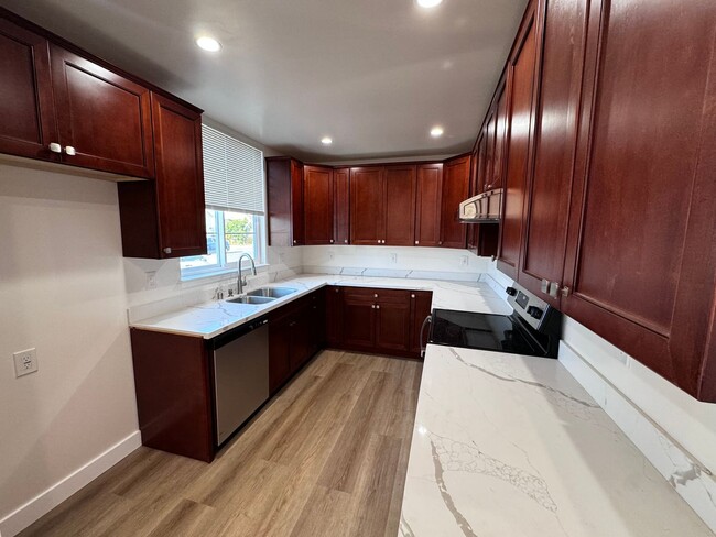
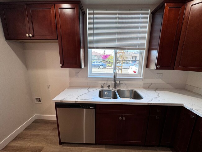
$500 MOVE IN SPECIAL!! 2 Bedroom/ 2 Bathroom SFH in Hayward- Quick freeway access and near shopping centers!! Features: -Newly Remodeled unit -Back Patio -Marble countertops -Garbage disposal -Electrical stove -Stainless steel dishwasher and sink -Laminated wood flooring -AC/Heating unit -Washer/Dryer hookups -Lots of cabinet space Contact us NOW! DRE 01197438 Utopia East Bay Branch
22852 Nevada Rd is a condo located in Alameda County and the 94541 ZIP Code.
* Price shown is base rent. Excludes user-selected optional fees and variable or usage-based fees and required charges due at or prior to move-in or at move-out. Price, availability, fees, and any applicable rent special are subject to change without notice.
* Square footage definitions vary. Displayed square footage is approximate.
Contact
- Listed by Utopia Management Inc. | Utopia Management Inc.
Location
Get Directions
Located in the East Bay, Hayward combines city living with natural surroundings. The rental market remains steady, with one-bedroom apartments averaging $2,102 and showing a 2% annual increase. Housing choices include downtown apartments and residential areas near California State University, East Bay. With two BART stations and easy freeway access, Hayward provides convenient transportation for Bay Area commuters. Outdoor spaces include the Hayward Regional Shoreline and Japanese Gardens, which features traditional design elements dating back generations.
Downtown Hayward showcases public art through its mural program, adding character to the streetscape. The California State University, East Bay campus sits atop the hills, while Chabot College adds to the educational landscape. Historic architecture dots the city, including the distinctive City Hall and the Green Shutter Hotel, a National Register of Historic Places landmark.
Learn more about living in Hayward
Education
| Colleges & Universities | Distance | ||
|---|---|---|---|
| Colleges & Universities | Distance | ||
| Drive: | 6 min | 2.5 mi | |
| Drive: | 10 min | 3.9 mi | |
| Drive: | 21 min | 11.9 mi | |
| Drive: | 18 min | 12.4 mi |
22852 Nevada Rd Unit 22852 is within 6 minutes or 2.5 miles from Chabot College. It is also near Cal State East Bay and Mills College.
Transportation options available in Hayward include Hayward Station, located 1.9 miles from 22852 Nevada Rd Unit 22852. 22852 Nevada Rd Unit 22852 is near Metro Oakland International, located 9.5 miles or 15 minutes away, and San Francisco International, located 22.4 miles or 30 minutes away.
| Transit / Subway | Distance | ||
|---|---|---|---|
| Transit / Subway | Distance | ||
|
|
Drive: | 5 min | 1.9 mi |
|
|
Drive: | 8 min | 3.6 mi |
|
|
Drive: | 10 min | 4.8 mi |
|
|
Drive: | 9 min | 6.0 mi |
|
|
Drive: | 11 min | 6.8 mi |
| Commuter Rail | Distance | ||
|---|---|---|---|
| Commuter Rail | Distance | ||
| Drive: | 4 min | 1.4 mi | |
|
|
Drive: | 4 min | 1.4 mi |
| Drive: | 16 min | 9.7 mi | |
| Drive: | 17 min | 9.8 mi | |
| Drive: | 27 min | 19.3 mi |
| Airports | Distance | ||
|---|---|---|---|
| Airports | Distance | ||
|
Metro Oakland International
|
Drive: | 15 min | 9.5 mi |
|
San Francisco International
|
Drive: | 30 min | 22.4 mi |
Time and distance from 22852 Nevada Rd Unit 22852.
| Shopping Centers | Distance | ||
|---|---|---|---|
| Shopping Centers | Distance | ||
| Walk: | 14 min | 0.7 mi | |
| Walk: | 14 min | 0.8 mi | |
| Drive: | 3 min | 1.2 mi |
22852 Nevada Rd Unit 22852 has 3 shopping centers within 1.2 miles, which is about a 3-minute drive. The miles and minutes will be for the farthest away property.
| Parks and Recreation | Distance | ||
|---|---|---|---|
| Parks and Recreation | Distance | ||
|
Sulphur Creek Nature Center
|
Drive: | 10 min | 3.7 mi |
|
Hayward Shoreline Interpretive Center
|
Drive: | 10 min | 4.5 mi |
|
Don Castro Regional Recreation Area
|
Drive: | 10 min | 4.7 mi |
|
Hayward Regional Shoreline
|
Drive: | 13 min | 4.9 mi |
|
Lake Chabot Regional Park
|
Drive: | 12 min | 6.3 mi |
22852 Nevada Rd Unit 22852 has 5 parks within 6.3 miles, including Sulphur Creek Nature Center, Hayward Shoreline Interpretive Center, and Don Castro Regional Recreation Area.
| Hospitals | Distance | ||
|---|---|---|---|
| Hospitals | Distance | ||
| Drive: | 7 min | 3.1 mi | |
| Drive: | 8 min | 4.5 mi | |
| Drive: | 10 min | 5.9 mi |
22852 Nevada Rd Unit 22852 has 3 hospitals within 5.9 miles, the nearest is St. Rose Hospital which is 3.1 miles away and a 7 minute drive.
| Military Bases | Distance | ||
|---|---|---|---|
| Military Bases | Distance | ||
| Drive: | 27 min | 17.0 mi | |
| Drive: | 27 min | 17.2 mi |
22852 Nevada Rd Unit 22852 is 17.0 miles from Alameda/US Naval Air Station Alameda, and is convenient to other military bases, including Alameda/US Naval Air Station San Francisco.
You May Also Like
Similar Rentals Nearby
-
-

-

-

-

-
1 / 34

-
-
-
-


What Are Walk Score®, Transit Score®, and Bike Score® Ratings?
Walk Score® measures the walkability of any address. Transit Score® measures access to public transit. Bike Score® measures the bikeability of any address.
What is a Sound Score Rating?
A Sound Score Rating aggregates noise caused by vehicle traffic, airplane traffic and local sources
22852 Nevada Rd
Hayward, CA 94541