

$3,195
/ Month
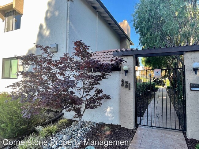
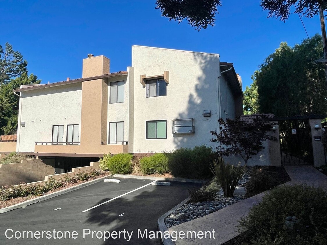
221 Easy St
Mountain View, CA 94043
2 Weeks Ago
Favorites
-
Bedrooms
2
-
Bathrooms
1.5
-
Square Feet
1,040 sq ft
221 Easy St

Favorites
About This Home
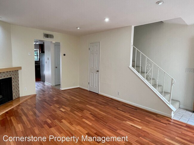
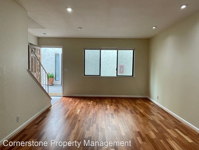
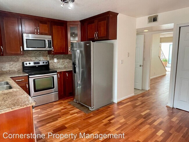
- Spacious and Updated 2 Bedroom, 1.5 Bathroom Condo in Mountain View - Come see this spacious and updated 2 bedroom, 1.5 bathroom, two-story condo in Mountain View located in close proximity to Castro St, downtown Farmer's Market and Caltrain Station! Kitchen features updated cabinets, quartz countertops, sit-in dining area, and all stainless steel appliances including side-by-side refrigerator, electric range w/ single oven, dishwasher, & microwave. Other features include hardwood flooring on first floor and carpet throughout upstairs, recessed lighting and spotlight fixtures, central heating, private balcony off upstairs bedroom, fenced back patio, *full size washer & dryer in unit* and 2 assigned parking spaces. Conveniently located near Steven's Creek Trail, and Tech companies. Easy access to Hwys 101, 237, and 85! -Garbage utility included in rent -Sorry no pets are being accepted. -Renter's Insurance will be required. (RLNE7521438) Appliances: Refrigerator, Washer & Dryer. Utilities: Trash Pick-up Included.
221 Easy St is a house located in Santa Clara County and the 94043 ZIP Code. This area is served by the Mountain View Whisman attendance zone.
* Price shown is base rent. Excludes user-selected optional fees and variable or usage-based fees and required charges due at or prior to move-in or at move-out. Price, availability, fees, and any applicable rent special are subject to change without notice.
* Square footage definitions vary. Displayed square footage is approximate.
House Features
- Washer/Dryer
Fees and Policies
The fees below are based on community-supplied data and may exclude additional fees and utilities.
Contact
- Listed by Cornerstone Property Management
Location
Get Directions
Amenities
- Washer/Dryer
Known for its fantastic views of the Santa Cruz Mountains, the Wagon Wheel neighborhood of Mountain View, California lies 12 miles southeast of Palo Alto via US-101S. Residents of Wagon Wheel's apartments and home rentals enjoy convenient transportation via light rail, bus, and private shuttle. Featuring an online chat group, this community values resident participation in planning activities such as ice cream socials, community breakfasts, and pumpkin festivals at the local park.
Two parks serve this neighborhood where residents can picnic, relax in an arbor, or join a pick-up baseball game. Whisman Park provides access to the Stevens Creek Trail, with its paved paths for walking, biking, or jogging through scenic natural areas.
Learn more about living in Wagon Wheel
Education
| Colleges & Universities | Distance | ||
|---|---|---|---|
| Colleges & Universities | Distance | ||
| Drive: | 8 min | 3.6 mi | |
| Drive: | 14 min | 5.6 mi | |
| Drive: | 12 min | 6.7 mi | |
| Drive: | 17 min | 7.2 mi |
221 Easy St is within 8 minutes or 3.6 miles from Foothill College, Middlefield. It is also near Foothill Coll., Los Altos and De Anza College.
Schools


Public Elementary School
Grades K-5
367 Students
Nearby
Public Elementary School
Grades K-5
374 Students
Attendance Zone
Public Middle School
Grades 6-8
537 Students
Attendance Zone
Public High School
Grades 9-12
2,220 Students
Attendance Zone
Private Elementary School
Grades PK-6
Nearby
Private Elementary, Middle & High School
Grades K-12
597 Students
Nearby
School data provided by
 The GreatSchools Rating helps parents compare schools within a state based on a variety of school quality indicators and provides a helpful picture of how effectively each school serves all of its students. Ratings are on a scale of 1 (below average) to 10 (above average) and can include test scores, college readiness, academic progress, advanced courses, equity, discipline and attendance data. We also advise parents to visit schools, consider other information on school performance and programs, and consider family needs as part of the school selection process.
View GreatSchools Rating Methodology
Data provided by GreatSchools.org © 2025. All rights reserved.
View GreatSchools Rating Methodology
Data provided by GreatSchools.org © 2025. All rights reserved.
Transportation options available in Mountain View include Whisman Station, located 0.7 mile from 221 Easy St. 221 Easy St is near Norman Y Mineta San Jose International, located 9.1 miles or 14 minutes away, and San Francisco International, located 25.5 miles or 32 minutes away.
| Transit / Subway | Distance | ||
|---|---|---|---|
| Transit / Subway | Distance | ||
|
|
Walk: | 14 min | 0.7 mi |
|
|
Walk: | 18 min | 0.9 mi |
| Drive: | 3 min | 1.1 mi | |
|
|
Drive: | 3 min | 1.1 mi |
| Drive: | 3 min | 1.5 mi |
| Commuter Rail | Distance | ||
|---|---|---|---|
| Commuter Rail | Distance | ||
| Drive: | 6 min | 2.0 mi | |
| Drive: | 5 min | 2.0 mi | |
| Drive: | 7 min | 3.2 mi | |
| Drive: | 7 min | 3.7 mi | |
| Drive: | 10 min | 5.1 mi |
| Airports | Distance | ||
|---|---|---|---|
| Airports | Distance | ||
|
Norman Y Mineta San Jose International
|
Drive: | 14 min | 9.1 mi |
|
San Francisco International
|
Drive: | 32 min | 25.5 mi |
Time and distance from 221 Easy St.
| Shopping Centers | Distance | ||
|---|---|---|---|
| Shopping Centers | Distance | ||
| Walk: | 17 min | 0.9 mi | |
| Drive: | 4 min | 1.4 mi | |
| Drive: | 5 min | 2.2 mi |
221 Easy St has 3 shopping centers within 2.2 miles, which is about a 5-minute walk. The miles and minutes will be for the farthest away property.
| Parks and Recreation | Distance | ||
|---|---|---|---|
| Parks and Recreation | Distance | ||
|
Stevens Creek Shoreline Nature Study Area
|
Drive: | 8 min | 3.4 mi |
|
J. Pearce Mitchell Park
|
Drive: | 10 min | 4.4 mi |
|
Terman Park
|
Drive: | 11 min | 4.8 mi |
|
Redwood Grove
|
Drive: | 13 min | 5.0 mi |
|
Esther Clark Nature Preserve
|
Drive: | 14 min | 5.9 mi |
221 Easy St has 5 parks within 5.9 miles, including Stevens Creek Shoreline Nature Study Area, J. Pearce Mitchell Park, and Terman Park.
| Hospitals | Distance | ||
|---|---|---|---|
| Hospitals | Distance | ||
| Drive: | 6 min | 2.6 mi | |
| Drive: | 13 min | 7.6 mi | |
| Drive: | 14 min | 7.8 mi |
221 Easy St has 3 hospitals within 7.8 miles, the nearest is El Camino Hospital which is 2.6 miles away and a 6 minute drive.
| Military Bases | Distance | ||
|---|---|---|---|
| Military Bases | Distance | ||
| Drive: | 7 min | 2.5 mi |
221 Easy St is 2.5 miles and a 7 minute drive from Ames Research Center.
You May Also Like
Similar Rentals Nearby


What Are Walk Score®, Transit Score®, and Bike Score® Ratings?
Walk Score® measures the walkability of any address. Transit Score® measures access to public transit. Bike Score® measures the bikeability of any address.
What is a Sound Score Rating?
A Sound Score Rating aggregates noise caused by vehicle traffic, airplane traffic and local sources
221 Easy St
Mountain View, CA 94043