
1213 Walnut
1213 Walnut St,
Philadelphia, PA 19107
$2,350 - $5,739
Studio - 2 Beds

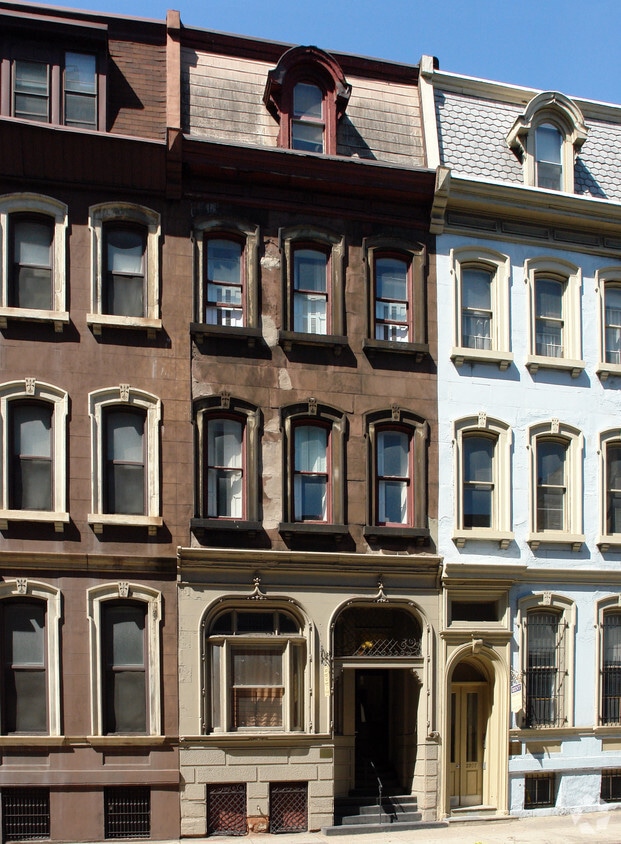
Find your new apartment at 2209 Walnut St in Philadelphia, PA. This community has a variety of amenities and features. Some of these include: washers and dryers, convenient on-site parking options, and hardwood floors. The professional leasing team is ready for your visit. Come see 2209 Walnut St today.
2209 Walnut St is an apartment community located in Philadelphia County and the 19103 ZIP Code. This area is served by the The School District of Philadelphia attendance zone.
Washer/Dryer
Dishwasher
High Speed Internet Access
Hardwood Floors
Center City West is a neighborhood within Center City, the downtown district of Philadelphia. This urban hub is one of Philadelphia's most desirable neighborhoods. The Center City West neighborhood encompasses some of the city's biggest attractions including the shopping, financial, and museum districts. It attracts its residents by not only hosting some of the city's leading institutions of art, science, and history, but also with its upscale restaurants and a booming nightlife. The options are endless: Laugh tears of joy at the Helium Comedy Club, have a shopping spree at the Shops at Liberty Place, or get a spectacular panoramic view 57 stories above the ground at the One Liberty Observation Deck. Nearby Rittenhouse Square is a popular spot for festivals and farmers markets while the Schuylkill Banks has excellent riverside running and biking trails with a view.
Learn more about living in Center City WestCompare neighborhood and city base rent averages by bedroom.
| Center City West | Philadelphia, PA | |
|---|---|---|
| Studio | $1,873 | $1,408 |
| 1 Bedroom | $2,552 | $1,765 |
| 2 Bedrooms | $3,869 | $2,205 |
| 3 Bedrooms | $4,689 | $2,932 |
| Colleges & Universities | Distance | ||
|---|---|---|---|
| Colleges & Universities | Distance | ||
| Walk: | 12 min | 0.6 mi | |
| Walk: | 13 min | 0.7 mi | |
| Walk: | 16 min | 0.9 mi | |
| Drive: | 4 min | 2.0 mi |


Transportation options available in Philadelphia include 22Nd Street, located 0.3 mile from 2209 Walnut St. 2209 Walnut St is near Philadelphia International, located 9.2 miles or 18 minutes away, and Trenton Mercer, located 35.0 miles or 51 minutes away.
| Transit / Subway | Distance | ||
|---|---|---|---|
| Transit / Subway | Distance | ||
|
|
Walk: | 5 min | 0.3 mi |
| Walk: | 10 min | 0.5 mi | |
|
|
Walk: | 10 min | 0.5 mi |
|
|
Walk: | 13 min | 0.7 mi |
| Walk: | 15 min | 0.8 mi |
| Commuter Rail | Distance | ||
|---|---|---|---|
| Commuter Rail | Distance | ||
|
|
Walk: | 9 min | 0.5 mi |
| Drive: | 3 min | 1.2 mi | |
|
|
Drive: | 5 min | 1.6 mi |
|
|
Drive: | 4 min | 1.8 mi |
|
|
Drive: | 6 min | 2.6 mi |
| Airports | Distance | ||
|---|---|---|---|
| Airports | Distance | ||
|
Philadelphia International
|
Drive: | 18 min | 9.2 mi |
|
Trenton Mercer
|
Drive: | 51 min | 35.0 mi |
Scores provided by
Traffic
-Airport
-Businesses
-Scores provided by
HowLoud What is a Sound Score Rating? A Sound Score Rating aggregates noise caused by vehicle traffic, airplane traffic and local sources. How It WorksTime and distance from 2209 Walnut St.
| Shopping Centers | Distance | ||
|---|---|---|---|
| Shopping Centers | Distance | ||
| Walk: | 14 min | 0.7 mi | |
| Walk: | 15 min | 0.8 mi | |
| Drive: | 4 min | 1.5 mi |
| Parks and Recreation | Distance | ||
|---|---|---|---|
| Parks and Recreation | Distance | ||
|
Schuylkill River Park
|
Walk: | 5 min | 0.3 mi |
|
Franklin Institute
|
Walk: | 14 min | 0.7 mi |
|
Fels Planetarium
|
Walk: | 14 min | 0.7 mi |
|
University of Pennsylvania Observatory
|
Drive: | 3 min | 1.1 mi |
|
The Academy of Natural Sciences
|
Drive: | 3 min | 1.4 mi |
| Hospitals | Distance | ||
|---|---|---|---|
| Hospitals | Distance | ||
| Drive: | 5 min | 1.4 mi | |
| Drive: | 3 min | 1.4 mi | |
| Drive: | 6 min | 1.7 mi |
| Military Bases | Distance | ||
|---|---|---|---|
| Military Bases | Distance | ||
| Drive: | 11 min | 5.9 mi |
What Are Walk Score®, Transit Score®, and Bike Score® Ratings?
Walk Score® measures the walkability of any address. Transit Score® measures access to public transit. Bike Score® measures the bikeability of any address.
What is a Sound Score Rating?
A Sound Score Rating aggregates noise caused by vehicle traffic, airplane traffic and local sources.

2209 Walnut St
Philadelphia, PA 19103


