

$5,500
/ Month
22087 San Fernando Ct
Cupertino, CA 95014
Favorites
22087 San Fernando Ct

Favorites
Check Back Soon for Upcoming Availability
| Beds | Baths | Average SF |
|---|---|---|
| 4 Bedrooms 4 Bedrooms 4 Br | 2 Baths 2 Baths 2 Ba | 2,749 SF |
About This Property
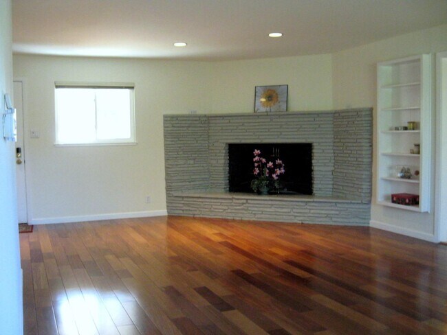
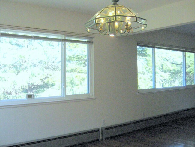
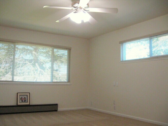
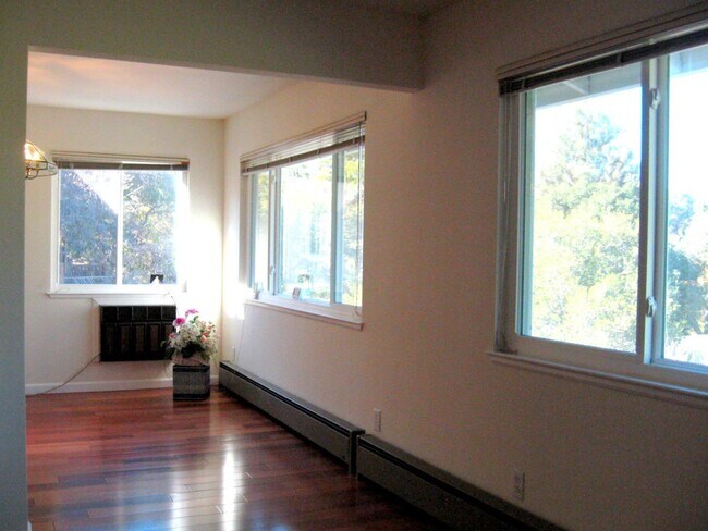
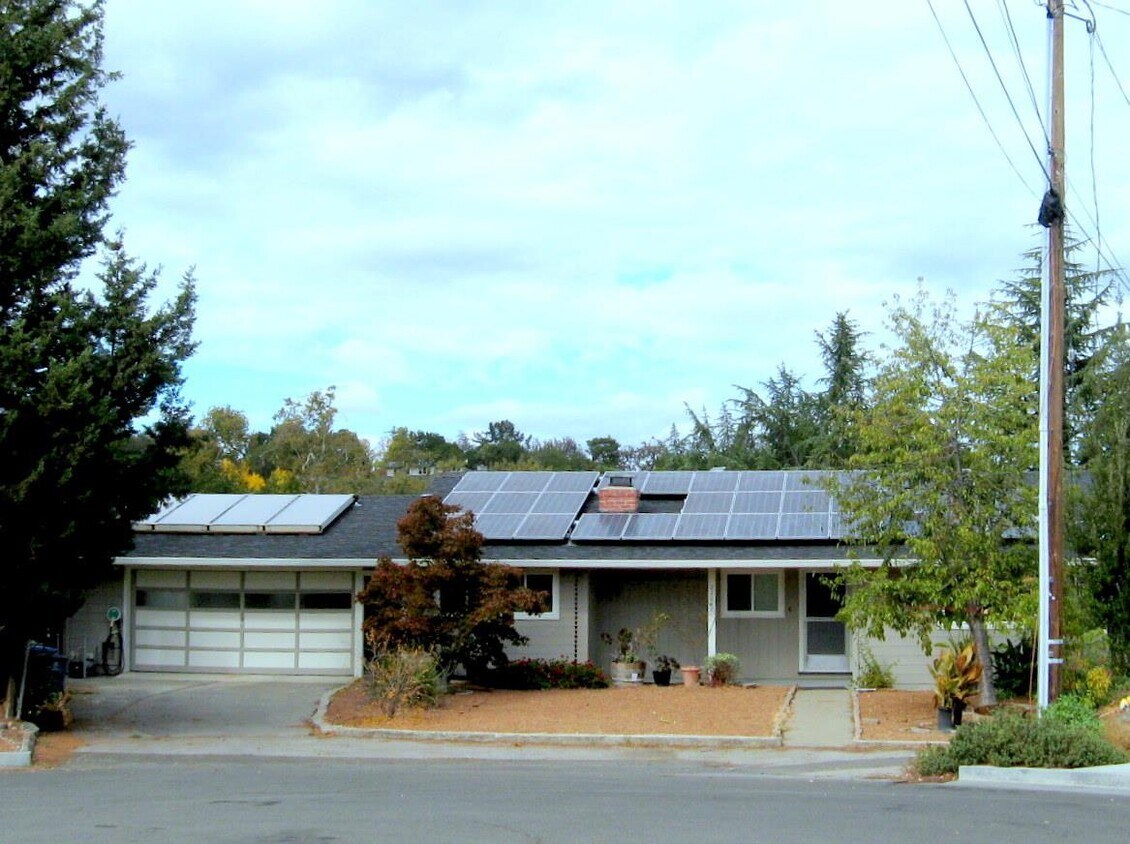
Sought after Cul-de-Sac location! Fantastic 4 bedroom 2 full baths home in Monta Vista neighborhood. Close to top schools - Monta Vista High, Kennedy Middle & Lincoln Elementary, DeAnza College, Blackberry Farm Park, Golf Courses. Easy commute to 85/280& Foothill Expressway. Spacious living and dining room overlooking tranquil park scenery. Separate family room with movie projector provisions. Beautiful hardwood floor. Large kitchen with modern appliances. Large laundry with washer & dryer, plenty storage cabinets. Double pane windows. Veranda downstairs good for relaxation & entertaining. Power by Mitsubishi solar panels providing energy savings. Mitsubishi Electric Mr. Slim mini-split A/C with heat pump heating & thermostat controls. Humidity sensing bathroom fan switch. 2-car attached garage Epoxy garage floor. EV Level 2 (240 V) charge station for EV. Security deposit $6,500. 12-18 month lease term. No Pets, No smoking.
22087 San Fernando Ct is a house located in Santa Clara County and the 95014 ZIP Code. This area is served by the Cupertino Union School District attendance zone.
22087 San Fernando Ct,
Cupertino,
CA
95014
Located in the heart of Silicon Valley, Cupertino combines suburban living with technological advancement. The city, home to Apple Inc.'s distinctive Apple Park headquarters, features tree-lined streets and rolling foothills. Housing includes apartments, townhouses, and single-family homes throughout various neighborhoods. Current rental data shows one-bedroom apartments averaging $3,138 per month, while three-bedroom units average $4,994.
The city features De Anza College, set on a 112-acre campus. Outdoor enthusiasts can explore the Stevens Creek Trail, which winds through McClellan Ranch Park and Blackberry Farm. Memorial Park hosts community events and concerts throughout the year. The Cupertino Library serves as a central resource for residents, ranking as Santa Clara County's most active branch. The area's history dates back to Spanish exploration, when the region was named after Arroyo San José de Cupertino, a creek named in honor of Saint Joseph of Cupertino.
Learn more about living in CupertinoBelow are rent ranges for similar nearby apartments
Education
| Colleges & Universities | Distance | ||
|---|---|---|---|
| Colleges & Universities | Distance | ||
| Drive: | 5 min | 1.5 mi | |
| Drive: | 13 min | 6.6 mi | |
| Drive: | 13 min | 6.8 mi | |
| Drive: | 20 min | 10.2 mi |
22087 San Fernando Ct is within 5 minutes or 1.5 miles from De Anza College. It is also near West Valley College and Foothill Coll., Los Altos.
Schools


Public Elementary School
Grades K-5
407 Students
Nearby
Public Elementary School
Grades K-5
662 Students
Attendance Zone
Public Middle School
Grades 6-8
880 Students
Attendance Zone
Public High School
Grades 9-12
1,630 Students
Attendance Zone
Private Elementary & Middle School
Grades PK-8
186 Students
Nearby
Private Elementary, Middle & High School
Grades K-12
Nearby
Private Elementary School
Grades K-5
Nearby
Private Middle & High School
Grades 6-12
Nearby
School data provided by
 The GreatSchools Rating helps parents compare schools within a state based on a variety of school quality indicators and provides a helpful picture of how effectively each school serves all of its students. Ratings are on a scale of 1 (below average) to 10 (above average) and can include test scores, college readiness, academic progress, advanced courses, equity, discipline and attendance data. We also advise parents to visit schools, consider other information on school performance and programs, and consider family needs as part of the school selection process.
View GreatSchools Rating Methodology
Data provided by GreatSchools.org © 2026. All rights reserved.
View GreatSchools Rating Methodology
Data provided by GreatSchools.org © 2026. All rights reserved.
Transportation options available in Cupertino include Whisman Station, located 6.7 miles from 22087 San Fernando Ct. 22087 San Fernando Ct is near Norman Y Mineta San Jose International, located 12.6 miles or 21 minutes away, and San Francisco International, located 31.5 miles or 42 minutes away.
| Transit / Subway | Distance | ||
|---|---|---|---|
| Transit / Subway | Distance | ||
|
|
Drive: | 13 min | 6.7 mi |
| Drive: | 12 min | 6.7 mi | |
|
|
Drive: | 13 min | 7.0 mi |
| Drive: | 14 min | 8.2 mi | |
| Drive: | 15 min | 8.7 mi |
| Commuter Rail | Distance | ||
|---|---|---|---|
| Commuter Rail | Distance | ||
| Drive: | 14 min | 6.1 mi | |
| Drive: | 12 min | 6.5 mi | |
| Drive: | 17 min | 8.6 mi | |
| Drive: | 16 min | 8.9 mi | |
| Drive: | 19 min | 10.0 mi |
| Airports | Distance | ||
|---|---|---|---|
| Airports | Distance | ||
|
Norman Y Mineta San Jose International
|
Drive: | 21 min | 12.6 mi |
|
San Francisco International
|
Drive: | 42 min | 31.5 mi |
Walkability Near 22087 San Fernando Ct Cupertino, CA 95014
Getting Around
 What do Walkability, Transit, Drivability, and Bikeability mean?
Walkability measures the walking distance to day-to-day needs.
Transit measures access to public transportation.
Drivability measures congestion, parking availability, and access to major roads.
Bikeability measures the suitability for cycling.
How It Works
What do Walkability, Transit, Drivability, and Bikeability mean?
Walkability measures the walking distance to day-to-day needs.
Transit measures access to public transportation.
Drivability measures congestion, parking availability, and access to major roads.
Bikeability measures the suitability for cycling.
How It Works
Somewhat Walkable
Walkability
30
/ 100
Minimal Public Transit
Transit
10
/ 100
Exceptionally Drivable
Drivability
100
/ 100
Moderately Bikeable
Bikeability
60
/ 100
Scores provided by
-
Soundscore™
-
/ 100
Traffic
-Airport
-Businesses
-Scores provided by
HowLoud What is a Sound Score Rating? A Sound Score Rating aggregates noise caused by vehicle traffic, airplane traffic and local sources. How It WorksTime and distance from 22087 San Fernando Ct.
| Shopping Centers | Distance | ||
|---|---|---|---|
| Shopping Centers | Distance | ||
| Drive: | 5 min | 1.5 mi | |
| Drive: | 6 min | 1.8 mi | |
| Drive: | 5 min | 1.9 mi |
22087 San Fernando Ct has 3 shopping centers within 1.9 miles, which is about a 5-minute drive. The miles and minutes will be for the farthest away property.
| Parks and Recreation | Distance | ||
|---|---|---|---|
| Parks and Recreation | Distance | ||
|
McClellan Ranch Park
|
Walk: | 14 min | 0.8 mi |
|
Fujitsu Planetarium
|
Drive: | 5 min | 1.5 mi |
|
Fremont Older Open Space Preserve
|
Drive: | 9 min | 2.3 mi |
|
Deer Hollow Farm
|
Drive: | 10 min | 3.3 mi |
|
Rancho San Antonio County Park
|
Drive: | 10 min | 3.4 mi |
22087 San Fernando Ct has 5 parks within 3.4 miles, including McClellan Ranch Park, Fujitsu Planetarium, and Fremont Older Open Space Preserve.
| Hospitals | Distance | ||
|---|---|---|---|
| Hospitals | Distance | ||
| Drive: | 11 min | 5.3 mi | |
| Drive: | 12 min | 5.7 mi | |
| Drive: | 12 min | 6.5 mi |
22087 San Fernando Ct has 3 hospitals within 6.5 miles, the nearest is Kaiser Permanente Psychiatric Health Facility - Santa Clara which is 5.3 miles away and a 11 minute drive.
| Military Bases | Distance | ||
|---|---|---|---|
| Military Bases | Distance | ||
| Drive: | 17 min | 8.5 mi | |
| Drive: | 66 min | 47.7 mi | |
| Drive: | 67 min | 47.9 mi |
22087 San Fernando Ct has 3 military bases within 47.9 miles, the nearest is Ames Research Center which is 8.5 miles away and a 17 minute drive.
You May Also Like
Similar Rentals Nearby


What Are Walk Score®, Transit Score®, and Bike Score® Ratings?
Walk Score® measures the walkability of any address. Transit Score® measures access to public transit. Bike Score® measures the bikeability of any address.
What is a Sound Score Rating?
A Sound Score Rating aggregates noise caused by vehicle traffic, airplane traffic and local sources.
22087 San Fernando Ct
Cupertino, CA 95014