
Presidential Towers
555 W Madison St,
Chicago, IL 60661
$1,696 - $6,620
Studio - 2 Beds

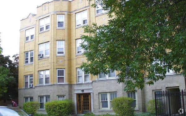
Trendy Logan Square is a hotspot for culture lovers from all walks of life. The Beaux-Arts architectural design of this sunny yellow-brick building creates tons of curb appeal. This building is close to Metra Healey stop and CTA bus stops. s. Several grocery stores are within just a few blocks, while nearby Fullerton Avenues bustling businessesrestaurants, bakeries, cafes, antique stores, and moreare a five minutes walk away.
2200-04 N. Avers Ave. is an apartment community located in Cook County and the 60647 ZIP Code. This area is served by the Chicago Public Schools attendance zone.
Unique Features
Recycling
Gated
24 Hour Access
Public Transportation
Hardwood Floors
Microwave
Refrigerator
Ceiling Fans
Hip, trendy, and yet somehow still sensible, Logan Square has long been one of Chicago's favorite neighborhoods. The area developed in the early 1800s, when a public green space was designed by landscape architect Jens Jensen. Today, Logan Square Park is located in the heart of the neighborhood, wrapped by Logan Boulevard and divided by Milwaukee Avenue.
Bicycle-friendly Logan Square is all about living local, from its craft breweries to local artists and restaurants. With its wide sidewalks and compact design, Logan Square is very walkable. If you choose a Logan Square apartment, you'll be about five miles from Downtown Chicago, with easy access to mass transit -- just hop on the L's Blue Line from the Logan Square Blue Line Station and you'll be downtown in minutes.
Learn more about living in Logan SquareCompare neighborhood and city base rent averages by bedroom.
| Logan Square | Chicago, IL | |
|---|---|---|
| Studio | $1,421 | $1,658 |
| 1 Bedroom | $1,799 | $2,055 |
| 2 Bedrooms | $2,243 | $2,601 |
| 3 Bedrooms | $2,591 | $3,111 |
| Colleges & Universities | Distance | ||
|---|---|---|---|
| Colleges & Universities | Distance | ||
| Drive: | 7 min | 3.2 mi | |
| Drive: | 8 min | 3.9 mi | |
| Drive: | 10 min | 5.0 mi | |
| Drive: | 10 min | 5.1 mi |


Transportation options available in Chicago include Logan Square Station, located 1.5 miles from 2200-04 N. Avers Ave.. 2200-04 N. Avers Ave. is near Chicago Midway International, located 10.6 miles or 19 minutes away, and Chicago O'Hare International, located 12.7 miles or 21 minutes away.
| Transit / Subway | Distance | ||
|---|---|---|---|
| Transit / Subway | Distance | ||
|
|
Drive: | 4 min | 1.5 mi |
|
|
Drive: | 4 min | 1.7 mi |
|
|
Drive: | 5 min | 2.2 mi |
|
|
Drive: | 4 min | 2.2 mi |
|
|
Drive: | 6 min | 2.9 mi |
| Commuter Rail | Distance | ||
|---|---|---|---|
| Commuter Rail | Distance | ||
|
|
Walk: | 9 min | 0.5 mi |
|
|
Drive: | 4 min | 1.7 mi |
|
|
Drive: | 5 min | 2.5 mi |
|
|
Drive: | 6 min | 2.7 mi |
|
|
Drive: | 5 min | 2.8 mi |
| Airports | Distance | ||
|---|---|---|---|
| Airports | Distance | ||
|
Chicago Midway International
|
Drive: | 19 min | 10.6 mi |
|
Chicago O'Hare International
|
Drive: | 21 min | 12.7 mi |
Scores provided by
Traffic
-Airport
-Businesses
-Scores provided by
HowLoud What is a Sound Score Rating? A Sound Score Rating aggregates noise caused by vehicle traffic, airplane traffic and local sources. How It WorksTime and distance from 2200-04 N. Avers Ave..
| Shopping Centers | Distance | ||
|---|---|---|---|
| Shopping Centers | Distance | ||
| Walk: | 18 min | 1.0 mi | |
| Drive: | 3 min | 1.7 mi | |
| Drive: | 4 min | 1.7 mi |
| Parks and Recreation | Distance | ||
|---|---|---|---|
| Parks and Recreation | Distance | ||
|
Humboldt Park
|
Drive: | 4 min | 2.1 mi |
|
Kilbourn Park
|
Drive: | 5 min | 2.6 mi |
|
LaFollette Park
|
Drive: | 5 min | 2.8 mi |
|
Garfield Park and Golden Dome Field House
|
Drive: | 7 min | 3.3 mi |
|
Wrightwood Park
|
Drive: | 8 min | 3.4 mi |
| Hospitals | Distance | ||
|---|---|---|---|
| Hospitals | Distance | ||
| Drive: | 5 min | 2.7 mi | |
| Drive: | 6 min | 2.9 mi | |
| Drive: | 7 min | 3.3 mi |
| Military Bases | Distance | ||
|---|---|---|---|
| Military Bases | Distance | ||
| Drive: | 30 min | 20.4 mi | |
| Drive: | 42 min | 28.1 mi | |
| Drive: | 53 min | 33.2 mi |
What Are Walk Score®, Transit Score®, and Bike Score® Ratings?
Walk Score® measures the walkability of any address. Transit Score® measures access to public transit. Bike Score® measures the bikeability of any address.
What is a Sound Score Rating?
A Sound Score Rating aggregates noise caused by vehicle traffic, airplane traffic and local sources.
2200 N Avers Ave
Chicago, IL 60647


