$2,450
Total Monthly Price
12 Month Lease
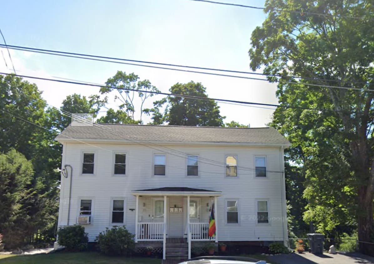
22 High St Unit 22
Westborough, MA 01581
Favorites
-
Bedrooms
4
-
Bathrooms
2
-
Square Feet
1,410 sq ft
-
Available
Available Aug 31
Highlights
- Pets Allowed
- Furnished
- Yard
- Smoke Free
22 High St Unit 22

Favorites
About This Home
12 Month Lease,
$2,450 deposit,
Available Aug 31
Location: High Street & E Main Street, Westborough, MA, 01581 Westborough center, 4bedroom/2bathroom $2450 per month Water heater, Bosch boiler heating system, window AC, laundry in unit, off street and yard parking If interested, pictures are available, please provide a brief description you and your family who will move in
22 High St is an apartment community located in Worcester County and the 01581 ZIP Code. This area is served by the Westborough School District attendance zone.
* Price shown is total price based on community-supplied monthly required fees. Excludes user-selected optional fees and variable or usage-based fees and required charges due at or prior to move-in or at move-out. Price, availability, fees, and any applicable rent special are subject to change without notice.
* Square footage definitions vary. Displayed square footage is approximate.
Apartment Features
Washer/Dryer
Air Conditioning
Dishwasher
Smoke Free
- Washer/Dryer
- Air Conditioning
- Heating
- Smoke Free
- Dishwasher
- Furnished
- Yard
Fees and Policies
The fees listed below are community-provided and may exclude utilities or add-ons. All payments are made directly to the property and are non-refundable unless otherwise specified.
- Dogs Allowed
-
Fees not specified
- Cats Allowed
-
Fees not specified
- Parking
-
Surface Lot--
Details
Utilities Included
-
Water
-
Trash Removal
-
Sewer
Property Information
-
3 units
-
Furnished Units Available
Contact
- Contact
Location
Get Directions
Situated just moments east of Worcester is the Route 9 Corridor, a large neighborhood compiled of several communities including Shrewsbury, Westborough, Northborough, and Southborough. Not only is Worcester at residents’ fingertips, but Downtown Boston is less than 40 miles east. The Route 9 Corridor is a commuter’s dream, offering easy city access and entry onto Interstates 290, 495, and 90.
The suburb is dotted with ponds, reservoirs, brooks, and rivers, providing ample outdoor recreation. Renters craving a beach day can bask on the sunny shores of Lake Chauncy Beach. Route 9 Corridor’s Prospect Park allows locals to take their dog for a stroll while Assabet Park gives children ample space to play on the playground. Those looking for winter recreation won’t want to miss the powdery slopes of Ski Ward Ski Area. No matter the season, renters settling in this diverse community can choose from gorgeous apartments ranging in price and amenities.
Learn more about living in Route 9 Corridor
Education
| Colleges & Universities | Distance | ||
|---|---|---|---|
| Colleges & Universities | Distance | ||
| Drive: | 10 min | 4.5 mi | |
| Drive: | 16 min | 8.8 mi | |
| Drive: | 16 min | 8.9 mi | |
| Drive: | 18 min | 10.0 mi |
22 High St Unit 22 is within 10 minutes or 4.5 miles from Tufts University, Grafton. It is also near Stillman College and University of Massachusetts.
Schools


Public Elementary School
Grades PK-5
430 Students
Nearby
Public Elementary School
Grades K-5
853 Students
Attendance Zone
Public Elementary School
Grades K-5
383 Students
Attendance Zone
Public Middle School
Grades 6-8
567 Students
Attendance Zone
Public High School
Grades 9-12
1,134 Students
Attendance Zone
Private Elementary & Middle School
Grades K-8
482 Students
Nearby
Private Elementary & Middle School
Grades PK-8
Nearby
Private Elementary School
Grades PK-K
92 Students
Nearby
Private High School
Grades 9-12
375 Students
Nearby
School data provided by
 The GreatSchools Rating helps parents compare schools within a state based on a variety of school quality indicators and provides a helpful picture of how effectively each school serves all of its students. Ratings are on a scale of 1 (below average) to 10 (above average) and can include test scores, college readiness, academic progress, advanced courses, equity, discipline and attendance data. We also advise parents to visit schools, consider other information on school performance and programs, and consider family needs as part of the school selection process.
View GreatSchools Rating Methodology
Data provided by GreatSchools.org © 2026. All rights reserved.
View GreatSchools Rating Methodology
Data provided by GreatSchools.org © 2026. All rights reserved.
Getting Around
 What do Walkability, Transit, Drivability, and Bikeability mean?
Walkability measures the walking distance to day-to-day needs.
Transit measures access to public transportation.
Drivability measures congestion, parking availability, and access to major roads.
Bikeability measures the suitability for cycling.
How It Works
What do Walkability, Transit, Drivability, and Bikeability mean?
Walkability measures the walking distance to day-to-day needs.
Transit measures access to public transportation.
Drivability measures congestion, parking availability, and access to major roads.
Bikeability measures the suitability for cycling.
How It Works
Moderately Walkable
Walkability
60
/ 100
Limited Public Transit
Transit
20
/ 100
Very Drivable
Drivability
80
/ 100
Fairly Bikeable
Bikeability
40
/ 100
Scores provided by
-
Soundscore™
-
/ 100
Traffic
-Airport
-Businesses
-Scores provided by
HowLoud What is a Sound Score Rating? A Sound Score Rating aggregates noise caused by vehicle traffic, airplane traffic and local sources. How It Works
Amenities
- Washer/Dryer
- Air Conditioning
- Heating
- Smoke Free
- Dishwasher
- Furnished
- Yard
22 High St Unit 22 Photos
What Are Walk Score®, Transit Score®, and Bike Score® Ratings?
Walk Score® measures the walkability of any address. Transit Score® measures access to public transit. Bike Score® measures the bikeability of any address.
What is a Sound Score Rating?
A Sound Score Rating aggregates noise caused by vehicle traffic, airplane traffic and local sources.

22 High St
Westborough, MA 01581