
$1,295
/ Month
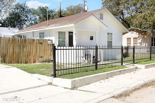
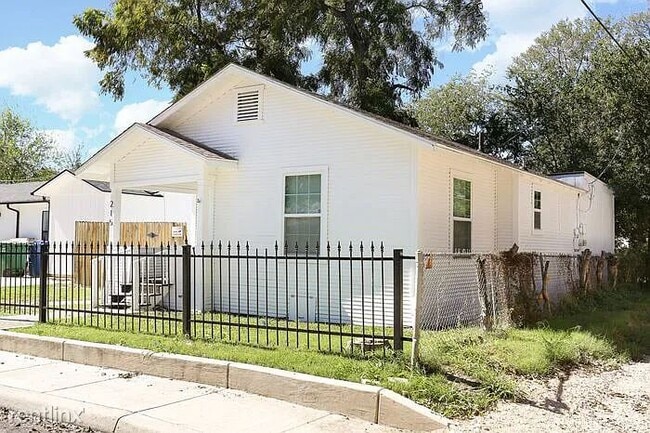
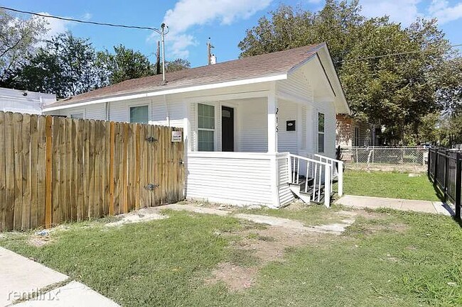
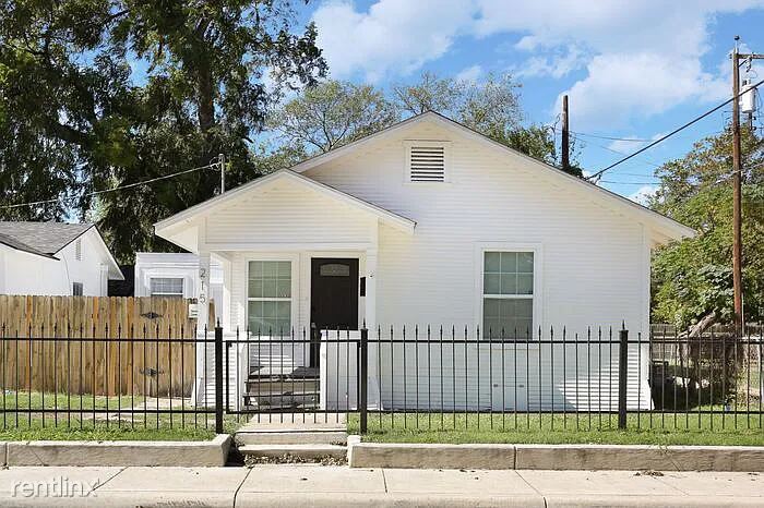
215 Crittendon Ave
San Antonio, TX 78211
Favorites
215 Crittendon Ave

Favorites
Check Back Soon for Upcoming Availability
| Beds | Baths | Average SF |
|---|---|---|
| 3 Bedrooms 3 Bedrooms 3 Br | 1 Bath 1 Bath 1 Ba | 1,120 SF |
Fees and Policies
The fees listed below are community-provided and may exclude utilities or add-ons. All payments are made directly to the property and are non-refundable unless otherwise specified.
- Dogs Allowed
-
Fees not specified
- Cats Allowed
-
Fees not specified
About This Property
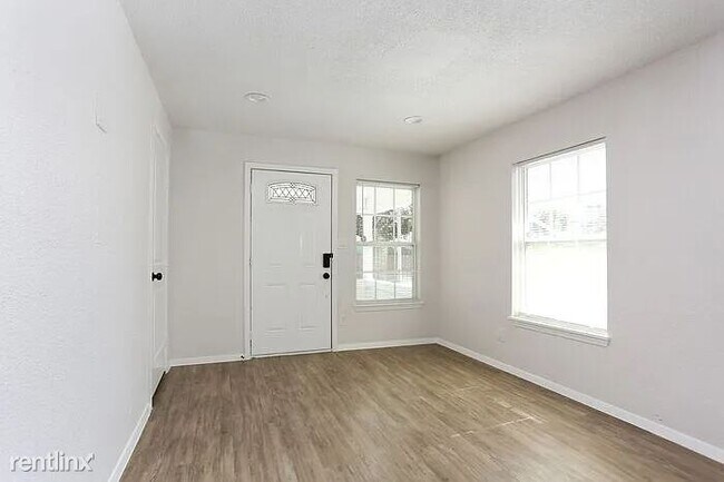
- Welcome to 215 Crittendon Ave, your ideal home in San Antonio, TX! This charming 1-story, 3-bedroom, 1-bathroom property offers the perfect blend of charm and comfort. Located in a thriving neighborhood, this home boasts a modest layout with wood grain laminate floors, modern finishes throughout, and a newly renovated kitchen with stainless steel appliances, stylish white cabinetry, plenty of storage space, and a breakfast bar for gathering around. Don't miss out on your chance to lease this gem. ** In person tours required ** all renters are enrolled in the resident benefits package (inquire for more details) ** Pet rent is based on the petscreening FIDO score (RLNE8128157) Other Amenities: Unfurnished (Unfurnished), Parking (1 Space), Smoke Free (Smoke Free). Appliances: Air Conditioning (Air Conditioning), Refrigerator (Fridge), Washer & Dryer Hookup (wash/dry connections). Pet policies: Small Dogs Allowed (Cats & Dogs), Cats Allowed (Cats & Dogs).
215 Crittendon Ave is a house located in Bexar County and the 78211 ZIP Code. This area is served by the South San Antonio Independent School District attendance zone.
Unique Features
- Small Dogs Allowed - Cats & Dogs, Cats Allowed - Cats & Dogs
House Features
- Air Conditioning
215 Crittendon Ave,
San Antonio,
TX
78211
Quintana Community borders Lackland Air Force Base in southwest San Antonio. The residential sections are interspersed with industry, containing such businesses as Fiesta Warehousing & Distribution, GBW Railcar Services, and CIG Logistics Metal Yard. Several restaurants, shops, and other businesses are located along Quintana Road. A large shopping area is located off Somerset Road and Military Drive, including Sam’s Club, Burlington, and Target. This is also the location of Southwest General Hospital.
Normoyle Park provides a community center, tennis courts, ball fields, a swimming pool, and a basketball court. This park is located off Culberson Avenue. Several other parks are located within a short distance of Quintana, including the 505-acre Pearsall Park, which is adjacent to Quintana on the southwest side. This park includes a playground, the Pearsall Water-Skate Park, picnic areas, and a dog park.
Learn more about living in QuintanaBelow are rent ranges for similar nearby apartments
Amenities
- Air Conditioning
- Small Dogs Allowed - Cats & Dogs, Cats Allowed - Cats & Dogs
Education
| Colleges & Universities | Distance | ||
|---|---|---|---|
| Colleges & Universities | Distance | ||
| Walk: | 18 min | 1.0 mi | |
| Drive: | 9 min | 4.2 mi | |
| Drive: | 10 min | 4.5 mi | |
| Drive: | 15 min | 7.3 mi |
215 Crittendon Ave is within 18 minutes or 1.0 mile from St. Philip's College, SWC. It is also near Palo Alto College and Our Lady of the Lake Univ..
Schools

Public Elementary School
Grades PK-5
423 Students
Nearby
Public Middle School
Grades 6-8
432 Students
Attendance Zone
Public High School
Grades 9-12
1,786 Students
Attendance Zone
Private Elementary & Middle School
Grades PK-8
354 Students
Nearby
Private Elementary, Middle & High School
Grades 2-12
Nearby
School data provided by
 The GreatSchools Rating helps parents compare schools within a state based on a variety of school quality indicators and provides a helpful picture of how effectively each school serves all of its students. Ratings are on a scale of 1 (below average) to 10 (above average) and can include test scores, college readiness, academic progress, advanced courses, equity, discipline and attendance data. We also advise parents to visit schools, consider other information on school performance and programs, and consider family needs as part of the school selection process.
View GreatSchools Rating Methodology
Data provided by GreatSchools.org © 2026. All rights reserved.
View GreatSchools Rating Methodology
Data provided by GreatSchools.org © 2026. All rights reserved.
Walkability Near 215 Crittendon Ave San Antonio, TX 78211
Getting Around
 What do Walkability, Transit, Drivability, and Bikeability mean?
Walkability measures the walking distance to day-to-day needs.
Transit measures access to public transportation.
Drivability measures congestion, parking availability, and access to major roads.
Bikeability measures the suitability for cycling.
How It Works
What do Walkability, Transit, Drivability, and Bikeability mean?
Walkability measures the walking distance to day-to-day needs.
Transit measures access to public transportation.
Drivability measures congestion, parking availability, and access to major roads.
Bikeability measures the suitability for cycling.
How It Works
Fairly Walkable
Walkability
40
/ 100
Limited Public Transit
Transit
30
/ 100
Very Drivable
Drivability
80
/ 100
Fairly Bikeable
Bikeability
40
/ 100
Scores provided by
-
Soundscore™
-
/ 100
Traffic
-Airport
-Businesses
-Scores provided by
HowLoud What is a Sound Score Rating? A Sound Score Rating aggregates noise caused by vehicle traffic, airplane traffic and local sources. How It WorksYou May Also Like
-
The Arbor at Riverstone Rental Homes
5512 Trinity Run
San Antonio, TX 78253
$2,035 - $2,535 Total Monthly Price
3-4 Br 12 Month Lease 15.6 mi
-
Tricon Trails at Culebra
14303 Palm Rdg
San Antonio, TX 78253
$1,729 - $2,755
3-4 Br 16.4 mi
-
Alamar
4003 Alamar Rdg
San Antonio, TX 78259
$2,295 - $2,745
3-4 Br 18.9 mi
Similar Rentals Nearby
-
-
-
-
-
-
1 / 41
 3 Beds$2,448+4 Beds$2,799+Total Monthly PriceTotal Monthly Price NewPrices include base rent and required monthly fees of $249. Variable costs based on usage may apply.Base Rent:3 Beds$2,100+4 Beds$2,550+2 Months Free
Pets Allowed Pool Dishwasher Kitchen Clubhouse Maintenance on site CableReady
-
-
-
3 Beds$2,253+4 Beds$2,873Total Monthly PriceTotal Monthly Price NewPrices include base rent and required monthly fees of $119. Variable costs based on usage may apply.Base Rent:3 Beds$2,133+4 Beds$2,7531 Month Free
-


What Are Walk Score®, Transit Score®, and Bike Score® Ratings?
Walk Score® measures the walkability of any address. Transit Score® measures access to public transit. Bike Score® measures the bikeability of any address.
What is a Sound Score Rating?
A Sound Score Rating aggregates noise caused by vehicle traffic, airplane traffic and local sources.
215 Crittendon Ave
San Antonio, TX 78211