
$2,800
/ Month
2108 Hermia St
Austin, TX 78741
Today
|
Edit
Favorites
512-203-1912
-
Bedrooms
3
-
Bathrooms
3
-
Square Feet
2,035 sq ft
-
Available
Available Now
Highlights
- Gated Community
- Vaulted Ceiling
- Wood Flooring
- Main Floor Primary Bedroom
- Private Yard
- Multiple Living Areas
2108 Hermia St

Favorites
About This Home
Available Now
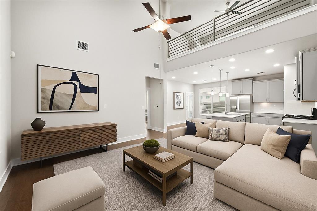
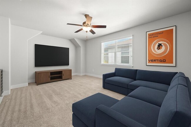
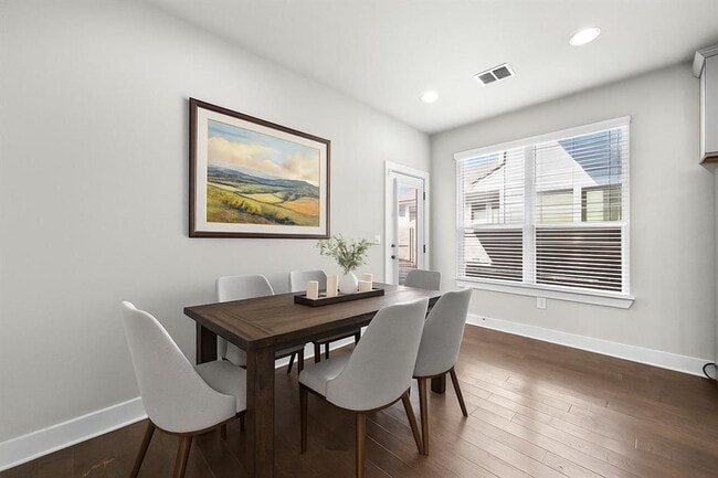
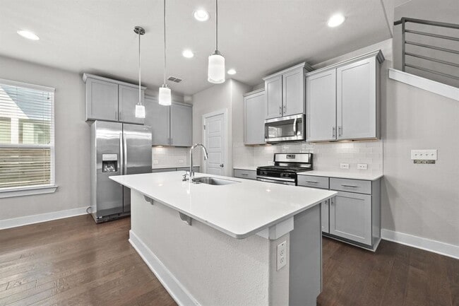
Welcome to Eastwood at Riverside, a charming gated community in vibrant East Austin. Here, modern stand-alone condos offer the feel of a private home—no shared walls, your own fenced yard, and plenty of room to relax. The neighborhood even includes a fenced dog park, perfect for giving your pup space to explore and play. Located on Hermia St., this home features a coveted floor plan with the primary bedroom situated on the main level. This home is also conveniently located right across from guest parking to accommodate any visitors. You’ll also find an indoor utility room equipped with a full-size washer and dryer for easy everyday living. The sleek, contemporary kitchen boasts a spacious quartz island and breakfast bar, stainless steel appliances—including a refrigerator, gas range, microwave, and farmhouse sink—plus generous cabinet storage and a pantry. Enjoy wood flooring in the living and dining areas, tile in the bathrooms, and soft carpeting in the bedrooms. Upstairs, a roomy loft provides flexible space for work, play, or relaxation. The location is hard to beat—major employers like Oracle on Lakeshore Drive and the Austin-Bergstrom International Airport are just minutes away. You can walk to Ani’s Day and Night coffeeshop, or take a quick rideshare to local favorites like Meanwhile Brewing, Radio East, and Pinthouse Brewery. You're also a short drive from the lively SoCo, South First, and South Lamar districts, along with all the energy of Downtown Austin.
2108 Hermia St is a house located in Travis County and the 78741 ZIP Code. This area is served by the Del Valle Independent attendance zone.
* Price shown is base rent. Excludes user-selected optional fees and variable or usage-based fees and required charges due at or prior to move-in or at move-out. Price, availability, fees, and any applicable rent special are subject to change without notice.
* Square footage definitions vary. Displayed square footage is approximate.
Home Details
Home Type
Single Family Detached Home
Year Built
Built in 2017
Accessible Home Design
Stepless Entry
Bedrooms and Bathrooms
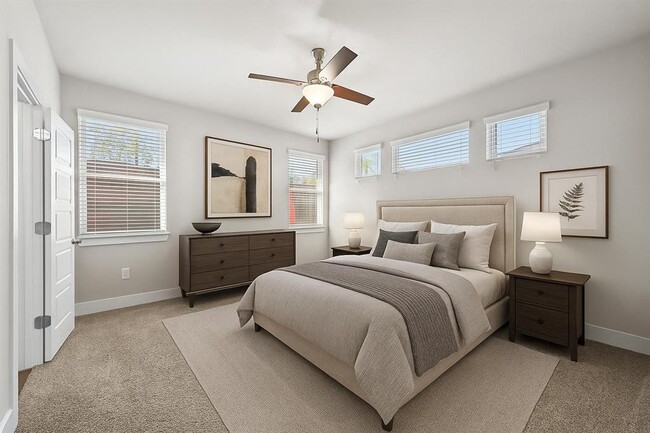
3 Bedrooms | 1 Primary Bedroom on Main
Walk-In Closet
2.5 Bathrooms
Flooring
Wood
Tile
Carpet
Home Design
Brick Exterior Construction
Masonry Siding
Composition Roof
HardiePlank Type
Slab Foundation
Home Security
Prewired Security
Fire and Smoke Detector
Interior Spaces
Vaulted Ceiling
Multiple Living Areas
Recessed Lighting
Entrance Foyer
Ceiling Fan
2,035 Sq Ft Home
2-Story Property
Window Treatments
Kitchen
Farmhouse Sink
Stainless Steel Appliances
Breakfast Bar
Free-Standing Gas Range
Microwave
Dishwasher
Disposal
Laundry
Dryer
Washer
Listing and Financial Details
Security Deposit $2,800
$85 Application Fee
Assessor Parcel Number 03121605380000
Tenant pays for all utilities, electricity, gas, internet, sewer, trash collection, water
The owner pays for association fees, taxes
Lot Details
6,556 Sq Ft Lot
Private Yard
Interior Lot
Wrought Iron Fence
East Facing Home
Wood Fence
Level Lot
Dense Growth Of Small Trees
Outdoor Features
Patio
Parking
2 Car Attached Garage
Single Garage Door
Front Facing Garage
Garage Door Opener
Schools
Smith Elementary School
Ojeda Middle School
Del Valle High School
Utilities
Central Heating and Cooling System
High Speed Internet
Cable TV Available
Underground Utilities
Views
Neighborhood Views
Community Details
Amenities
Common Area
Overview
Property has a Home Owners Association
Built by Milestone Community Builders
Eastwood At Riverside Subdivision
Pet Policy
Dogs and Cats Allowed
Breed Restrictions
Limit on the number of pets
Pet Deposit $500
Recreation
Dog Park
Security
Gated Community
Fees and Policies
The fees below are based on community-supplied data and may exclude additional fees and utilities.
-
Dogs
-
Allowed
-
-
Cats
-
Allowed
-
Property Fee Disclaimer: Based on community-supplied data and independent market research. Subject to change without notice. May exclude fees for mandatory or optional services and usage-based utilities.
Contact
- Listed by Debbie Barrera | Christie's Int'l Real Estate
- Phone Number
- Website View Property Website
- Contact
-
Source
 Austin Board of REALTORS®
The information included in this listing is provided exclusively for consumers’ personal, non-commercial use and may not be used for any purpose other than to identify prospective properties consumers may be interested in purchasing. The information on each listing is furnished by the owner and deemed reliable to the best of his/her knowledge, but should be verified by the purchaser. ABoR, ACTRIS and Estately assume no responsibility for typographical errors, misprints or misinformation. This property listing is offered without respect to any protected classes in accordance with the law. Copyright © 2025.
Location
Get Directions
Amenities
- Dishwasher
- Disposal
- Microwave
- Refrigerator
- Hardwood Floors
- Carpet
- Tile Floors
Nestled just six miles southeast of Downtown Austin, Montopolis is a centrally located neighborhood between Highway 183 and Interstate 71. Commuter benefits are many in this Texas suburb, including its proximity to the Austin-Bergstrom International Airport. Because of its ideal location, Montopolis is growing in popularity, especially with commuters and renters looking or quick access to the University of Texas at Austin, located just six miles northwest. Rentals in Montopolis vary greatly between apartments, condos, and houses, so there is something for everyone.
Residents of Montopolis have their choice of outdoor recreation, from the Riverside Golf Course and the Roy G. Guerrero Colorado River Metro Park to the Colorado River Wildlife Sanctuary and the Montopolis Neighborhood Park. Locals enjoy the natural appeal, along with the walking, biking, and running trails in these community spaces.
Learn more about living in Montopolis
Education
| Colleges & Universities | Distance | ||
|---|---|---|---|
| Colleges & Universities | Distance | ||
| Drive: | 6 min | 2.1 mi | |
| Drive: | 10 min | 5.1 mi | |
| Drive: | 8 min | 5.2 mi | |
| Drive: | 12 min | 8.3 mi |
2108 Hermia St is within 6 minutes or 2.1 miles from Austin C.C., Riverside Campus. It is also near St. Edward's University and Austin C.C., Eastview Campus.
Schools


Public Elementary School
Grades PK-5
508 Students
Attendance Zone
Public Middle School
Grades 6-8
821 Students
Attendance Zone
Public Middle & High School
Grades 8-12
3,460 Students
Attendance Zone
Private Elementary & Middle School
Grades PK-8
103 Students
Nearby
Private Elementary & Middle School
Grades PK-8
224 Students
Nearby
Private High School
Grades 9-12
150 Students
Nearby
School data provided by
 The GreatSchools Rating helps parents compare schools within a state based on a variety of school quality indicators and provides a helpful picture of how effectively each school serves all of its students. Ratings are on a scale of 1 (below average) to 10 (above average) and can include test scores, college readiness, academic progress, advanced courses, equity, discipline and attendance data. We also advise parents to visit schools, consider other information on school performance and programs, and consider family needs as part of the school selection process.
View GreatSchools Rating Methodology
Data provided by GreatSchools.org © 2026. All rights reserved.
View GreatSchools Rating Methodology
Data provided by GreatSchools.org © 2026. All rights reserved.
Transportation options available in Austin include M L King Jr Station, located 6.1 miles from 2108 Hermia St. 2108 Hermia St is near Austin-Bergstrom International, located 7.0 miles or 17 minutes away.
| Transit / Subway | Distance | ||
|---|---|---|---|
| Transit / Subway | Distance | ||
| Drive: | 12 min | 6.1 mi | |
| Drive: | 10 min | 6.8 mi | |
| Drive: | 11 min | 7.5 mi | |
| Drive: | 16 min | 11.5 mi | |
| Drive: | 19 min | 12.4 mi |
| Commuter Rail | Distance | ||
|---|---|---|---|
| Commuter Rail | Distance | ||
|
|
Drive: | 14 min | 8.4 mi |
|
|
Drive: | 37 min | 30.4 mi |
|
|
Drive: | 48 min | 41.2 mi |
| Airports | Distance | ||
|---|---|---|---|
| Airports | Distance | ||
|
Austin-Bergstrom International
|
Drive: | 17 min | 7.0 mi |
Time and distance from 2108 Hermia St.
| Shopping Centers | Distance | ||
|---|---|---|---|
| Shopping Centers | Distance | ||
| Drive: | 5 min | 2.0 mi | |
| Drive: | 7 min | 2.4 mi | |
| Drive: | 6 min | 2.7 mi |
2108 Hermia St has 3 shopping centers within 2.7 miles, which is about a 6-minute drive. The miles and minutes will be for the farthest away property.
| Parks and Recreation | Distance | ||
|---|---|---|---|
| Parks and Recreation | Distance | ||
|
Lady Bird Lake
|
Drive: | 8 min | 3.4 mi |
|
Blunn Creek Nature Preserve
|
Drive: | 8 min | 4.2 mi |
|
Onion Creek Greenbelt Park
|
Drive: | 13 min | 5.1 mi |
|
Boggy Creek Greenbelt
|
Drive: | 11 min | 5.2 mi |
|
McKinney Falls State Park
|
Drive: | 13 min | 5.4 mi |
2108 Hermia St has 5 parks within 5.4 miles, including Lady Bird Lake, Blunn Creek Nature Preserve, and McKinney Falls State Park.
| Hospitals | Distance | ||
|---|---|---|---|
| Hospitals | Distance | ||
| Drive: | 8 min | 5.5 mi | |
| Drive: | 11 min | 7.4 mi | |
| Drive: | 11 min | 7.5 mi |
2108 Hermia St has 3 hospitals within 7.5 miles, the nearest is St. David's South Austin Medical Center which is 5.5 miles away and a 8 minute drive.
| Military Bases | Distance | ||
|---|---|---|---|
| Military Bases | Distance | ||
| Drive: | 79 min | 65.4 mi | |
| Drive: | 108 min | 92.9 mi |
2108 Hermia St is 65.4 miles from Randolph Air Force Base, and is convenient to other military bases, including Camp Bullis Military Training Reservation.
You May Also Like
Similar Rentals Nearby
-
-

-
1 / 53

-
-
1 / 34

-
-
-

-

-


What Are Walk Score®, Transit Score®, and Bike Score® Ratings?
Walk Score® measures the walkability of any address. Transit Score® measures access to public transit. Bike Score® measures the bikeability of any address.
What is a Sound Score Rating?
A Sound Score Rating aggregates noise caused by vehicle traffic, airplane traffic and local sources

2108 Hermia St
Austin, TX 78741