
The Alamitos
101 Alamitos Ave,
Long Beach, CA 90802
$2,175 - $5,415
Studio - 2 Beds
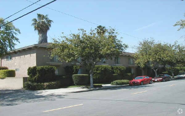

Discover your new place at 2041 San Anseline Ave in Long Beach, CA. You'll find this community in the Los Altos area of Long Beach. The leasing staff is ready for you to come see our property. It's time to love where you live. Stop by for a visit today.
2041 San Anseline Ave is an apartment community located in Los Angeles County and the 90815 ZIP Code. This area is served by the Long Beach Unified attendance zone.
Located 28 miles outside of Los Angeles in east Long Beach is Los Altos, a family-friendly suburbia. This tree-lined neighborhood offers its residents a tranquil oasis within minutes of Downtown Long Beach. Shopping enthusiasts can head to Los Altos Shopping Center which houses popular retail stores such as Target, Trader Joe's, and T.J. Maxx.
Locals enjoy visiting the popular Walter Pyramid, the iconic 18-story blue pyramid-shaped stadium located on the California State University Long Beach campus. Other outdoor entertainment includes Whaley Park Community Center, home to baseball fields, basketball courts, volleyball, and even a roller hockey rink. Whether you enjoy the great outdoors, shopping or sightseeing, you'll delight in Los Altos. Stucco, ranch-style homes, and apartments are available to rent.
Learn more about living in Los Altos| Colleges & Universities | Distance | ||
|---|---|---|---|
| Colleges & Universities | Distance | ||
| Drive: | 3 min | 1.3 mi | |
| Drive: | 8 min | 3.6 mi | |
| Drive: | 9 min | 3.8 mi | |
| Drive: | 15 min | 8.6 mi |


Transportation options available in Long Beach include Pacific Coast Highway Station, located 4.4 miles from 2041 San Anseline Ave. 2041 San Anseline Ave is near Long Beach (Daugherty Field), located 4.7 miles or 8 minutes away, and John Wayne/Orange County, located 18.1 miles or 24 minutes away.
| Transit / Subway | Distance | ||
|---|---|---|---|
| Transit / Subway | Distance | ||
|
|
Drive: | 10 min | 4.4 mi |
|
|
Drive: | 11 min | 4.9 mi |
|
|
Drive: | 12 min | 5.2 mi |
|
|
Drive: | 13 min | 5.5 mi |
|
|
Drive: | 10 min | 5.9 mi |
| Commuter Rail | Distance | ||
|---|---|---|---|
| Commuter Rail | Distance | ||
|
|
Drive: | 23 min | 13.3 mi |
|
|
Drive: | 21 min | 13.4 mi |
|
|
Drive: | 27 min | 16.7 mi |
|
|
Drive: | 26 min | 17.1 mi |
| Drive: | 25 min | 17.6 mi |
| Airports | Distance | ||
|---|---|---|---|
| Airports | Distance | ||
|
Long Beach (Daugherty Field)
|
Drive: | 8 min | 4.7 mi |
|
John Wayne/Orange County
|
Drive: | 24 min | 18.1 mi |
Time and distance from 2041 San Anseline Ave.
| Shopping Centers | Distance | ||
|---|---|---|---|
| Shopping Centers | Distance | ||
| Walk: | 5 min | 0.3 mi | |
| Walk: | 7 min | 0.4 mi | |
| Walk: | 16 min | 0.9 mi |
| Parks and Recreation | Distance | ||
|---|---|---|---|
| Parks and Recreation | Distance | ||
|
Earl Burns Miller Japanese Garden
|
Walk: | 14 min | 0.7 mi |
|
El Dorado East Regional Park
|
Drive: | 6 min | 2.1 mi |
|
Colorado Lagoon
|
Drive: | 6 min | 2.5 mi |
|
El Dorado Nature Center
|
Drive: | 5 min | 2.7 mi |
|
Los Cerritos Wetlands Trust
|
Drive: | 6 min | 3.4 mi |
| Hospitals | Distance | ||
|---|---|---|---|
| Hospitals | Distance | ||
| Drive: | 5 min | 2.5 mi | |
| Drive: | 7 min | 4.3 mi | |
| Drive: | 9 min | 4.6 mi |
| Military Bases | Distance | ||
|---|---|---|---|
| Military Bases | Distance | ||
| Drive: | 14 min | 8.0 mi | |
| Drive: | 26 min | 12.3 mi |
What Are Walk Score®, Transit Score®, and Bike Score® Ratings?
Walk Score® measures the walkability of any address. Transit Score® measures access to public transit. Bike Score® measures the bikeability of any address.
What is a Sound Score Rating?
A Sound Score Rating aggregates noise caused by vehicle traffic, airplane traffic and local sources

2041 San Anseline Ave
Long Beach, CA 90815


