$2,550
/ Month
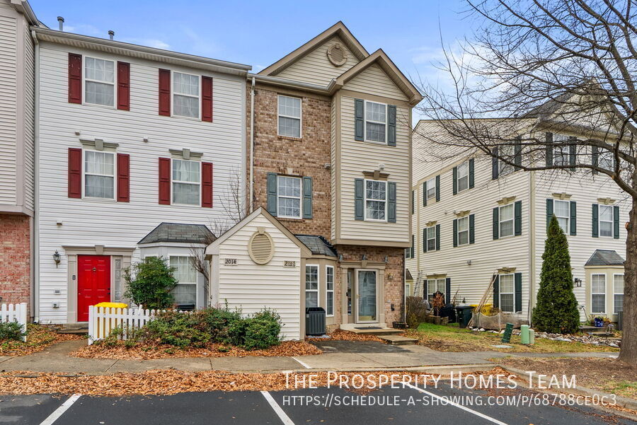
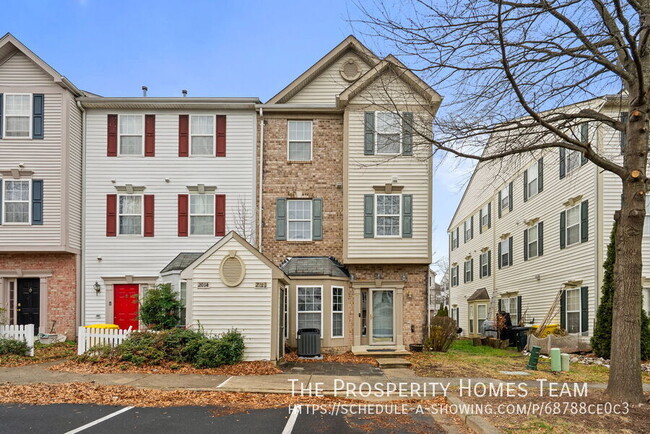
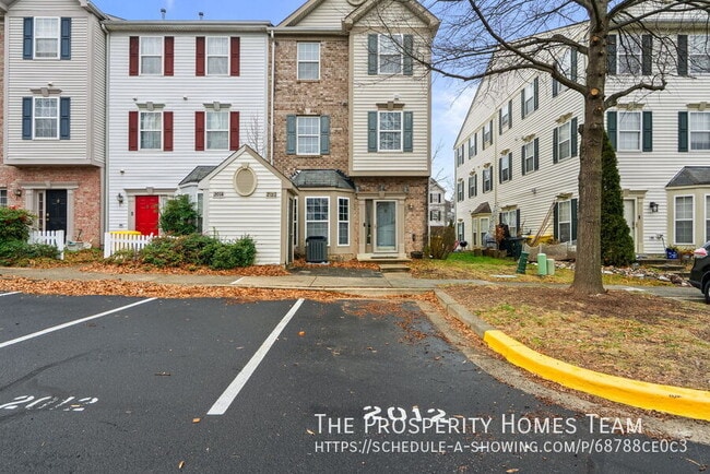
2012 Cramer Point Ct
Odenton, MD 21113
Today
|
Edit
Favorites
-
Bedrooms
3
-
Bathrooms
2.5
-
Square Feet
1,612 sq ft
-
Available
Available Now
2012 Cramer Point Ct

Favorites
About This Home
Available Now
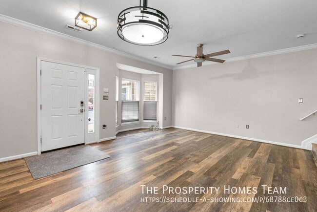
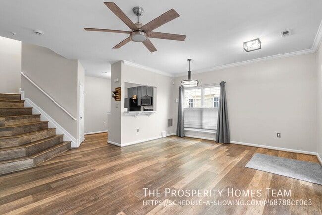
Multi-level townhome-style home located in a quiet Odenton community with a traditional brick and siding exterior and private front entry. Parking is conveniently located just steps from the door. The main living level features an open layout with wide-plank flooring, crown molding, updated light fixtures, ceiling fans, and consistent natural light throughout. Large windows and a bay window provide brightness while maintaining privacy. The kitchen has been updated with quartz countertops, stainless steel appliances, modern cabinetry, and a pass-through breakfast bar that keeps the space open and functional. The home’s multi-level design offers separation between living and sleeping areas, making it well-suited for work-from-home needs, guests, or shared living arrangements. Neutral finishes throughout create a clean, move-in-ready feel. Conveniently located near Fort Meade, MARC train service, major commuter routes, shopping, and dining.
2012 Cramer Point Ct is a townhome located in Anne Arundel County and the 21113 ZIP Code. This area is served by the Anne Arundel County Public Schools attendance zone.
* Price shown is base rent. Excludes user-selected optional fees and variable or usage-based fees and required charges due at or prior to move-in or at move-out. Price, availability, fees, and any applicable rent special are subject to change without notice.
* Square footage definitions vary. Displayed square footage is approximate.
Townhome Features
Washer/Dryer
Air Conditioning
Dishwasher
Microwave
- Washer/Dryer
- Air Conditioning
- Dishwasher
- Disposal
- Microwave
- Refrigerator
Contact
- Listed by The Prosperity Homes Team
- Contact
Location
Get Directions
Amenities
- Washer/Dryer
- Air Conditioning
- Dishwasher
- Disposal
- Microwave
- Refrigerator
Situated in Anne Arundel County, Odenton is centrally located between Annapolis, Washington D.C., and Baltimore. The city is continuously growing in population, largely due to its proximity to Fort George G. Meade military base and the developing Piney Orchard neighborhood.
In Odenton, you’ll discover a lot of great shopping centers like Waugh Chapel Towne Centre. Hikers will enjoy the plethora of trails that reside within the community, including Little Patuxent River Trail, Wild Turkey Way, and Merganser Pond Trail, among others. Midland Park is a large green space just minutes from Bowie State University. This Baltimore suburb contains highly rated public schools, plus access to Interstate 97 and Odenton Station.
Learn more about living in Odenton
Education
| Colleges & Universities | Distance | ||
|---|---|---|---|
| Colleges & Universities | Distance | ||
| Drive: | 24 min | 14.2 mi | |
| Drive: | 25 min | 14.7 mi | |
| Drive: | 27 min | 15.8 mi | |
| Drive: | 28 min | 16.7 mi |
2012 Cramer Point Ct is within 24 minutes or 14.2 miles from UMBC. It is also near CCBC Cantonsville and Anne Arundel Community College.
Schools


Public Elementary School
Grades PK-5
508 Students
Attendance Zone
Public Middle School
Grades 6-8
878 Students
Attendance Zone
Public High School
Grades 9-12
2,330 Students
Attendance Zone
Private Elementary, Middle & High School
Grades 2-12
7 Students
Nearby
Private Elementary, Middle & High School
Grades PK-12
181 Students
Nearby
School data provided by
 The GreatSchools Rating helps parents compare schools within a state based on a variety of school quality indicators and provides a helpful picture of how effectively each school serves all of its students. Ratings are on a scale of 1 (below average) to 10 (above average) and can include test scores, college readiness, academic progress, advanced courses, equity, discipline and attendance data. We also advise parents to visit schools, consider other information on school performance and programs, and consider family needs as part of the school selection process.
View GreatSchools Rating Methodology
Data provided by GreatSchools.org © 2025. All rights reserved.
View GreatSchools Rating Methodology
Data provided by GreatSchools.org © 2025. All rights reserved.
Transportation options available in Odenton include Dorsey, located 7.7 miles from 2012 Cramer Point Ct. 2012 Cramer Point Ct is near Baltimore/Washington International Thurgood Marshall, located 9.6 miles or 19 minutes away, and Ronald Reagan Washington Ntl, located 31.2 miles or 50 minutes away.
| Transit / Subway | Distance | ||
|---|---|---|---|
| Transit / Subway | Distance | ||
|
|
Drive: | 15 min | 7.7 mi |
|
|
Drive: | 18 min | 9.5 mi |
|
|
Drive: | 20 min | 9.8 mi |
|
|
Drive: | 18 min | 10.1 mi |
|
|
Drive: | 19 min | 10.4 mi |
| Commuter Rail | Distance | ||
|---|---|---|---|
| Commuter Rail | Distance | ||
|
|
Drive: | 7 min | 2.8 mi |
|
|
Drive: | 12 min | 5.5 mi |
|
|
Drive: | 13 min | 7.7 mi |
| Drive: | 15 min | 7.7 mi | |
| Drive: | 15 min | 7.8 mi |
| Airports | Distance | ||
|---|---|---|---|
| Airports | Distance | ||
|
Baltimore/Washington International Thurgood Marshall
|
Drive: | 19 min | 9.6 mi |
|
Ronald Reagan Washington Ntl
|
Drive: | 50 min | 31.2 mi |
Time and distance from 2012 Cramer Point Ct.
| Shopping Centers | Distance | ||
|---|---|---|---|
| Shopping Centers | Distance | ||
| Walk: | 11 min | 0.6 mi | |
| Walk: | 15 min | 0.8 mi | |
| Drive: | 6 min | 2.6 mi |
2012 Cramer Point Ct has 3 shopping centers within 2.6 miles, which is about a 6-minute drive. The miles and minutes will be for the farthest away property.
| Parks and Recreation | Distance | ||
|---|---|---|---|
| Parks and Recreation | Distance | ||
|
Patuxent Research Refuge - North Tract
|
Drive: | 12 min | 5.4 mi |
|
Kinder Farm Park
|
Drive: | 24 min | 13.0 mi |
|
Patuxent Research Refuge - South Tract
|
Drive: | 25 min | 13.6 mi |
2012 Cramer Point Ct has 3 parks within 13.6 miles, including Patuxent Research Refuge - North Tract, Kinder Farm Park, and Patuxent Research Refuge - South Tract.
| Hospitals | Distance | ||
|---|---|---|---|
| Hospitals | Distance | ||
| Drive: | 18 min | 9.3 mi | |
| Drive: | 22 min | 11.4 mi |
2012 Cramer Point Ct is 9.3 miles from University of Maryland Baltimore Washington Medical Center, and is convenient to other hospitals, including Laurel Regional Medical Center.
| Military Bases | Distance | ||
|---|---|---|---|
| Military Bases | Distance | ||
| Drive: | 6 min | 2.3 mi |
2012 Cramer Point Ct is 2.3 miles and a 6 minute drive from Fort George Meade.
You May Also Like
Similar Rentals Nearby


What Are Walk Score®, Transit Score®, and Bike Score® Ratings?
Walk Score® measures the walkability of any address. Transit Score® measures access to public transit. Bike Score® measures the bikeability of any address.
What is a Sound Score Rating?
A Sound Score Rating aggregates noise caused by vehicle traffic, airplane traffic and local sources

2012 Cramer Point Ct
Odenton, MD 21113