
$2,995 / Month
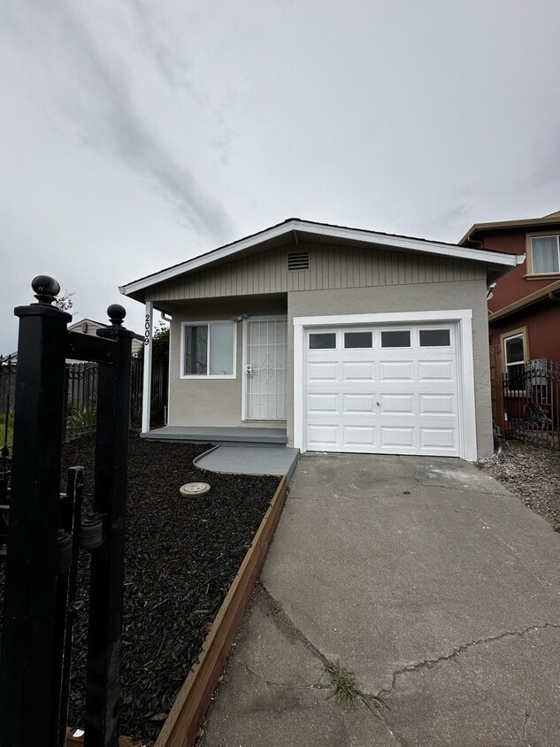
2009 Cutting Blvd
Richmond, CA 94804
Today
Favorites
510-530-2050
-
Bedrooms
3
-
Bathrooms
1.5
-
Square Feet
923 sq ft
-
Available
Available Now
2009 Cutting Blvd

Favorites
About This Home
$2,995 deposit,
Available Now
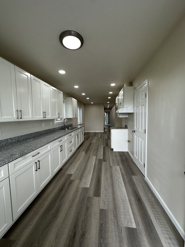
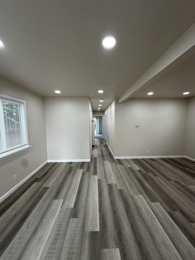
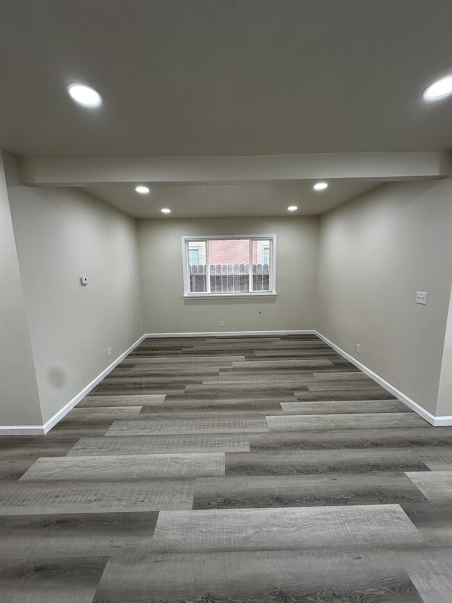
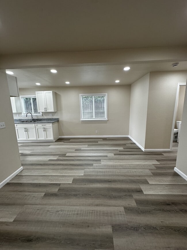
Beautifully Renovated Home in the Coronado Area Welcome to this fully renovated gem nestled in the desirable Coronado neighborhood. This charming home combines modern upgrades with comfort and convenience—perfect for families, professionals, or anyone looking for a move-in-ready space. Key Features: -Modern Galley Kitchen – Enjoy cooking in a sleek, updated kitchen featuring brand-new stainless steel appliances, stylish quartz countertops, and contemporary cabinetry. -Open Living & Dining – The spacious open-concept layout seamlessly connects the kitchen to the living and dining areas, ideal for entertaining or relaxing. -Three Cozy Bedrooms – Each room is filled with natural light and offers brand-new carpeting, creating a warm and inviting atmosphere. -Updated Bathrooms – A full bathroom with modern fixtures plus a convenient half bath with washer and electric dryer hookups. -Stylish Finishes Throughout – Laminate flooring, all-new lighting, updated windows, and custom window coverings add to the home's fresh, modern feel. -Attached Garage & Fenced Yard – Includes a single-car garage with manual door and a private fenced yard, perfect for pets, kids, or gardening. Prime Location: Just minutes from BART, I-580/I-80, and close to Marina Bay, local schools, Richmond City Center, Harbor Gate Shopping Center, and more. Whether commuting or exploring local amenities, everything you need is nearby. Don't miss your chance to rent this beautifully updated home in one of Richmond's most convenient neighborhoods!
2009 Cutting Blvd is a house located in Contra Costa County and the 94804 ZIP Code. This area is served by the West Contra Costa Unified attendance zone.
* Price shown is base rent and may not include non-optional fees and utilities.
Price, availability, fees, and any applicable rent special are subject to change without notice.
* Square footage definitions vary. Displayed square footage is approximate.
House Features
- Range
- Refrigerator
- Yard
Fees and Policies
The fees below are based on community-supplied data and may exclude additional fees and utilities.
- Parking
-
Garage--
Contact
- Listed by Marquardt Property Management
- Phone Number
- Contact
Location
Get Directions
Amenities
- Range
- Refrigerator
- Yard
The Coronado neighborhood of Richmond, California has a small-town, old school vibe in the Bay Area. A historic naval town perched just north of Berkeley, Richmond has escaped much of the pronounced price hikes of other Bay Area cities like Oakland.
Coronado hosts a great deal of cultural diversity. Restaurants, parks and more lie at arm's length for residents here, and access to Oakland, Berkeley and other Bay Area cities is a snap. Coronado can be found just south of downtown Richmond, less than a mile north of Marina Bay and the Rosie the Riveter/World War IIHome Front historical park. Residents have easy access to the waterfront and the panoramic views provided by the Richmond Bay Trail.
Learn more about living in Coronado
Education
| Colleges & Universities | Distance | ||
|---|---|---|---|
| Colleges & Universities | Distance | ||
| Drive: | 7 min | 3.7 mi | |
| Drive: | 13 min | 7.7 mi | |
| Drive: | 17 min | 8.8 mi | |
| Drive: | 14 min | 10.4 mi |
2009 Cutting Blvd is within 7 minutes or 3.7 miles from Contra Costa College. It is also near Berkeley City College and UC Berkeley.
Schools


Public Elementary School
Grades K-5
270 Students
Nearby
Public Elementary School
Grades K-6
329 Students
Attendance Zone
Public Middle School
Grades 7-8
404 Students
Attendance Zone
Public High School
Grades 9-12
823 Students
Attendance Zone
Private Elementary, Middle & High School
Grades PK-12
Nearby
School data provided by
 The GreatSchools Rating helps parents compare schools within a state based on a variety of school quality indicators and provides a helpful picture of how effectively each school serves all of its students. Ratings are on a scale of 1 (below average) to 10 (above average) and can include test scores, college readiness, academic progress, advanced courses, equity, discipline and attendance data. We also advise parents to visit schools, consider other information on school performance and programs, and consider family needs as part of the school selection process.
View GreatSchools Rating Methodology
Data provided by GreatSchools.org © 2025. All rights reserved.
View GreatSchools Rating Methodology
Data provided by GreatSchools.org © 2025. All rights reserved.
Transportation options available in Richmond include Richmond Station, located 1.2 miles from 2009 Cutting Blvd. 2009 Cutting Blvd is near Metro Oakland International, located 20.8 miles or 28 minutes away, and San Francisco International, located 28.4 miles or 40 minutes away.
| Transit / Subway | Distance | ||
|---|---|---|---|
| Transit / Subway | Distance | ||
|
|
Drive: | 3 min | 1.2 mi |
|
|
Drive: | 5 min | 2.1 mi |
|
|
Drive: | 5 min | 2.1 mi |
|
|
Drive: | 7 min | 4.4 mi |
|
|
Drive: | 11 min | 7.1 mi |
| Commuter Rail | Distance | ||
|---|---|---|---|
| Commuter Rail | Distance | ||
| Drive: | 3 min | 1.2 mi | |
|
|
Drive: | 9 min | 6.4 mi |
|
|
Drive: | 11 min | 8.2 mi |
| Drive: | 15 min | 9.6 mi | |
| Drive: | 15 min | 10.5 mi |
| Airports | Distance | ||
|---|---|---|---|
| Airports | Distance | ||
|
Metro Oakland International
|
Drive: | 28 min | 20.8 mi |
|
San Francisco International
|
Drive: | 40 min | 28.4 mi |
Time and distance from 2009 Cutting Blvd.
| Shopping Centers | Distance | ||
|---|---|---|---|
| Shopping Centers | Distance | ||
| Walk: | 19 min | 1.0 mi | |
| Drive: | 2 min | 1.5 mi | |
| Drive: | 5 min | 2.0 mi |
2009 Cutting Blvd has 3 shopping centers within 2.0 miles, which is about a 5-minute walk. The miles and minutes will be for the farthest away property.
| Parks and Recreation | Distance | ||
|---|---|---|---|
| Parks and Recreation | Distance | ||
|
Marina Park & Green
|
Walk: | 19 min | 1.0 mi |
|
Rosie the Riveter WWII Home Front National Historical Park
|
Drive: | 3 min | 1.2 mi |
|
Shimada Friendship Park
|
Drive: | 3 min | 1.5 mi |
|
Miller/Knox Regional Shoreline
|
Drive: | 5 min | 2.7 mi |
|
Brooks Island Regional Preserve
|
Drive: | 9 min | 4.2 mi |
2009 Cutting Blvd has 5 parks within 4.2 miles, including Marina Park & Green, Rosie the Riveter WWII Home Front National Historical Park, and Shimada Friendship Park.
| Hospitals | Distance | ||
|---|---|---|---|
| Hospitals | Distance | ||
| Drive: | 16 min | 9.3 mi | |
| Drive: | 13 min | 10.3 mi | |
| Drive: | 24 min | 16.4 mi |
2009 Cutting Blvd has 3 hospitals within 16.4 miles, the nearest is Alta Bates Summit Medical Center - Alta Bates Campus which is 9.3 miles away and a 16 minute drive.
| Military Bases | Distance | ||
|---|---|---|---|
| Military Bases | Distance | ||
| Drive: | 7 min | 3.6 mi | |
| Drive: | 10 min | 4.6 mi | |
| Drive: | 22 min | 14.4 mi |
2009 Cutting Blvd has 3 military bases within 14.4 miles, the nearest is Armory West Contra Costa which is 3.6 miles away and a 7 minute drive.
You May Also Like
Similar Rentals Nearby


What Are Walk Score®, Transit Score®, and Bike Score® Ratings?
Walk Score® measures the walkability of any address. Transit Score® measures access to public transit. Bike Score® measures the bikeability of any address.
What is a Sound Score Rating?
A Sound Score Rating aggregates noise caused by vehicle traffic, airplane traffic and local sources

2009 Cutting Blvd
Richmond, CA 94804