
$3,200
Total Monthly Price
12 Month Lease
20 Banks St Unit 2B
Waltham, MA 02451
Favorites
20 Banks St Unit 2B

Favorites
Check Back Soon for Upcoming Availability
| Beds | Baths | Average SF |
|---|---|---|
| 3 Bedrooms 3 Bedrooms 3 Br | 2 Baths 2 Baths 2 Ba | — |
Fees and Policies
The fees listed below are community-provided and may exclude utilities or add-ons. All payments are made directly to the property and are non-refundable unless otherwise specified.
- Parking
-
Street--
Details
Lease Options
-
12 Months
About This Property
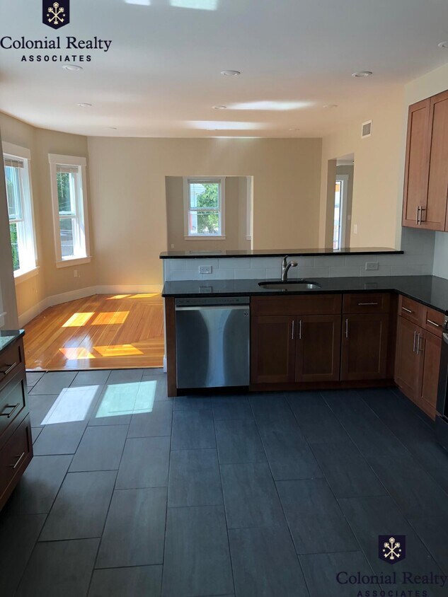
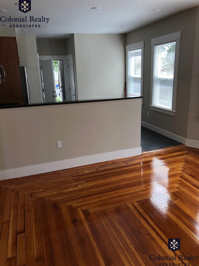
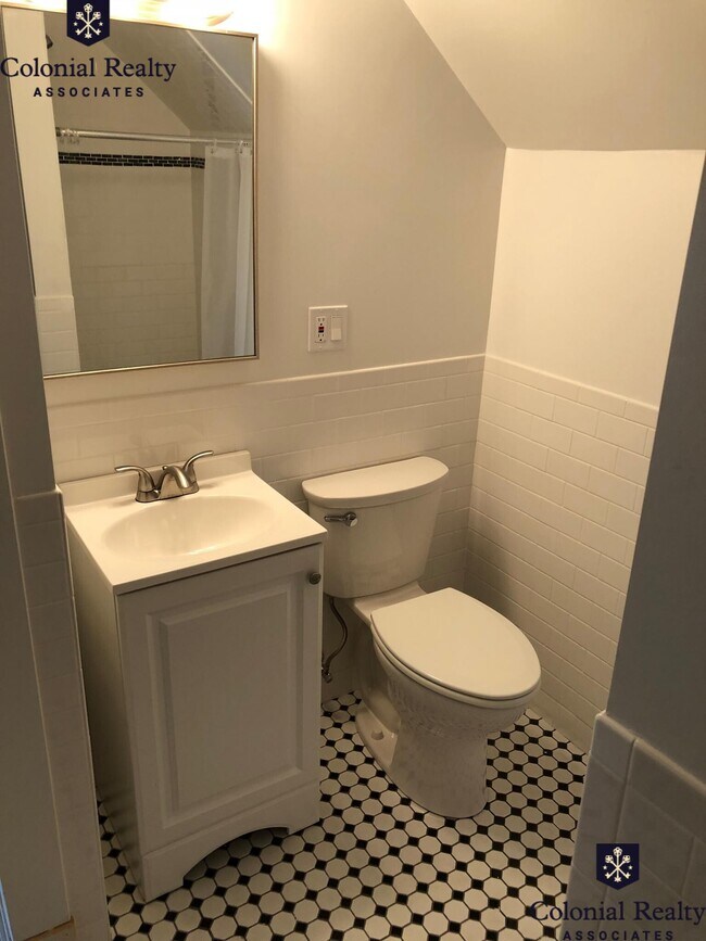
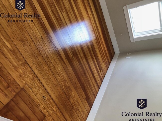
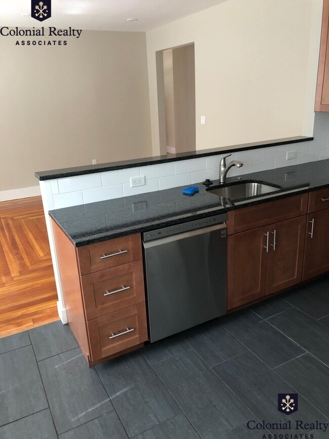
Central Air Ceramic Tiles Completely Renovated Dishwasher Disposal Eat-in Kitchen Granite Counter Tops Hardwood Floors Microwave Modern Kitchen Parking Stainless Steel Appliance(s)
20 Banks St is a condo located in Middlesex County and the 02451 ZIP Code. This area is served by the Waltham School District attendance zone.
20 Banks St,
Waltham,
MA
02451
Bank Square is a quaint, family-friendly neighborhood in Waltham, Massachusetts with a variety of apartments and condos for rent. Just 11 miles west of downtown Boston and just seven miles from Harvard University, Bank Square is near a multitude of wonderful big city amenities. Residents enjoy the walkable downtown, local restaurants, and community parks.
Take a walk along the 18-acre Nipper Maher Park, or enjoy the playground, splash pad, open green space, woodlands, tennis and basketball courts, and baseball field. Take your canoe or kayak out onto the Charles River, or maybe explore Riverwalk Park. You can bike, walk your dog, or jog along the Charles River Greenway with beautiful river views.
Main Street is the best place to find local restaurants such as the Mad Raven, a quaint Irish Pub. Hannaford Supermarket is a massive place to get fresh groceries downtown with nearby banks, convenience stores, and more. Treat yourself or your whole family to a night out at The Chateau.
Learn more about living in Bank SquareBelow are rent ranges for similar nearby apartments
| Beds | Average Size | Lowest | Typical | Premium |
|---|---|---|---|---|
| Studio Studio Studio | 549 Sq Ft | $1,650 | $2,548 | $3,840 |
| 1 Bed 1 Bed 1 Bed | 754-756 Sq Ft | $1,900 | $2,989 | $5,450 |
| 2 Beds 2 Beds 2 Beds | 1267-1269 Sq Ft | $2,500 | $3,641 | $5,115 |
| 3 Beds 3 Beds 3 Beds | 2230 Sq Ft | $2,700 | $4,064 | $6,390 |
| 4 Beds 4 Beds 4 Beds | 3379 Sq Ft | $3,500 | $5,952 | $7,500 |
Education
| Colleges & Universities | Distance | ||
|---|---|---|---|
| Colleges & Universities | Distance | ||
| Drive: | 4 min | 1.4 mi | |
| Drive: | 5 min | 2.4 mi | |
| Drive: | 15 min | 6.3 mi | |
| Drive: | 14 min | 6.7 mi |
20 Banks St Unit 2B is within 4 minutes or 1.4 miles from Brandeis University. It is also near Bentley University and Boston College.
Schools


Public Elementary School
Grades PK-5
396 Students
Nearby
Public Elementary School
Grades K-5
335 Students
Attendance Zone
Public Middle School
Grades 6-8
645 Students
Attendance Zone
Public High School
Grades 9-12
1,784 Students
Attendance Zone
Private Elementary & Middle School
Grades PK-8
517 Students
Nearby
Private Elementary & Middle School
Grades PK-8
115 Students
Nearby
Private Elementary, Middle & High School
Grades K-12
80 Students
Nearby
Private Middle & High School
Grades 6-12
178 Students
Nearby
School data provided by
 The GreatSchools Rating helps parents compare schools within a state based on a variety of school quality indicators and provides a helpful picture of how effectively each school serves all of its students. Ratings are on a scale of 1 (below average) to 10 (above average) and can include test scores, college readiness, academic progress, advanced courses, equity, discipline and attendance data. We also advise parents to visit schools, consider other information on school performance and programs, and consider family needs as part of the school selection process.
View GreatSchools Rating Methodology
Data provided by GreatSchools.org © 2026. All rights reserved.
View GreatSchools Rating Methodology
Data provided by GreatSchools.org © 2026. All rights reserved.
Transportation options available in Waltham include Riverside Station, located 3.4 miles from 20 Banks St Unit 2B. 20 Banks St Unit 2B is near General Edward Lawrence Logan International, located 14.7 miles or 26 minutes away, and Worcester Regional, located 40.2 miles or 57 minutes away.
| Transit / Subway | Distance | ||
|---|---|---|---|
| Transit / Subway | Distance | ||
|
|
Drive: | 8 min | 3.4 mi |
|
|
Drive: | 8 min | 4.0 mi |
|
|
Drive: | 12 min | 5.6 mi |
|
|
Drive: | 10 min | 6.0 mi |
|
|
Drive: | 12 min | 7.6 mi |
| Commuter Rail | Distance | ||
|---|---|---|---|
| Commuter Rail | Distance | ||
| Walk: | 16 min | 0.8 mi | |
|
|
Walk: | 17 min | 0.9 mi |
|
|
Drive: | 3 min | 1.3 mi |
|
|
Drive: | 3 min | 1.9 mi |
|
|
Drive: | 13 min | 7.6 mi |
| Airports | Distance | ||
|---|---|---|---|
| Airports | Distance | ||
|
General Edward Lawrence Logan International
|
Drive: | 26 min | 14.7 mi |
|
Worcester Regional
|
Drive: | 57 min | 40.2 mi |
Walkability Near 20 Banks St Waltham, MA 02451
Getting Around
 What do Walkability, Transit, Drivability, and Bikeability mean?
Walkability measures the walking distance to day-to-day needs.
Transit measures access to public transportation.
Drivability measures congestion, parking availability, and access to major roads.
Bikeability measures the suitability for cycling.
How It Works
What do Walkability, Transit, Drivability, and Bikeability mean?
Walkability measures the walking distance to day-to-day needs.
Transit measures access to public transportation.
Drivability measures congestion, parking availability, and access to major roads.
Bikeability measures the suitability for cycling.
How It Works
Moderately Walkable
Walkability
60
/ 100
Some Public Transit
Transit
40
/ 100
Moderately Drivable
Drivability
70
/ 100
Moderately Bikeable
Bikeability
60
/ 100
Scores provided by
-
Soundscore™
-
/ 100
Traffic
-Airport
-Businesses
-Scores provided by
HowLoud What is a Sound Score Rating? A Sound Score Rating aggregates noise caused by vehicle traffic, airplane traffic and local sources. How It WorksTime and distance from 20 Banks St Unit 2B.
| Shopping Centers | Distance | ||
|---|---|---|---|
| Shopping Centers | Distance | ||
| Walk: | 6 min | 0.3 mi | |
| Walk: | 17 min | 0.9 mi | |
| Drive: | 3 min | 1.2 mi |
20 Banks St Unit 2B has 3 shopping centers within 1.2 miles, which is about a 3-minute drive. The miles and minutes will be for the farthest away property.
| Parks and Recreation | Distance | ||
|---|---|---|---|
| Parks and Recreation | Distance | ||
|
Land's Sake Farm
|
Drive: | 6 min | 3.0 mi |
|
Beaver Brook Reservation
|
Drive: | 6 min | 3.0 mi |
|
Mass Audubon's Habitat Education Center and Wildlife Sanctuary
|
Drive: | 10 min | 4.9 mi |
|
Mass Audubon's Drumlin Farm Wildlife Sanctuary
|
Drive: | 9 min | 5.4 mi |
|
Hemlock Gorge Reservation
|
Drive: | 12 min | 7.4 mi |
20 Banks St Unit 2B has 5 parks within 7.4 miles, including Land's Sake Farm, Beaver Brook Reservation, and Mass Audubon's Habitat Education Center and Wildlife Sanctuary.
| Hospitals | Distance | ||
|---|---|---|---|
| Hospitals | Distance | ||
| Walk: | 12 min | 0.7 mi | |
| Drive: | 6 min | 3.4 mi | |
| Drive: | 8 min | 5.0 mi |
20 Banks St Unit 2B has 3 hospitals within 5.0 miles, the nearest is Walden Behavioral Care which is 0.7 mile away and a 12 minute walk.
| Military Bases | Distance | ||
|---|---|---|---|
| Military Bases | Distance | ||
| Drive: | 15 min | 8.1 mi | |
| Drive: | 19 min | 10.8 mi | |
| Drive: | 48 min | 30.6 mi |
20 Banks St Unit 2B has 3 military bases within 30.6 miles, the nearest is Hanscom Air Force Base which is 8.1 miles away and a 15 minute drive.
You May Also Like
Similar Rentals Nearby


What Are Walk Score®, Transit Score®, and Bike Score® Ratings?
Walk Score® measures the walkability of any address. Transit Score® measures access to public transit. Bike Score® measures the bikeability of any address.
What is a Sound Score Rating?
A Sound Score Rating aggregates noise caused by vehicle traffic, airplane traffic and local sources.

20 Banks St
Waltham, MA 02451