
$4,995
/ Month
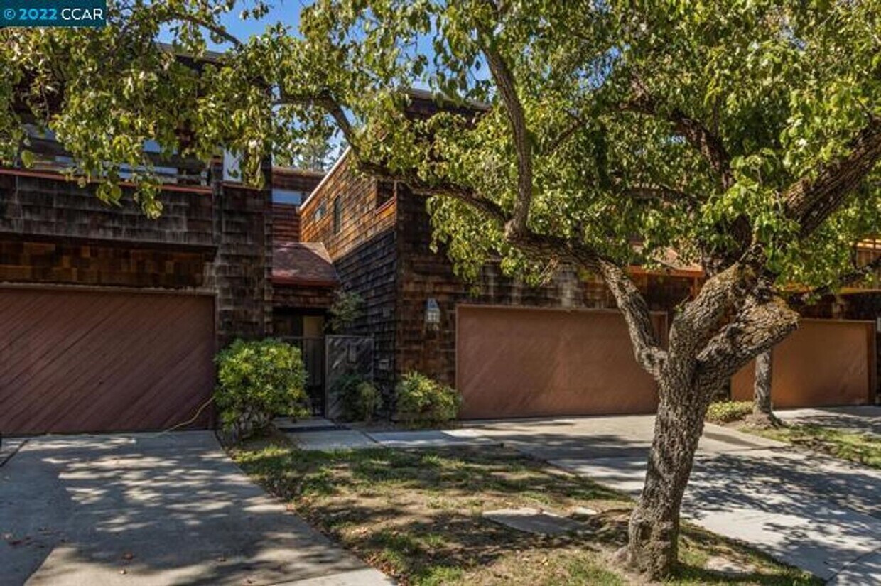
1986 Fair Ridge Ct
Walnut Creek, CA 94597
Today
Favorites
925-899-9405
-
Bedrooms
3
-
Bathrooms
2.5
-
Square Feet
2,134 sq ft
-
Available
Available Sep 10
1986 Fair Ridge Ct

Favorites
About This Home
$4,500 deposit,
Available Sep 10
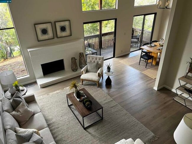
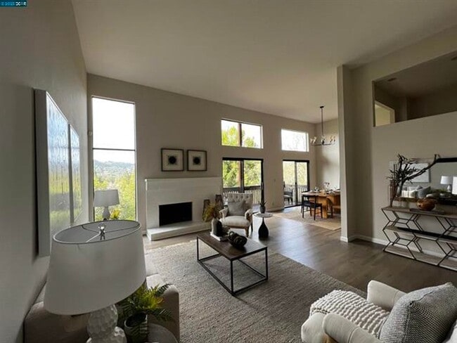
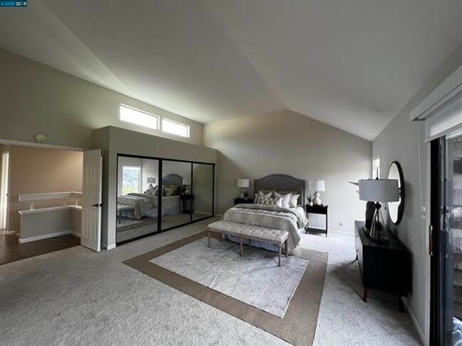
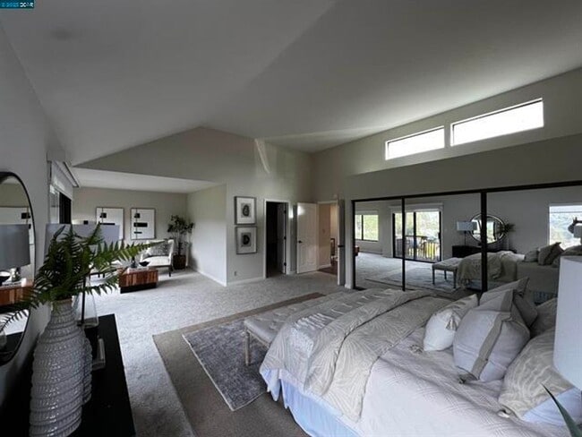
This is an incredible property in the Summit Ridge Community in Walnut Creek. Located in the hills above Acalanes High School, it is conveniently located with easy access to Acalanes High School, Springhill Elementary, Briones Regional Park, Springbook Swim Club, Hwy 24, Interstate 680, Lafayette Bart, Walnut Creek Bart, Pleasant Hill Bart, Downtown Lafayette, Downtown Walnut Creek, Palos Verdes Shopping Center and much much more. The property features: - 3 bedrooms and 2.5 bathrooms with 2,134 SF - hardwood floors - high ceilings - central heat and air - spacious updated kitchen - huge primary bedroom - incredible views of Briones Regional Park - Two-car garage with interior access, built-in cabinetry & sink, plus a 220v EV Charger. - Washer / Dryer in the garage - HOA community with pool, BBQ, clubhouse, and Spa. Small pets considered on approval. Washer, Dryer, Fridge and garage shelving offered without warranty No smoking For more information or to arrange a showing, please call Broker/Property Manager Ed Basaldua (DRE 01178254) at .
Unique Features
- washer and dryer provided without warranty
- HOA
- refrigerator provided without warranty
1986 Fair Ridge Ct is a townhome located in Contra Costa County and the 94597 ZIP Code. This area is served by the Lafayette Elementary attendance zone.
* Price shown is base rent and may not include non-optional fees and utilities. Price, availability, fees, and any applicable rent special are subject to change without notice.
* Square footage definitions vary. Displayed square footage is approximate.
Contact
- Listed by ParkOne Properties, Inc. | ParkOne Properties, Inc.
- Phone Number
- Contact
Location
Get Directions
Amenities
- washer and dryer provided without warranty
- HOA
- refrigerator provided without warranty
Conveniently located near Oakland and San Francisco, Walnut Creek is an East Bay community filled with rugged, wide-open spaces and an abundance of shopping opportunities, making it the ideal city for easy access to big-city amenities and the great outdoors. Walnut Creek is roughly 30 minutes from Oakland by vehicle, but if public transportation is your preference, this suburb also has direct BART service to both Oakland and San Fran!
Walnut Creek is home to numerous bike paths for both recreation and practical transportation—if you enjoy running your errands or getting to work by bike. Upscale apartments near downtown are very walkable, while rentals towards the east end offer residents easy access to nearby nature preserves and the city’s open spaces. Walnut Creek owns more open space per capita than any city in California, giving residents an enormous amount of room to enjoy outdoor activities.
Learn more about living in Walnut Creek
Education
| Colleges & Universities | Distance | ||
|---|---|---|---|
| Colleges & Universities | Distance | ||
| Drive: | 11 min | 5.2 mi | |
| Drive: | 16 min | 6.1 mi | |
| Drive: | 23 min | 13.1 mi | |
| Drive: | 24 min | 13.5 mi |
1986 Fair Ridge Ct is within 11 minutes or 5.2 miles from Diablo Valley, Pleasant Hill. It is also near Saint Marys Coll. of Calif. and UC Berkeley.
Schools


Public Elementary School
Grades K-5
270 Students
Nearby
Public Elementary School
Grades K-5
453 Students
Attendance Zone
Public Middle School
Grades 6-8
1,064 Students
Attendance Zone
Public High School
Grades 9-12
1,259 Students
Attendance Zone
Private Elementary, Middle & High School
Grades PK-12
296 Students
Nearby
School data provided by
 The GreatSchools Rating helps parents compare schools within a state based on a variety of school quality indicators and provides a helpful picture of how effectively each school serves all of its students. Ratings are on a scale of 1 (below average) to 10 (above average) and can include test scores, college readiness, academic progress, advanced courses, equity, discipline and attendance data. We also advise parents to visit schools, consider other information on school performance and programs, and consider family needs as part of the school selection process.
View GreatSchools Rating Methodology
Data provided by GreatSchools.org © 2025. All rights reserved.
View GreatSchools Rating Methodology
Data provided by GreatSchools.org © 2025. All rights reserved.
Transportation options available in Walnut Creek include Lafayette Station, located 2.9 miles from 1986 Fair Ridge Ct. 1986 Fair Ridge Ct is near Metro Oakland International, located 22.9 miles or 33 minutes away, and San Francisco International, located 34.9 miles or 51 minutes away.
| Transit / Subway | Distance | ||
|---|---|---|---|
| Transit / Subway | Distance | ||
|
|
Drive: | 5 min | 2.9 mi |
|
|
Drive: | 7 min | 3.4 mi |
|
|
Drive: | 9 min | 3.8 mi |
|
|
Drive: | 11 min | 7.0 mi |
|
|
Drive: | 11 min | 7.0 mi |
| Commuter Rail | Distance | ||
|---|---|---|---|
| Commuter Rail | Distance | ||
|
|
Drive: | 17 min | 9.3 mi |
|
|
Drive: | 23 min | 14.3 mi |
|
|
Drive: | 22 min | 16.0 mi |
|
|
Drive: | 26 min | 18.0 mi |
| Drive: | 33 min | 23.7 mi |
| Airports | Distance | ||
|---|---|---|---|
| Airports | Distance | ||
|
Metro Oakland International
|
Drive: | 33 min | 22.9 mi |
|
San Francisco International
|
Drive: | 51 min | 34.9 mi |
Time and distance from 1986 Fair Ridge Ct.
| Shopping Centers | Distance | ||
|---|---|---|---|
| Shopping Centers | Distance | ||
| Drive: | 4 min | 1.7 mi | |
| Drive: | 6 min | 2.5 mi | |
| Drive: | 8 min | 3.5 mi |
1986 Fair Ridge Ct has 3 shopping centers within 3.5 miles, which is about a 8-minute drive. The miles and minutes will be for the farthest away property.
| Parks and Recreation | Distance | ||
|---|---|---|---|
| Parks and Recreation | Distance | ||
|
Lindsay Wildlife Museum
|
Drive: | 5 min | 2.3 mi |
|
Larkey Park
|
Drive: | 5 min | 2.5 mi |
|
Butterfly Habitat Gardens
|
Drive: | 8 min | 4.4 mi |
|
Civic Park
|
Drive: | 8 min | 4.4 mi |
|
Briones Regional Park
|
Drive: | 16 min | 7.2 mi |
1986 Fair Ridge Ct has 5 parks within 7.2 miles, including Larkey Park, Lindsay Wildlife Museum, and Butterfly Habitat Gardens.
| Hospitals | Distance | ||
|---|---|---|---|
| Hospitals | Distance | ||
| Drive: | 9 min | 4.1 mi | |
| Drive: | 10 min | 5.2 mi | |
| Drive: | 14 min | 8.0 mi |
1986 Fair Ridge Ct has 3 hospitals within 8.0 miles, the nearest is Kaiser Foundation Hospital - Walnut Creek which is 4.1 miles away and a 9 minute drive.
You May Also Like
Similar Rentals Nearby


 - 329 Williams Way")

What Are Walk Score®, Transit Score®, and Bike Score® Ratings?
Walk Score® measures the walkability of any address. Transit Score® measures access to public transit. Bike Score® measures the bikeability of any address.
What is a Sound Score Rating?
A Sound Score Rating aggregates noise caused by vehicle traffic, airplane traffic and local sources

1986 Fair Ridge Ct
Walnut Creek, CA 94597