

$7,000 / Month
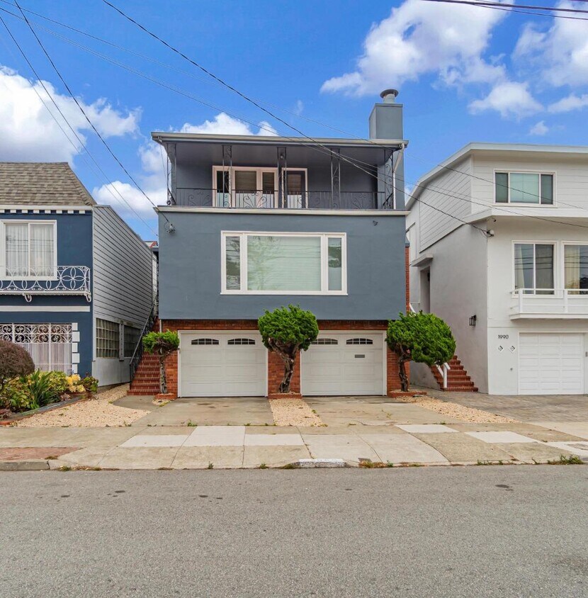
1986 36th Ave
San Francisco, CA 94116
2 Weeks Ago
Favorites
1986 36th Ave

Favorites
Check Back Soon for Upcoming Availability
| Beds | Baths | Average SF |
|---|---|---|
| 3 Bedrooms 3 Bedrooms 3 Br | 3.5 Baths 3.5 Baths 3.5 Ba | 2,337 SF |
Fees and Policies
The fees below are based on community-supplied data and may exclude additional fees and utilities.
About This Property
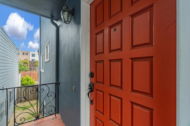
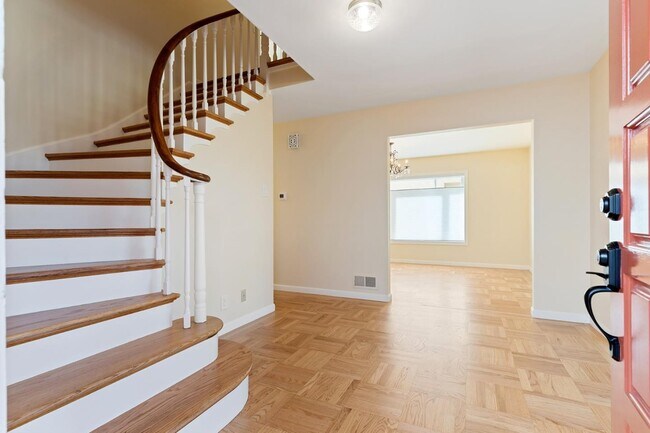
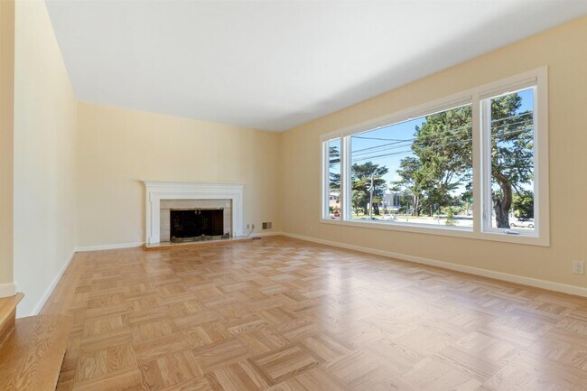
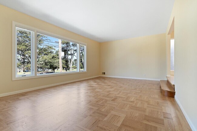
This expansive 3 level home has been well cared & awaiting for new residents. This home boasts 3 spacious beds, 3.5 full baths, 2 bonus rooms & an optimum floorplan ideal for your everyday living & entertaining. The main level consist of the living room, formal dining room, kitchen, laundry room, one bedroom & a full-sized bathroom. Relax in the oversized living room w/ high ceilings, a wood burning fireplace & enjoy views through the large picture window. Enjoy preparing meals in the kitchen w/ S/S appliances & plenty of counter & storage space. The top floor consist of 2 generously sized bedroom suites, both w/ ample closet space & each w/ their own full-sized baths. The ground level consist of a half bath & 2 additional bonus rooms, ideal for additional entertaining space or living area. Short drive to local parks, restaurants, grocery stores, Ocean Beach, Golden Gate Park, Lake Merced and the SF Zoo. Don't miss the local farmers market on 37th Ave. Walk Score 80 (Very Walkable) - Transit Score 57 (Good Transit) - Bike Score 74 (Very Bikeable)
1986 36th Ave is a house located in San Francisco County and the 94116 ZIP Code. This area is served by the San Francisco Unified attendance zone.
House Features
- Fireplace
Location
Get Directions
Central Sunset is a densely populated area about one mile east of the beach and five miles west of the heart of San Francisco. Renters have a large selection of apartments, single-family homes, and condos to choose from. Central Sunset’s residential neighborhoods are paired with parks like Stern Grove Park and McCoppin Square. For in-town shopping and dining, residents head to Taraval Street, Irving Street, and Noriega Street. A variety of eateries serving everything from seafood and barbecue can be found along these roads. This Bay Area suburb is also in proximity to the world-renowned dining, shopping, and entertainment offered by Downtown San Francisco and its neighboring cities.
Learn more about living in Central SunsetBelow are rent ranges for similar nearby apartments
Amenities
- Fireplace
Education
| Colleges & Universities | Distance | ||
|---|---|---|---|
| Colleges & Universities | Distance | ||
| Drive: | 7 min | 2.7 mi | |
| Drive: | 9 min | 3.1 mi | |
| Drive: | 12 min | 3.9 mi | |
| Drive: | 10 min | 4.4 mi |
1986 36th Ave is within 7 minutes or 2.7 miles from San Francisco State University. It is also near UC San Francisco, Parnassus and City College of San Francisco.
Schools


Public Elementary School
Grades K-5
394 Students
Nearby
Public Elementary School
Grades K-5
437 Students
Attendance Zone
Public Middle School
Grades 6-8
1,192 Students
Attendance Zone
Public High School
Grades 9-12
2,632 Students
Attendance Zone
Public High School
Grades 9-12
1,997 Students
Attendance Zone
Private Elementary & Middle School
Grades PK-8
131 Students
Nearby
Private Elementary & Middle School
Grades PK-8
437 Students
Nearby
Private Middle & High School
Grades 6-12
1,537 Students
Nearby
School data provided by
 The GreatSchools Rating helps parents compare schools within a state based on a variety of school quality indicators and provides a helpful picture of how effectively each school serves all of its students. Ratings are on a scale of 1 (below average) to 10 (above average) and can include test scores, college readiness, academic progress, advanced courses, equity, discipline and attendance data. We also advise parents to visit schools, consider other information on school performance and programs, and consider family needs as part of the school selection process.
View GreatSchools Rating Methodology
Data provided by GreatSchools.org © 2025. All rights reserved.
View GreatSchools Rating Methodology
Data provided by GreatSchools.org © 2025. All rights reserved.
Transportation options available in San Francisco include Taraval St & Sunset Blvd, located 0.6 mile from 1986 36th Ave. 1986 36th Ave is near San Francisco International, located 14.3 miles or 24 minutes away, and Metro Oakland International, located 26.1 miles or 45 minutes away.
| Transit / Subway | Distance | ||
|---|---|---|---|
| Transit / Subway | Distance | ||
| Walk: | 11 min | 0.6 mi | |
| Walk: | 14 min | 0.8 mi | |
| Walk: | 15 min | 0.8 mi | |
| Walk: | 16 min | 0.9 mi | |
| Walk: | 17 min | 0.9 mi |
| Commuter Rail | Distance | ||
|---|---|---|---|
| Commuter Rail | Distance | ||
| Drive: | 17 min | 7.2 mi | |
| Drive: | 18 min | 7.2 mi | |
| Drive: | 17 min | 7.8 mi | |
| Drive: | 17 min | 8.8 mi | |
| Drive: | 17 min | 8.8 mi |
| Airports | Distance | ||
|---|---|---|---|
| Airports | Distance | ||
|
San Francisco International
|
Drive: | 24 min | 14.3 mi |
|
Metro Oakland International
|
Drive: | 45 min | 26.1 mi |
Time and distance from 1986 36th Ave.
| Shopping Centers | Distance | ||
|---|---|---|---|
| Shopping Centers | Distance | ||
| Drive: | 4 min | 1.5 mi | |
| Drive: | 7 min | 2.6 mi | |
| Drive: | 9 min | 3.2 mi |
1986 36th Ave has 3 shopping centers within 3.2 miles, which is about a 9-minute drive. The miles and minutes will be for the farthest away property.
| Parks and Recreation | Distance | ||
|---|---|---|---|
| Parks and Recreation | Distance | ||
|
San Francisco Zoo
|
Drive: | 5 min | 1.8 mi |
|
Golden Gate Park
|
Drive: | 7 min | 2.4 mi |
|
San Francisco Botanical Garden
|
Drive: | 6 min | 2.5 mi |
|
Japanese Tea Garden
|
Drive: | 9 min | 3.3 mi |
|
Steinhart Aquarium
|
Drive: | 10 min | 3.6 mi |
1986 36th Ave has 5 parks within 3.6 miles, including San Francisco Zoo, Golden Gate Park, and San Francisco Botanical Garden.
| Hospitals | Distance | ||
|---|---|---|---|
| Hospitals | Distance | ||
| Drive: | 7 min | 2.6 mi | |
| Drive: | 8 min | 2.9 mi | |
| Drive: | 8 min | 3.0 mi |
1986 36th Ave has 3 hospitals within 3.0 miles, the nearest is Laguna Honda Hospital & Rehabilitation Center which is 2.6 miles away and a 7 minute drive.
| Military Bases | Distance | ||
|---|---|---|---|
| Military Bases | Distance | ||
| Drive: | 9 min | 3.1 mi | |
| Drive: | 11 min | 3.6 mi |
1986 36th Ave is 3.1 miles from West Fort Miley, and is convenient to other military bases, including East Fort Miley.
You May Also Like
Similar Rentals Nearby


What Are Walk Score®, Transit Score®, and Bike Score® Ratings?
Walk Score® measures the walkability of any address. Transit Score® measures access to public transit. Bike Score® measures the bikeability of any address.
What is a Sound Score Rating?
A Sound Score Rating aggregates noise caused by vehicle traffic, airplane traffic and local sources
1986 36th Ave
San Francisco, CA 94116