

$2,295
/ Month
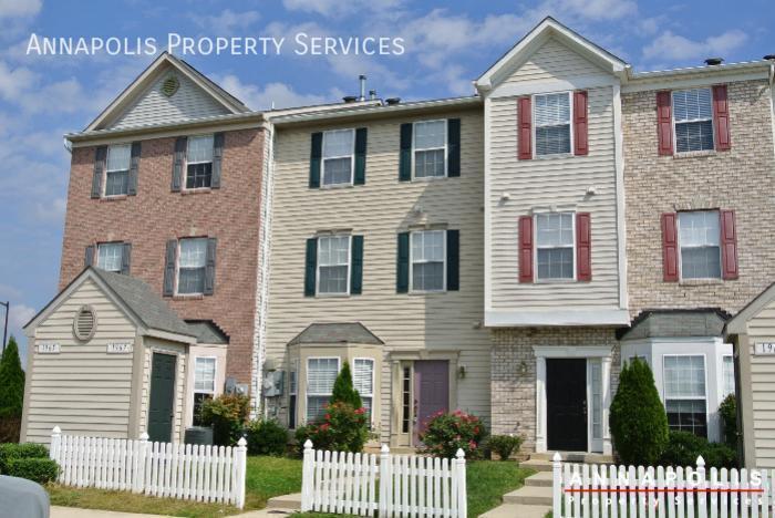
1967 Buckwheat Ct
Odenton, MD 21113
2 Weeks Ago
|
Edit
Favorites
1967 Buckwheat Ct

Favorites
Check Back Soon for Upcoming Availability
| Beds | Baths | Average SF |
|---|---|---|
| 3 Bedrooms 3 Bedrooms 3 Br | 3 Baths 3 Baths 3 Ba | 1,572 SF |
Fees and Policies
The fees listed below are community-provided and may exclude utilities or add-ons. All payments are made directly to the property and are non-refundable unless otherwise specified.
- Dogs Allowed
-
Fees not specified
- Cats Allowed
-
Fees not specified
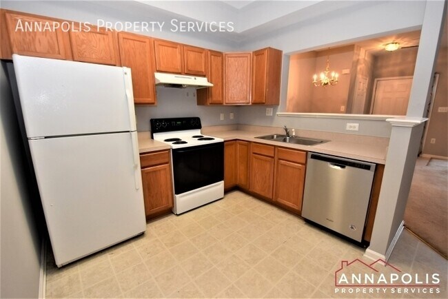
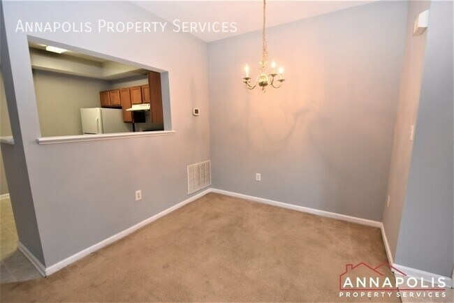
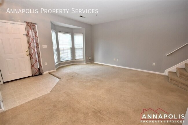
About This Property
---- PROGRAMAR UNA VISITA EN LÍNEA EN: ---- Amplia casa adosada de tres niveles en la comunidad de Seven Oaks en Odenton. 3 dormitorios, 2,5 baños con una gran suite principal en el tercer piso. Sala de estar y área de cocina de planta abierta con gran ventanal. Las instalaciones comunitarias incluyen dos piscinas, canchas de tenis, gimnasios y canchas de voleibol y baloncesto. Comunidad de siete robles Información sobre mascotas Gato: Sí Perro: Sí
1967 Buckwheat Ct is a townhome located in Anne Arundel County and the 21113 ZIP Code. This area is served by the Anne Arundel County Public Schools attendance zone.
Townhome Features
Aire acondicionado
Lavavajillas
Microondas
Nevera
- Aire acondicionado
- Lavavajillas
- Zona de eliminación de desechos
- Microondas
- Nevera
- Gimnasio
1967 Buckwheat Ct,
Odenton,
MD
21113
Odenton sits at a geographic crossroads in Anne Arundel County, positioned roughly equidistant between Baltimore, Washington, D.C., and Annapolis. That location is not a coincidence — it has shaped the community's identity as one of Maryland's fastest-growing areas, driven largely by the presence of Fort George G. Meade, which hosts the NSA headquarters and U.S. Cyber Command. The result is a community with steady demand, a broad range of employers, and a population that leans toward government, defense, and technology sectors.
Neighborhoods like Piney Orchard and Seven Oaks each carry a distinct character. Piney Orchard offers wooded trails, a village center, and preserved green space along the Little Patuxent River, while Seven Oaks sits closer to Fort Meade with easy base access. The Odenton Town Center continues to develop around the MARC Penn Line station, making transit-oriented living a genuine option for those commuting to D.C. or Baltimore.
Learn more about living in Odenton
Amenities
- Aire acondicionado
- Lavavajillas
- Zona de eliminación de desechos
- Microondas
- Nevera
- Gimnasio
Education
| Colleges & Universities | Distance | ||
|---|---|---|---|
| Colleges & Universities | Distance | ||
| Drive: | 25 min | 14.5 mi | |
| Drive: | 25 min | 15.0 mi | |
| Drive: | 28 min | 15.1 mi | |
| Drive: | 28 min | 16.1 mi |
1967 Buckwheat Ct is within 25 minutes or 14.5 miles from UMBC. It is also near CCBC Cantonsville and Anne Arundel Community College.
Schools


Public Elementary School
Grades PK-5
508 Students
Attendance Zone
Public Middle School
Grades 6-8
878 Students
Attendance Zone
Public High School
Grades 9-12
2,330 Students
Attendance Zone
Private Elementary, Middle & High School
Grades PK-12
279 Students
Nearby
Private Elementary, Middle & High School
Grades K-12
7 Students
Nearby
School data provided by
 The GreatSchools Rating helps parents compare schools within a state based on a variety of school quality indicators and provides a helpful picture of how effectively each school serves all of its students. Ratings are on a scale of 1 (below average) to 10 (above average) and can include test scores, college readiness, academic progress, advanced courses, equity, discipline and attendance data. We also advise parents to visit schools, consider other information on school performance and programs, and consider family needs as part of the school selection process.
View GreatSchools Rating Methodology
Data provided by GreatSchools.org © 2026. All rights reserved.
View GreatSchools Rating Methodology
Data provided by GreatSchools.org © 2026. All rights reserved.
Transportation options available in Odenton include Dorsey, located 8.0 miles from 1967 Buckwheat Ct. 1967 Buckwheat Ct is near Baltimore/Washington International Thurgood Marshall, located 8.9 miles or 18 minutes away, and Ronald Reagan Washington Ntl, located 31.5 miles or 50 minutes away.
| Transit / Subway | Distance | ||
|---|---|---|---|
| Transit / Subway | Distance | ||
|
|
Drive: | 16 min | 8.0 mi |
|
|
Drive: | 17 min | 8.8 mi |
|
|
Drive: | 19 min | 9.1 mi |
|
|
Drive: | 17 min | 9.4 mi |
|
|
Drive: | 18 min | 9.8 mi |
| Commuter Rail | Distance | ||
|---|---|---|---|
| Commuter Rail | Distance | ||
|
|
Drive: | 6 min | 2.3 mi |
|
|
Drive: | 12 min | 5.8 mi |
|
|
Drive: | 14 min | 8.0 mi |
| Drive: | 16 min | 8.0 mi | |
| Drive: | 16 min | 8.1 mi |
| Airports | Distance | ||
|---|---|---|---|
| Airports | Distance | ||
|
Baltimore/Washington International Thurgood Marshall
|
Drive: | 18 min | 8.9 mi |
|
Ronald Reagan Washington Ntl
|
Drive: | 50 min | 31.5 mi |
Walkability Near 1967 Buckwheat Ct Odenton, MD 21113
Getting Around
 What do Walkability, Transit, Drivability, and Bikeability mean?
Walkability measures the walking distance to day-to-day needs.
Transit measures access to public transportation.
Drivability measures congestion, parking availability, and access to major roads.
Bikeability measures the suitability for cycling.
How It Works
What do Walkability, Transit, Drivability, and Bikeability mean?
Walkability measures the walking distance to day-to-day needs.
Transit measures access to public transportation.
Drivability measures congestion, parking availability, and access to major roads.
Bikeability measures the suitability for cycling.
How It Works
Fairly Walkable
Walkability
40
/ 100
Minimal Public Transit
Transit
10
/ 100
Moderately Drivable
Drivability
70
/ 100
Somewhat Bikeable
Bikeability
30
/ 100
Scores provided by
-
Soundscore™
-
/ 100
Traffic
-Airport
-Businesses
-Scores provided by
HowLoud What is a Sound Score Rating? A Sound Score Rating aggregates noise caused by vehicle traffic, airplane traffic and local sources. How It WorksTime and distance from 1967 Buckwheat Ct.
| Shopping Centers | Distance | ||
|---|---|---|---|
| Shopping Centers | Distance | ||
| Walk: | 17 min | 0.9 mi | |
| Drive: | 3 min | 1.1 mi | |
| Drive: | 5 min | 2.1 mi |
1967 Buckwheat Ct has 3 shopping centers within 2.1 miles, which is about a 5-minute drive. The miles and minutes will be for the farthest away property.
| Parks and Recreation | Distance | ||
|---|---|---|---|
| Parks and Recreation | Distance | ||
|
Patuxent Research Refuge - North Tract
|
Drive: | 12 min | 5.8 mi |
|
Kinder Farm Park
|
Drive: | 23 min | 11.4 mi |
|
Patuxent Research Refuge - South Tract
|
Drive: | 26 min | 13.9 mi |
1967 Buckwheat Ct has 3 parks within 13.9 miles, including Patuxent Research Refuge - North Tract, Kinder Farm Park, and Patuxent Research Refuge - South Tract.
| Hospitals | Distance | ||
|---|---|---|---|
| Hospitals | Distance | ||
| Drive: | 17 min | 8.7 mi | |
| Drive: | 22 min | 11.7 mi |
1967 Buckwheat Ct is 8.7 miles from University of Maryland Baltimore Washington Medical Center, and is convenient to other hospitals, including Laurel Regional Medical Center.
| Military Bases | Distance | ||
|---|---|---|---|
| Military Bases | Distance | ||
| Drive: | 6 min | 2.6 mi |
1967 Buckwheat Ct is 2.6 miles and a 6 minute drive from Fort George Meade.
You May Also Like
-
Villages at Morgan Metro
8251 Ridgefield Blvd
Landover, MD 20785
$2,315 - $3,970
3-4 Br 16.4 mi
-
Parkside Gardens Apartments and Townhouses
5305 Moravia Rd
Baltimore, MD 21206
$1,471 - $1,474
3 Br 17.4 mi
-
Banner Lane
44 Banner Ln
Washington, DC 20001
$4,585 - $4,620 Total Monthly Price
3 Br 12 Month Lease 21.3 mi
Similar Rentals Nearby


What Are Walk Score®, Transit Score®, and Bike Score® Ratings?
Walk Score® measures the walkability of any address. Transit Score® measures access to public transit. Bike Score® measures the bikeability of any address.
What is a Sound Score Rating?
A Sound Score Rating aggregates noise caused by vehicle traffic, airplane traffic and local sources.
1967 Buckwheat Ct
Odenton, MD 21113