

$5,300 / Month
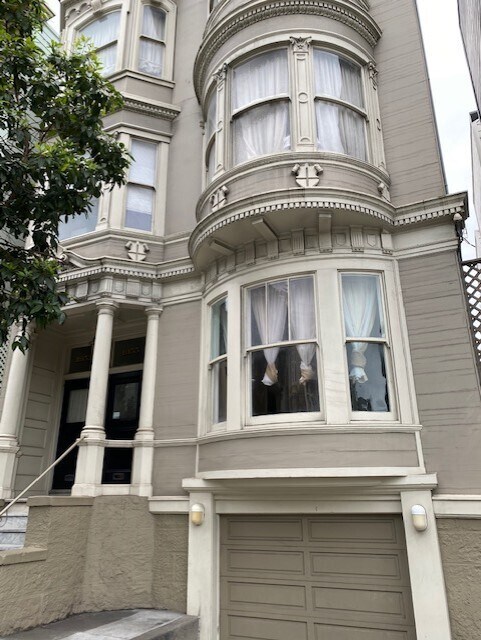
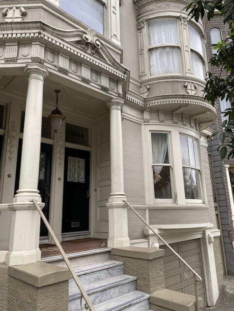
1957 Pine St Unit 1957
San Francisco, CA 94109
2 Weeks Ago
Favorites
1957 Pine St Unit 1957

Favorites
Check Back Soon for Upcoming Availability
| Beds | Baths | Average SF |
|---|---|---|
| 3 Bedrooms 3 Bedrooms 3 Br | 2.5 Baths 2.5 Baths 2.5 Ba | 2,050 SF |
Fees and Policies
The fees below are based on community-supplied data and may exclude additional fees and utilities.
About This Property
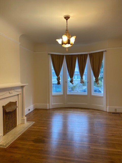
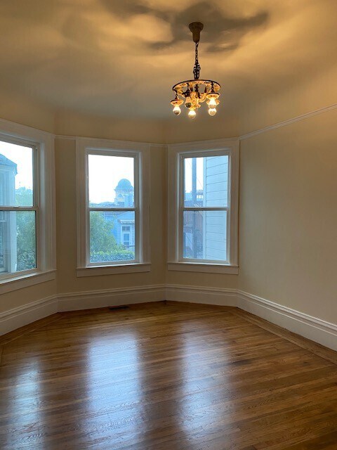
Large condominium located at Lower Pacific Heights. This newly painted three bedroom, two and a half bath condo unit features newly refinished hardwood floors throughout, a spacious living room with a decorative fireplace, large kitchen area with tiled floors, white cabinets, kitchen island, jacuzzi tub, and washroom. Two bedrooms have each a decorative fireplace and a separate laundry area with a washer and dryer. Shared well-maintained backyard. The monthly rent is $5,300.00. Minimum of one year lease. A security deposit of $7,950.00 plus first month's rent required upon signing. Tenant pays all utilities. Must have good credit (650+) and monthly income is equivalent to 3 times the rent. No smoking and no pets allowed. Convenient location! TRANSPORTATION: Walk score: 99 (walkers paradise) Transit score: 79 (excellent transit) Nearest bus stops: Sacramento St & Octavia St - 5 min walk Sacramento St & Laguna St - 5 min walk BART: Powell St Station - 1.1 miles Civic Center Station - 1 mile Airport: SFO - 19 min drive US 101 Freeway: 0.6 miles, 3 min drive Groceries, restaurants: Japan town Lots of restaurant options Mollie Stones Trader Joe’s Lucky’s Parks: Lafayette Park Alamo Square Park Historical Landmarks: Lombard Street Painted Ladies Hospitals: California Pacific Medical Center - Van Ness Campus 0.6 miles - Pacific Heights Campus 0.4 miles UCSF Medical Center at Mt. Zion - 0.9 miles Kaiser Permanente Geary St - 1.1 miles
1957 Pine St is a condo located in San Francisco County and the 94109 ZIP Code.
Condo Features
- Washer/Dryer
- Smoke Free
- Dishwasher
Location
Get Directions
Lower Pacific Heights is a vibrant San Francisco neighborhood situated between Pacific Heights, Japantown, the Fillmore District, and Laurel Heights. Formerly known as Upper Fillmore, Lower Pacific Heights offers residents a wide variety of apartments, condos, and houses available for rent, many of which boast scenic views due to the neighborhood’s hilly environment.
Lower Pacific Heights is regarded for its walkable layout, with many rentals situated within easy walking distance of the diverse restaurants, shops, coffeehouses, and bars that line Fillmore Street, the community’s main commercial thoroughfare. The neighborhood’s central locale is a major part of its allure, providing quick access to Union Square, the University of San Francisco, the Financial District, several prominent medical centers, tech employers, landmarks, and more.
Learn more about living in Lower Pacific HeightsBelow are rent ranges for similar nearby apartments
Amenities
- Washer/Dryer
- Smoke Free
- Dishwasher
Education
| Colleges & Universities | Distance | ||
|---|---|---|---|
| Colleges & Universities | Distance | ||
| Walk: | 16 min | 0.8 mi | |
| Drive: | 4 min | 1.4 mi | |
| Drive: | 6 min | 2.0 mi | |
| Drive: | 6 min | 2.1 mi |
1957 Pine St Unit 1957 is within 16 minutes or 0.8 mile from UC San Francisco, Mount Zion. It is also near Academy of Art University and Golden Gate Univ., San Fran..
Transportation options available in San Francisco include Van Ness And California, located 0.4 mile from 1957 Pine St Unit 1957. 1957 Pine St Unit 1957 is near San Francisco International, located 14.9 miles or 25 minutes away, and Metro Oakland International, located 20.5 miles or 33 minutes away.
| Transit / Subway | Distance | ||
|---|---|---|---|
| Transit / Subway | Distance | ||
|
|
Walk: | 8 min | 0.4 mi |
|
|
Walk: | 11 min | 0.6 mi |
|
|
Walk: | 12 min | 0.7 mi |
|
|
Walk: | 16 min | 0.8 mi |
|
|
Walk: | 17 min | 0.9 mi |
| Commuter Rail | Distance | ||
|---|---|---|---|
| Commuter Rail | Distance | ||
| Drive: | 7 min | 2.6 mi | |
| Drive: | 8 min | 2.6 mi | |
| Drive: | 9 min | 4.1 mi | |
| Drive: | 9 min | 4.1 mi | |
| Drive: | 13 min | 7.1 mi |
| Airports | Distance | ||
|---|---|---|---|
| Airports | Distance | ||
|
San Francisco International
|
Drive: | 25 min | 14.9 mi |
|
Metro Oakland International
|
Drive: | 33 min | 20.5 mi |
Time and distance from 1957 Pine St Unit 1957.
| Shopping Centers | Distance | ||
|---|---|---|---|
| Shopping Centers | Distance | ||
| Walk: | 8 min | 0.4 mi | |
| Walk: | 8 min | 0.4 mi | |
| Drive: | 5 min | 1.6 mi |
1957 Pine St Unit 1957 has 3 shopping centers within 1.6 miles, which is about a 5-minute walk. The miles and minutes will be for the farthest away property.
| Parks and Recreation | Distance | ||
|---|---|---|---|
| Parks and Recreation | Distance | ||
|
Children's Creativity Museum
|
Drive: | 6 min | 1.9 mi |
|
San Francisco Maritime National Historical Park
|
Drive: | 6 min | 2.0 mi |
|
Buena Vista Park
|
Drive: | 7 min | 2.2 mi |
|
Exploratorium
|
Drive: | 6 min | 2.3 mi |
|
Aquarium of The Bay
|
Drive: | 8 min | 2.5 mi |
1957 Pine St Unit 1957 has 5 parks within 2.5 miles, including San Francisco Maritime National Historical Park, Children's Creativity Museum, and Exploratorium.
| Hospitals | Distance | ||
|---|---|---|---|
| Hospitals | Distance | ||
| Walk: | 11 min | 0.6 mi | |
| Walk: | 12 min | 0.6 mi | |
| Drive: | 4 min | 1.5 mi |
1957 Pine St Unit 1957 has 3 hospitals within 1.5 miles, the nearest is California Pacific Medical Center - Van Ness Campus which is 0.6 mile away and a 11 minute walk.
| Military Bases | Distance | ||
|---|---|---|---|
| Military Bases | Distance | ||
| Drive: | 13 min | 4.4 mi | |
| Drive: | 14 min | 4.8 mi | |
| Drive: | 16 min | 6.6 mi |
1957 Pine St Unit 1957 has 3 military bases within 6.6 miles, the nearest is East Fort Miley which is 4.4 miles away and a 13 minute drive.
You May Also Like
Similar Rentals Nearby
-
-

-
 $5,6954 Beds, 1.5 Baths, 1,293 sq ftApartment for Rent
 -
 $7,0005 Beds, 2.5 Baths, 1,400 sq ftRoom for Rent
 -

-

-

-
 $7,4504 Beds, 2.5 Baths, 2,800 sq ftApartment for Rent
 -

-

What Are Walk Score®, Transit Score®, and Bike Score® Ratings?
Walk Score® measures the walkability of any address. Transit Score® measures access to public transit. Bike Score® measures the bikeability of any address.
What is a Sound Score Rating?
A Sound Score Rating aggregates noise caused by vehicle traffic, airplane traffic and local sources

1957 Pine St
San Francisco, CA 94109