$3,575
/ Month
1952 Pomar Way
Walnut Creek, CA 94598
Today
|
Edit
Favorites
510-391-3854
-
Bedrooms
2
-
Bathrooms
2.5
-
Square Feet
1,308 sq ft
-
Available
Available Jan 11, 2026
Highlights
- Patio
- Smoke Free
1952 Pomar Way

Favorites
About This Home
12 Month Lease,
$3,575 deposit,
Available Jan 11, 2026
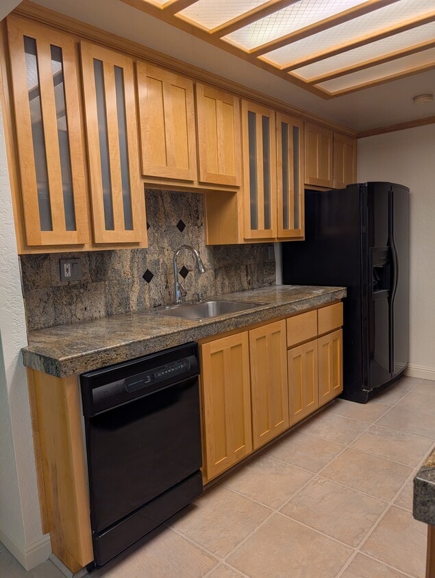
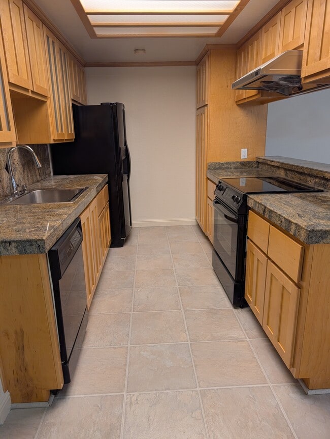
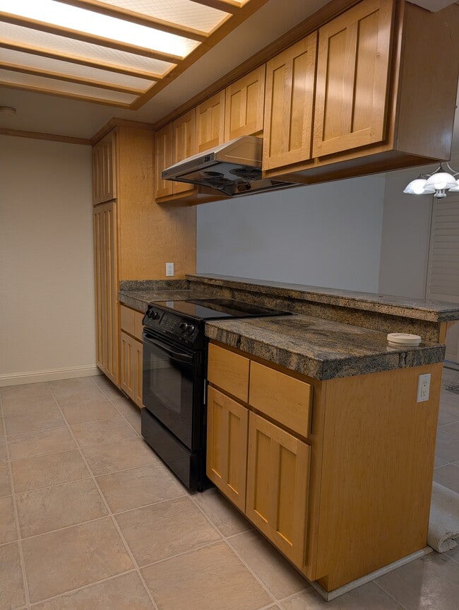
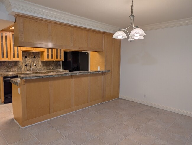
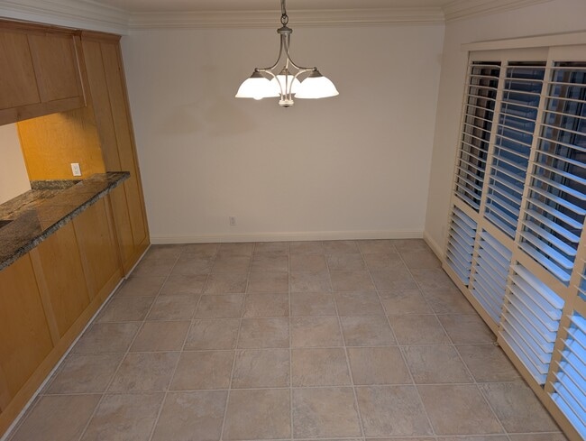
This well-maintained townhouse features an updated kitchen with custom maple cabinetry, granite countertops, a dishwasher, stove, large refrigerator, and a spacious pantry cabinet offering ample storage. The home is equipped with double-pane windows and patio doors throughout, providing excellent insulation and a quiet interior. Both the front and rear sliding patio doors are fitted with custom interior wood shutters, adding a clean, modern aesthetic. The living room includes newly installed recessed lighting with a dimmer, allowing for flexible lighting control. Fresh carpeting has been installed throughout the home, and the interior has been freshly painted, resulting in an immaculate overall condition. A full-size washer and dryer are conveniently located inside the unit. The private front and back patios both include landscape for gardening opportunities. The property offers approximately 1,308 square feet of living space and includes a one-car garage with a large storage cabinet and additional shelving. Ample guest and street parking are also available. Located in the quiet Sunset Park neighborhood at the corner of Treat Boulevard and Bancroft Road, the home is within easy walking distance of the Countrywood Shopping Center, including Safeway. Nearby amenities include the Iron Horse Trail for walking and biking, Heather Farm Park, Pleasant Hill BART station, and convenient access to downtown Walnut Creek and Pleasant Hill, both approximately 10 minutes away. This is a smoke-free and pet-free property.
1952 Pomar Way is a townhome located in Contra Costa County and the 94598 ZIP Code.
* Price shown is base rent. Excludes user-selected optional fees and variable or usage-based fees and required charges due at or prior to move-in or at move-out. Price, availability, fees, and any applicable rent special are subject to change without notice.
* Square footage definitions vary. Displayed square footage is approximate.
Townhome Features
Washer/Dryer
Dishwasher
Granite Countertops
Refrigerator
- Washer/Dryer
- Heating
- Ceiling Fans
- Smoke Free
- Storage Space
- Tub/Shower
- Dishwasher
- Granite Countertops
- Pantry
- Kitchen
- Refrigerator
- Double Pane Windows
- Walking/Biking Trails
- Patio
Fees and Policies
The fees below are based on community-supplied data and may exclude additional fees and utilities.
- Parking
-
Garage--
Details
Utilities Included
-
Gas
-
Water
-
Trash Removal
-
Sewer
Contact
- Phone Number
- Contact
Location
Get Directions
Nestled in the East Bay region of the San Francisco Bay Area, Walnut Creek combines suburban comfort with city amenities. The city encompasses 1,800 acres of open space, featuring Shell Ridge and Lime Ridge trails for hiking and outdoor recreation. Downtown Walnut Creek features Broadway Plaza shopping district, while the Lesher Center for the Arts hosts performances and cultural events. The rental market shows a 1.7% annual increase, with one-bedroom units averaging $2,476 and two-bedroom homes typically renting for $2,953. Notable areas include Parkmead, Walnut Heights, and the Northgate district.
Established in 1849 along what early settlers called "Nuts Creek," Walnut Creek has grown into a community of over 70,000 residents. The Mediterranean climate makes it ideal for exploring outdoor spaces like Heather Farm Park and the Ruth Bancroft Garden.
Learn more about living in Walnut Creek
Education
| Colleges & Universities | Distance | ||
|---|---|---|---|
| Colleges & Universities | Distance | ||
| Drive: | 11 min | 4.2 mi | |
| Drive: | 21 min | 9.4 mi | |
| Drive: | 26 min | 14.8 mi | |
| Drive: | 28 min | 16.6 mi |
1952 Pomar Way is within 11 minutes or 4.2 miles from Diablo Valley, Pleasant Hill. It is also near Saint Marys Coll. of Calif. and Los Medanos College, Pittsburg.
Transportation options available in Walnut Creek include Pleasant Hill Station, located 1.0 mile from 1952 Pomar Way. 1952 Pomar Way is near Metro Oakland International, located 26.4 miles or 38 minutes away, and San Francisco International, located 38.3 miles or 56 minutes away.
| Transit / Subway | Distance | ||
|---|---|---|---|
| Transit / Subway | Distance | ||
|
|
Walk: | 19 min | 1.0 mi |
|
|
Drive: | 7 min | 3.1 mi |
|
|
Drive: | 10 min | 4.5 mi |
|
|
Drive: | 10 min | 6.4 mi |
|
|
Drive: | 11 min | 7.2 mi |
| Commuter Rail | Distance | ||
|---|---|---|---|
| Commuter Rail | Distance | ||
|
|
Drive: | 16 min | 11.0 mi |
|
|
Drive: | 28 min | 17.8 mi |
|
|
Drive: | 27 min | 19.5 mi |
|
|
Drive: | 27 min | 19.8 mi |
|
|
Drive: | 31 min | 21.4 mi |
| Airports | Distance | ||
|---|---|---|---|
| Airports | Distance | ||
|
Metro Oakland International
|
Drive: | 38 min | 26.4 mi |
|
San Francisco International
|
Drive: | 56 min | 38.3 mi |
Time and distance from 1952 Pomar Way.
| Shopping Centers | Distance | ||
|---|---|---|---|
| Shopping Centers | Distance | ||
| Walk: | 7 min | 0.4 mi | |
| Walk: | 16 min | 0.8 mi | |
| Drive: | 3 min | 1.2 mi |
1952 Pomar Way has 3 shopping centers within 1.2 miles, which is about a 3-minute drive. The miles and minutes will be for the farthest away property.
| Parks and Recreation | Distance | ||
|---|---|---|---|
| Parks and Recreation | Distance | ||
|
The Ruth Bancroft Garden
|
Walk: | 10 min | 0.6 mi |
|
Heather Farm Park
|
Drive: | 3 min | 1.3 mi |
|
Gardens at Heather Farm
|
Drive: | 3 min | 1.4 mi |
|
Larkey Park
|
Drive: | 5 min | 2.1 mi |
|
Lindsay Wildlife Museum
|
Drive: | 5 min | 2.1 mi |
1952 Pomar Way has 5 parks within 2.1 miles, including The Ruth Bancroft Garden, Gardens at Heather Farm, and Heather Farm Park.
| Hospitals | Distance | ||
|---|---|---|---|
| Hospitals | Distance | ||
| Drive: | 3 min | 1.3 mi | |
| Drive: | 7 min | 3.5 mi | |
| Drive: | 10 min | 6.1 mi |
1952 Pomar Way has 3 hospitals within 6.1 miles, the nearest is John Muir Medical Center - Walnut Creek Campus which is 1.3 miles away and a 3 minute drive.
Amenities
- Washer/Dryer
- Heating
- Ceiling Fans
- Smoke Free
- Storage Space
- Tub/Shower
- Dishwasher
- Granite Countertops
- Pantry
- Kitchen
- Refrigerator
- Double Pane Windows
- Patio
- Walking/Biking Trails
1952 Pomar Way Photos
What Are Walk Score®, Transit Score®, and Bike Score® Ratings?
Walk Score® measures the walkability of any address. Transit Score® measures access to public transit. Bike Score® measures the bikeability of any address.
What is a Sound Score Rating?
A Sound Score Rating aggregates noise caused by vehicle traffic, airplane traffic and local sources

1952 Pomar Way
Walnut Creek, CA 94598