
$2,795
/ Month
195 Langdon Farm Cir
Odenton, MD 21113
Today
Favorites
443-636-7537
-
Bedrooms
3
-
Bathrooms
3
-
Square Feet
--
-
Available
Available Now
Highlight
- Basement
195 Langdon Farm Cir

Favorites
About This Home
Available Now
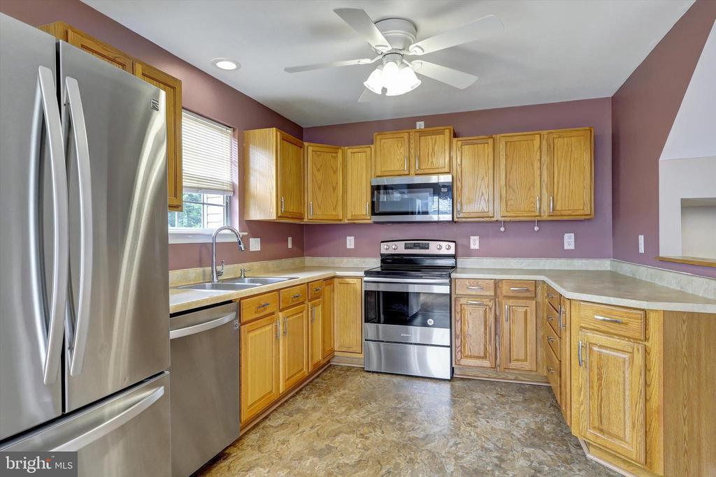
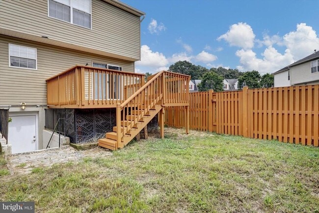
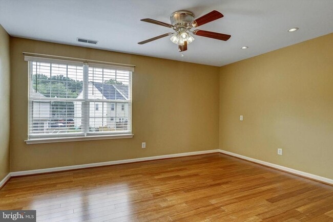
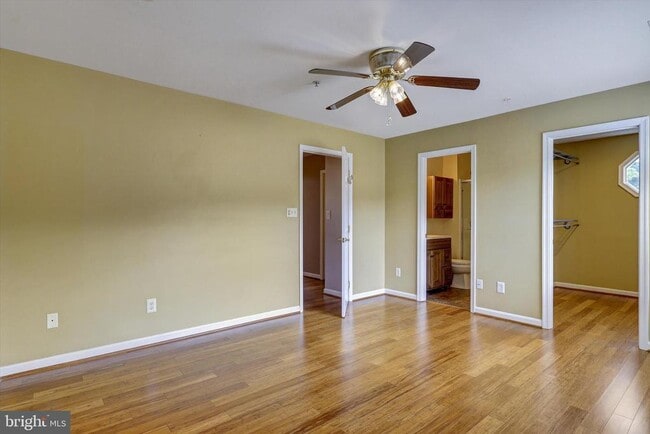
Looking for a home that prioritizes Child privacy and security? Look no further! This beautiful end-unit townhouse comes with a completely fenced backyard which seamlessly converts into a private playground where your children can have fun and enjoy their favorite games. At the main floor, the open plan living and dining space allows superb ambience and plenty of natural light. The generous use of hardwood flooring in every space except the bathrooms and lower level sets this home apart from many in its criteria. Every room comes with an elegant ceiling plan. The curb appeal is a remarkable feature of this house. it's frontage warmly welcomes your guests. It also has two assigned parking spaces . It comes with a fully finished walk-out lower level. Great outdoor living space includes a spacious and freshly painted rear deck and fully fenced back yard. The finished attic incorporates pull down stairs , providing additional storage. Plenty of other storage cupboards on each floor, including a generous pantry. The walk-in closet at the Premier bedroom is incredibly generous for a townhouse. The Community club house and swimming pool is only five minutes walk away, and provides added facilities in an already family-friendly community. This home certainly offers you just the location and lifestyle you are looking for.
195 Langdon Farm Cir is a townhome located in Anne Arundel County and the 21113 ZIP Code. This area is served by the Anne Arundel County Public Schools attendance zone.
* Price shown is base rent. Excludes user-selected optional fees and variable or usage-based fees and required charges due at or prior to move-in or at move-out. Price, availability, fees, and any applicable rent special are subject to change without notice.
* Square footage definitions vary. Displayed square footage is approximate.
Townhome Features
- Basement
Contact
- Listed by Olufemi A Ifaturoti | Samson Properties
- Phone Number
- Contact
-
Source
 Bright MLS, Inc.
Copyright © 2025 Bright MLS, Inc.
Location
Get Directions
Amenities
- Basement
Situated in Anne Arundel County, Odenton is centrally located between Annapolis, Washington D.C., and Baltimore. The city is continuously growing in population, largely due to its proximity to Fort George G. Meade military base and the developing Piney Orchard neighborhood.
In Odenton, you’ll discover a lot of great shopping centers like Waugh Chapel Towne Centre. Hikers will enjoy the plethora of trails that reside within the community, including Little Patuxent River Trail, Wild Turkey Way, and Merganser Pond Trail, among others. Midland Park is a large green space just minutes from Bowie State University. This Baltimore suburb contains highly rated public schools, plus access to Interstate 97 and Odenton Station.
Learn more about living in Odenton
Education
| Colleges & Universities | Distance | ||
|---|---|---|---|
| Colleges & Universities | Distance | ||
| Drive: | 23 min | 13.7 mi | |
| Drive: | 24 min | 14.2 mi | |
| Drive: | 27 min | 16.0 mi | |
| Drive: | 29 min | 16.9 mi |
195 Langdon Farm Cir is within 23 minutes or 13.7 miles from UMBC. It is also near CCBC Cantonsville and Anne Arundel Community College.
Schools


Public Elementary School
Grades PK-5
508 Students
Attendance Zone
Public Middle School
Grades 6-8
878 Students
Attendance Zone
Public High School
Grades 9-12
2,330 Students
Attendance Zone
Private Elementary, Middle & High School
Grades PK-12
181 Students
Nearby
Private Elementary, Middle & High School
Grades 2-12
7 Students
Nearby
School data provided by
 The GreatSchools Rating helps parents compare schools within a state based on a variety of school quality indicators and provides a helpful picture of how effectively each school serves all of its students. Ratings are on a scale of 1 (below average) to 10 (above average) and can include test scores, college readiness, academic progress, advanced courses, equity, discipline and attendance data. We also advise parents to visit schools, consider other information on school performance and programs, and consider family needs as part of the school selection process.
View GreatSchools Rating Methodology
Data provided by GreatSchools.org © 2025. All rights reserved.
View GreatSchools Rating Methodology
Data provided by GreatSchools.org © 2025. All rights reserved.
Transportation options available in Odenton include Dorsey, located 7.2 miles from 195 Langdon Farm Cir. 195 Langdon Farm Cir is near Baltimore/Washington International Thurgood Marshall, located 8.7 miles or 17 minutes away, and Ronald Reagan Washington Ntl, located 31.4 miles or 50 minutes away.
| Transit / Subway | Distance | ||
|---|---|---|---|
| Transit / Subway | Distance | ||
|
|
Drive: | 14 min | 7.2 mi |
|
|
Drive: | 17 min | 8.6 mi |
|
|
Drive: | 18 min | 9.0 mi |
|
|
Drive: | 16 min | 9.2 mi |
|
|
Drive: | 17 min | 9.6 mi |
| Commuter Rail | Distance | ||
|---|---|---|---|
| Commuter Rail | Distance | ||
|
|
Drive: | 7 min | 3.1 mi |
|
|
Drive: | 11 min | 5.0 mi |
| Drive: | 14 min | 7.3 mi | |
| Drive: | 14 min | 7.3 mi | |
|
|
Drive: | 13 min | 7.9 mi |
| Airports | Distance | ||
|---|---|---|---|
| Airports | Distance | ||
|
Baltimore/Washington International Thurgood Marshall
|
Drive: | 17 min | 8.7 mi |
|
Ronald Reagan Washington Ntl
|
Drive: | 50 min | 31.4 mi |
Time and distance from 195 Langdon Farm Cir.
| Shopping Centers | Distance | ||
|---|---|---|---|
| Shopping Centers | Distance | ||
| Walk: | 20 min | 1.0 mi | |
| Walk: | 20 min | 1.1 mi | |
| Drive: | 6 min | 2.9 mi |
195 Langdon Farm Cir has 3 shopping centers within 2.9 miles, which is about a 6-minute walk. The miles and minutes will be for the farthest away property.
| Parks and Recreation | Distance | ||
|---|---|---|---|
| Parks and Recreation | Distance | ||
|
Patuxent Research Refuge - North Tract
|
Drive: | 12 min | 5.7 mi |
|
Kinder Farm Park
|
Drive: | 24 min | 13.2 mi |
|
Patuxent Research Refuge - South Tract
|
Drive: | 26 min | 13.9 mi |
195 Langdon Farm Cir has 3 parks within 13.9 miles, including Patuxent Research Refuge - North Tract, Kinder Farm Park, and Patuxent Research Refuge - South Tract.
| Hospitals | Distance | ||
|---|---|---|---|
| Hospitals | Distance | ||
| Drive: | 16 min | 8.5 mi | |
| Drive: | 22 min | 11.6 mi |
195 Langdon Farm Cir is 8.5 miles from University of Maryland Baltimore Washington Medical Center, and is convenient to other hospitals, including Laurel Regional Medical Center.
| Military Bases | Distance | ||
|---|---|---|---|
| Military Bases | Distance | ||
| Drive: | 5 min | 1.8 mi |
195 Langdon Farm Cir is 1.8 miles and a 5 minute drive from Fort George Meade.
You May Also Like
-
The Townhomes at Diamond Ridge
2531 Sarrington Cir
Baltimore, MD 21244
$1,635 - $3,279
3 Br 15.9 mi
-
Villages at Morgan Metro
8251 Ridgefield Blvd
Landover, MD 20785
$2,025 - $3,085
3-4 Br 16.3 mi
-
Parkside Gardens Apartments and Townhouses
5305 Moravia Rd
Baltimore, MD 21206
$1,406 - $1,471
3 Br 17.6 mi
Similar Rentals Nearby


What Are Walk Score®, Transit Score®, and Bike Score® Ratings?
Walk Score® measures the walkability of any address. Transit Score® measures access to public transit. Bike Score® measures the bikeability of any address.
What is a Sound Score Rating?
A Sound Score Rating aggregates noise caused by vehicle traffic, airplane traffic and local sources

195 Langdon Farm Cir
Odenton, MD 21113