
$4,700
/ Month
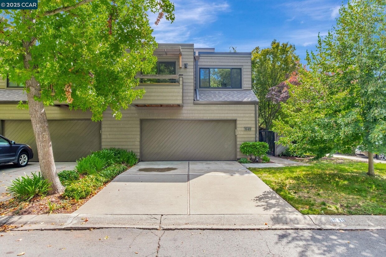
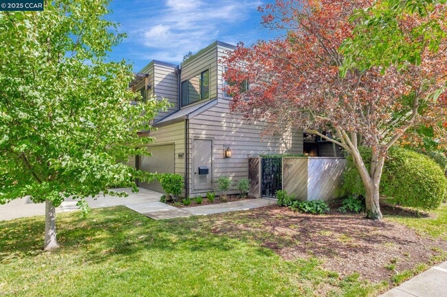
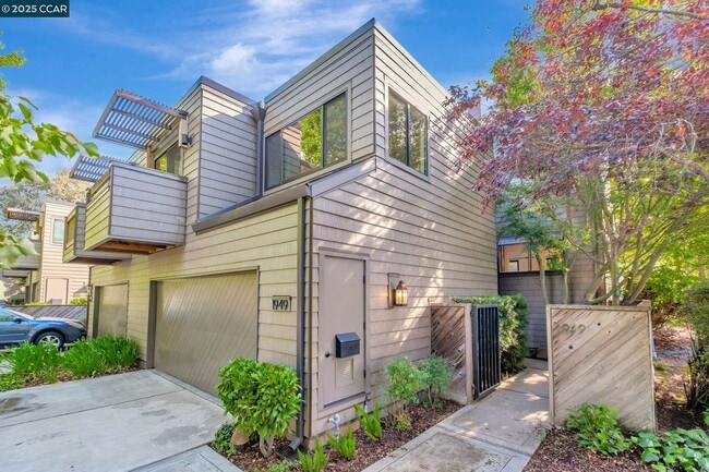
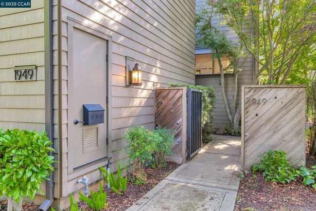
1949 Highridge Ct
Walnut Creek, CA 94597
Today
Favorites
925-323-3193
-
Bedrooms
3
-
Bathrooms
2.5
-
Square Feet
1,798 sq ft
-
Available
Available Now
Highlights
- In Ground Pool
- View of Hills
- Clubhouse
- Contemporary Architecture
- Engineered Wood Flooring
- Community Pool
1949 Highridge Ct

Favorites
About This Home
Available Now
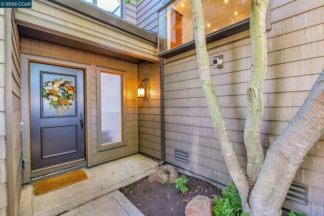
End unit with stunning views of the hill and trees. Features include a top-floor primary suite with vaulted ceilings,two bedrooms and full bath on the second floor,skylight over stairs and entry,and an updated kitchen open to dining and living areas with fireplace. Landscaped ground-level patio. Community amenities: pool,clubhouse,greenbelt,and trail access. Located in the Lafayette School District,near Palos Verdes Shopping Center,and minutes to downtown Walnut Creek and Lafayette. Includes Washer/Dryer and Refrigerator. Apply with RentSpree
1949 Highridge Ct is a townhome located in Contra Costa County and the 94597 ZIP Code. This area is served by the Lafayette Elementary attendance zone.
* Price shown is base rent. Excludes user-selected optional fees and variable or usage-based fees and required charges due at or prior to move-in or at move-out. Price, availability, fees, and any applicable rent special are subject to change without notice.
* Square footage definitions vary. Displayed square footage is approximate.
Home Details
Home Type
Townhome
Year Built
Built in 1978
Bedrooms and Bathrooms
2.5 Bathrooms
3 Bedrooms
Flooring
Engineered Wood
Tile
Carpet
Home Design
Contemporary Architecture
Flat Roof Shape
Tri-Level Property
Interior Spaces
Living Room with Fireplace
Kitchen
Gas Range
Dishwasher
Laundry
Dryer
Laundry in Garage
Washer
Listing and Financial Details
Assessor Parcel Number 1753120789
Lot Details
1,500 Sq Ft Lot
Parking
2 Car Attached Garage
Pool
In Ground Pool
Utilities
Cooling Available
Forced Air Heating System
Views
Views of Hills
Community Details
Amenities
Clubhouse
Overview
$895 Monthly HOA Fees
Summit Ridge HOA
Summit Ridge Subdivision
Association fees include exterior maintenance, hazard insurance
Recreation
Community Pool
Contact
- Listed by Lisa Lombardi | Coldwell Banker
- Phone Number
- Contact
-
Source
 Contra Costa Association of REALTORS®
Copyright © 2025 Bay East, CCAR, bridgeMLS. Based on information from Bay East and Contra Costa Association of REALTORS® and bridgeMLS. All data, including all measurements and calculations of area, is obtained from various sources and has not been, and will not be, verified by broker or MLS. All information should be independently reviewed and verified for accuracy. If a floor plan is included, the floor plan is for illustrative purposes only, and the actual dimensions and layout of the home may differ from the floor plan. Buyer is urged to make a detailed inspection of the property, and if any aspect of a floor plan is critical to the buyer's decision to purchase, buyer must conduct their own measurements and inspection. Properties may or may not be listed by the office/agent presenting the information.
Location
Get Directions
Conveniently located near Oakland and San Francisco, Walnut Creek is an East Bay community filled with rugged, wide-open spaces and an abundance of shopping opportunities, making it the ideal city for easy access to big-city amenities and the great outdoors. Walnut Creek is roughly 30 minutes from Oakland by vehicle, but if public transportation is your preference, this suburb also has direct BART service to both Oakland and San Fran!
Walnut Creek is home to numerous bike paths for both recreation and practical transportation—if you enjoy running your errands or getting to work by bike. Upscale apartments near downtown are very walkable, while rentals towards the east end offer residents easy access to nearby nature preserves and the city’s open spaces. Walnut Creek owns more open space per capita than any city in California, giving residents an enormous amount of room to enjoy outdoor activities.
Learn more about living in Walnut Creek
Education
| Colleges & Universities | Distance | ||
|---|---|---|---|
| Colleges & Universities | Distance | ||
| Drive: | 10 min | 5.1 mi | |
| Drive: | 15 min | 6.0 mi | |
| Drive: | 23 min | 13.0 mi | |
| Drive: | 24 min | 13.4 mi |
1949 Highridge Ct is within 10 minutes or 5.1 miles from Diablo Valley, Pleasant Hill. It is also near Saint Marys Coll. of Calif. and UC Berkeley.
Schools


Public Elementary School
Grades K-5
453 Students
Attendance Zone
Public Elementary School
Grades K-5
270 Students
Nearby
Public Middle School
Grades 6-8
1,064 Students
Attendance Zone
Public High School
Grades 9-12
1,259 Students
Attendance Zone
Private Elementary, Middle & High School
Grades PK-12
296 Students
Nearby
School data provided by
 The GreatSchools Rating helps parents compare schools within a state based on a variety of school quality indicators and provides a helpful picture of how effectively each school serves all of its students. Ratings are on a scale of 1 (below average) to 10 (above average) and can include test scores, college readiness, academic progress, advanced courses, equity, discipline and attendance data. We also advise parents to visit schools, consider other information on school performance and programs, and consider family needs as part of the school selection process.
View GreatSchools Rating Methodology
Data provided by GreatSchools.org © 2025. All rights reserved.
View GreatSchools Rating Methodology
Data provided by GreatSchools.org © 2025. All rights reserved.
Transportation options available in Walnut Creek include Lafayette Station, located 2.8 miles from 1949 Highridge Ct. 1949 Highridge Ct is near Metro Oakland International, located 22.8 miles or 32 minutes away, and San Francisco International, located 34.8 miles or 51 minutes away.
| Transit / Subway | Distance | ||
|---|---|---|---|
| Transit / Subway | Distance | ||
|
|
Drive: | 5 min | 2.8 mi |
|
|
Drive: | 7 min | 3.3 mi |
|
|
Drive: | 8 min | 3.8 mi |
|
|
Drive: | 10 min | 6.9 mi |
|
|
Drive: | 10 min | 6.9 mi |
| Commuter Rail | Distance | ||
|---|---|---|---|
| Commuter Rail | Distance | ||
|
|
Drive: | 17 min | 9.2 mi |
|
|
Drive: | 23 min | 14.2 mi |
|
|
Drive: | 22 min | 16.0 mi |
|
|
Drive: | 26 min | 17.9 mi |
| Drive: | 33 min | 23.6 mi |
| Airports | Distance | ||
|---|---|---|---|
| Airports | Distance | ||
|
Metro Oakland International
|
Drive: | 32 min | 22.8 mi |
|
San Francisco International
|
Drive: | 51 min | 34.8 mi |
Time and distance from 1949 Highridge Ct.
| Shopping Centers | Distance | ||
|---|---|---|---|
| Shopping Centers | Distance | ||
| Drive: | 3 min | 1.6 mi | |
| Drive: | 5 min | 2.4 mi | |
| Drive: | 7 min | 3.4 mi |
1949 Highridge Ct has 3 shopping centers within 3.4 miles, which is about a 7-minute drive. The miles and minutes will be for the farthest away property.
| Parks and Recreation | Distance | ||
|---|---|---|---|
| Parks and Recreation | Distance | ||
|
Lindsay Wildlife Museum
|
Drive: | 5 min | 2.2 mi |
|
Larkey Park
|
Drive: | 5 min | 2.4 mi |
|
Butterfly Habitat Gardens
|
Drive: | 8 min | 4.3 mi |
|
Civic Park
|
Drive: | 8 min | 4.3 mi |
|
Contra Costa Canal Regional Trail
|
Drive: | 9 min | 4.8 mi |
1949 Highridge Ct has 5 parks within 4.8 miles, including Larkey Park, Lindsay Wildlife Museum, and Butterfly Habitat Gardens.
| Hospitals | Distance | ||
|---|---|---|---|
| Hospitals | Distance | ||
| Drive: | 8 min | 4.0 mi | |
| Drive: | 9 min | 5.1 mi | |
| Drive: | 13 min | 7.9 mi |
1949 Highridge Ct has 3 hospitals within 7.9 miles, the nearest is Kaiser Foundation Hospital - Walnut Creek which is 4.0 miles away and a 8 minute drive.
You May Also Like
Similar Rentals Nearby


What Are Walk Score®, Transit Score®, and Bike Score® Ratings?
Walk Score® measures the walkability of any address. Transit Score® measures access to public transit. Bike Score® measures the bikeability of any address.
What is a Sound Score Rating?
A Sound Score Rating aggregates noise caused by vehicle traffic, airplane traffic and local sources

1949 Highridge Ct
Walnut Creek, CA 94597