

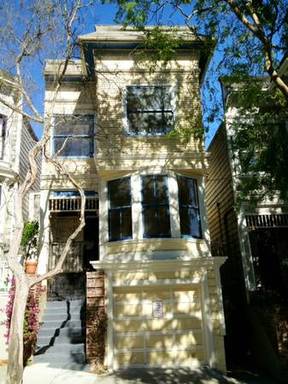
1944 Buchanan St
San Francisco, CA 94115
Favorites
1944 Buchanan St

Favorites
Check Back Soon for Upcoming Availability
| Beds | Baths | Average SF |
|---|---|---|
| 1 Bedroom 1 Bedroom 1 Br | 1 Bath 1 Bath 1 Ba | 800 SF |
About This Property
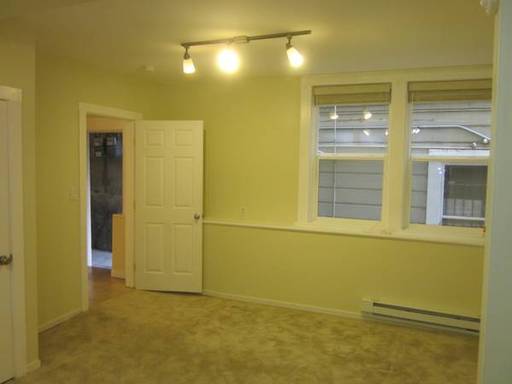
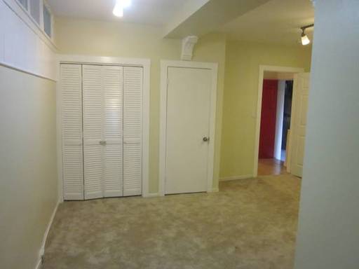
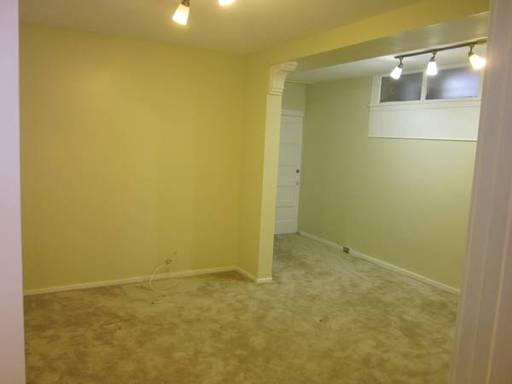
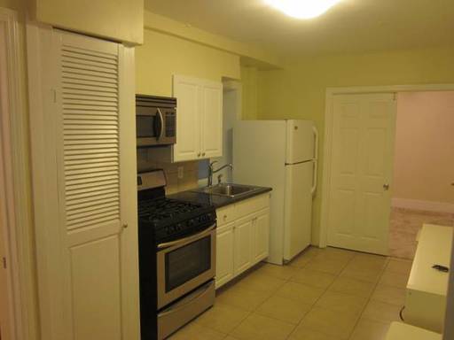
FEATURES - Coveted Pacific Heights Location - Period Edwardian Building - 1 bed+ 1 office - 1 Renovated Bathroom - Brand New Renovated Kitchen - Period Edwardian Details and Moldings - New Floors - In-Unit Washer/Dryer - Parking available on request LOCATION Steps from FILLMORE St, Buchanan Street is a full floor Edwardian flat in a period Edwardian three unit building in the heart of Pacific Heights. This is the quintessential San Francisco apartment located on a quiet, tree-lined street steps to Fillmore Street shops and restaurants, local parks, and transportation. The apartment has been recently renovated (interior is brand new) and is available for immediate occupancy. Features include or one bedroom and one office , renovated bathroom, brand new renovated kitchen with stainless (gas) appliances and in unit washer/dryer. There is a small deck off the kitchen. Nick Korniczky Cell: 415.828.3810 BRE# 01945238
1944 Buchanan St is a house located in San Francisco County and the 94115 ZIP Code.
Location
Get Directions
Lower Pacific Heights is a vibrant San Francisco neighborhood situated between Pacific Heights, Japantown, the Fillmore District, and Laurel Heights. Formerly known as Upper Fillmore, Lower Pacific Heights offers residents a wide variety of apartments, condos, and houses available for rent, many of which boast scenic views due to the neighborhood’s hilly environment.
Lower Pacific Heights is regarded for its walkable layout, with many rentals situated within easy walking distance of the diverse restaurants, shops, coffeehouses, and bars that line Fillmore Street, the community’s main commercial thoroughfare. The neighborhood’s central locale is a major part of its allure, providing quick access to Union Square, the University of San Francisco, the Financial District, several prominent medical centers, tech employers, landmarks, and more.
Learn more about living in Lower Pacific HeightsBelow are rent ranges for similar nearby apartments
Education
| Colleges & Universities | Distance | ||
|---|---|---|---|
| Colleges & Universities | Distance | ||
| Walk: | 12 min | 0.6 mi | |
| Drive: | 4 min | 1.3 mi | |
| Drive: | 5 min | 1.8 mi | |
| Drive: | 6 min | 2.0 mi |
1944 Buchanan St is within 12 minutes or 0.6 mile from UC San Francisco, Mount Zion. It is also near Academy of Art University and University of San Francisco.
Transportation options available in San Francisco include Van Ness And California, located 0.6 mile from 1944 Buchanan St. 1944 Buchanan St is near San Francisco International, located 14.7 miles or 24 minutes away, and Metro Oakland International, located 20.5 miles or 33 minutes away.
| Transit / Subway | Distance | ||
|---|---|---|---|
| Transit / Subway | Distance | ||
|
|
Walk: | 11 min | 0.6 mi |
|
|
Walk: | 14 min | 0.7 mi |
|
|
Walk: | 15 min | 0.8 mi |
|
|
Walk: | 18 min | 1.0 mi |
|
|
Walk: | 20 min | 1.0 mi |
| Commuter Rail | Distance | ||
|---|---|---|---|
| Commuter Rail | Distance | ||
| Drive: | 7 min | 2.5 mi | |
| Drive: | 7 min | 2.6 mi | |
| Drive: | 9 min | 4.0 mi | |
| Drive: | 9 min | 4.1 mi | |
| Drive: | 13 min | 6.9 mi |
| Airports | Distance | ||
|---|---|---|---|
| Airports | Distance | ||
|
San Francisco International
|
Drive: | 24 min | 14.7 mi |
|
Metro Oakland International
|
Drive: | 33 min | 20.5 mi |
Time and distance from 1944 Buchanan St.
| Shopping Centers | Distance | ||
|---|---|---|---|
| Shopping Centers | Distance | ||
| Walk: | 4 min | 0.2 mi | |
| Walk: | 10 min | 0.5 mi | |
| Drive: | 5 min | 1.5 mi |
1944 Buchanan St has 3 shopping centers within 1.5 miles, which is about a 5-minute walk. The miles and minutes will be for the farthest away property.
| Parks and Recreation | Distance | ||
|---|---|---|---|
| Parks and Recreation | Distance | ||
|
Children's Creativity Museum
|
Drive: | 6 min | 1.9 mi |
|
Buena Vista Park
|
Drive: | 6 min | 2.0 mi |
|
San Francisco Maritime National Historical Park
|
Drive: | 5 min | 2.0 mi |
|
Exploratorium
|
Drive: | 5 min | 2.2 mi |
|
Randall Museum
|
Drive: | 7 min | 2.5 mi |
1944 Buchanan St has 5 parks within 2.5 miles, including San Francisco Maritime National Historical Park, Children's Creativity Museum, and Exploratorium.
| Hospitals | Distance | ||
|---|---|---|---|
| Hospitals | Distance | ||
| Walk: | 13 min | 0.7 mi | |
| Walk: | 15 min | 0.8 mi | |
| Drive: | 3 min | 1.3 mi |
1944 Buchanan St has 3 hospitals within 1.3 miles, the nearest is California Pacific Medical Center - Van Ness Campus which is 0.7 mile away and a 13 minute walk.
| Military Bases | Distance | ||
|---|---|---|---|
| Military Bases | Distance | ||
| Drive: | 12 min | 4.2 mi | |
| Drive: | 13 min | 4.6 mi | |
| Drive: | 15 min | 6.6 mi |
1944 Buchanan St has 3 military bases within 6.6 miles, the nearest is East Fort Miley which is 4.2 miles away and a 12 minute drive.
You May Also Like
Similar Rentals Nearby


What Are Walk Score®, Transit Score®, and Bike Score® Ratings?
Walk Score® measures the walkability of any address. Transit Score® measures access to public transit. Bike Score® measures the bikeability of any address.
What is a Sound Score Rating?
A Sound Score Rating aggregates noise caused by vehicle traffic, airplane traffic and local sources
1944 Buchanan St
San Francisco, CA 94115