

$2,400
/ Month
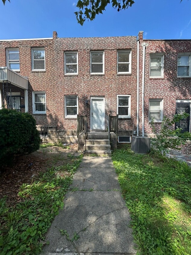
1939 W Chew Ave
Philadelphia, PA 19141
Today
Favorites
267-641-4122
-
Bedrooms
4
-
Bathrooms
2.5
-
Square Feet
1,454 sq ft
-
Available
Available Now
1939 W Chew Ave

Favorites
About This Home
$2,400 deposit,
Available Now
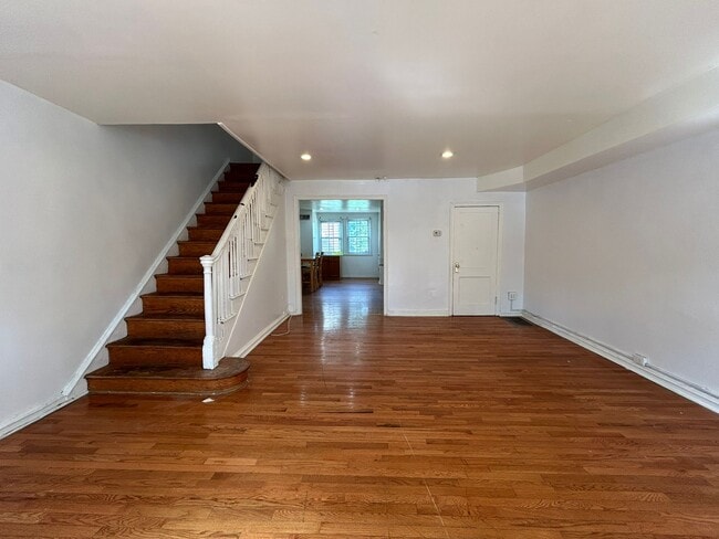
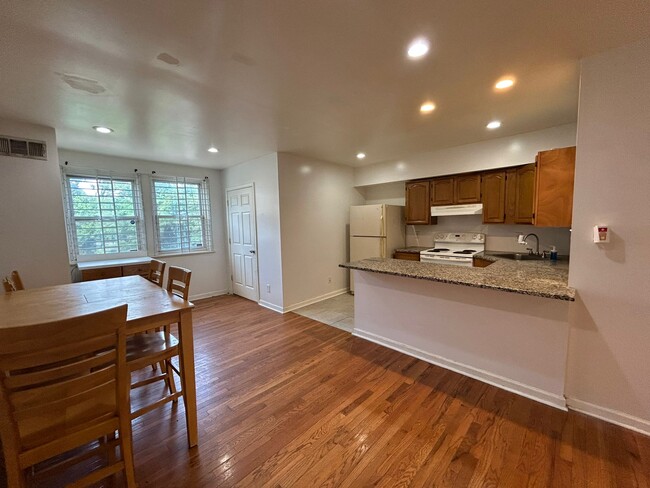
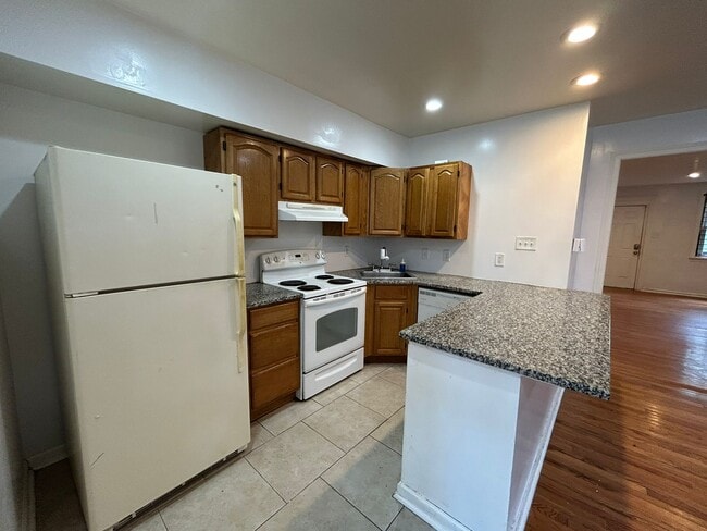
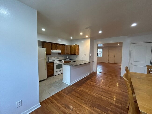
Now available for rent: a well-maintained 4-bedroom, 2.5-bathroom home with a versatile den, located at 1939 Chew Avenue in Philadelphia. This property features hardwood flooring throughout, creating a cohesive and polished look. The main level features a spacious living area and a dining area, which is adjacent to the functional kitchen space. Also, on this level, there is a half bath and a washer/dryer setup for your convenience. Upstairs, you'll find three spacious bedrooms and one full bathroom. At the basement level, there's an additional bedroom and full bathroom, plus a versatile den that can be utilized for work, hobbies, or a theater room. As a bonus, enjoy the comfort of central air conditioning and forced heat for year-round temperature control. As for location, 1939 Chew Avenue is conveniently near La Salle University, the Broad Street Line, Fresh Grocer, restaurants, and more! Schedule your tour soon to make this rental unit your next home!
1939 W Chew Ave is a house located in Philadelphia County and the 19141 ZIP Code.
* Price shown is base rent. Excludes user-selected optional fees and variable or usage-based fees and required charges due at or prior to move-in or at move-out. Price, availability, fees, and any applicable rent special are subject to change without notice.
* Square footage definitions vary. Displayed square footage is approximate.
House Features
Washer/Dryer
Air Conditioning
Dishwasher
Hardwood Floors
- Washer/Dryer
- Air Conditioning
- Dishwasher
- Range
- Refrigerator
- Hardwood Floors
- Storage Space
Contact
- Listed by Mishael Scott
- Phone Number
- Contact
Location
Get Directions
Amenities
- Washer/Dryer
- Air Conditioning
- Dishwasher
- Range
- Refrigerator
- Hardwood Floors
- Storage Space
Logan-Ogontz-Fern Rock, located about 10 miles north of the heart of Philadelphia, is a lively urban neighborhood full of residential areas, modern amenities, and exciting attractions. This city is popular for commuters since Route 611 and Highway 1 run through different parts of the neighborhood. Public transportation is also accessible via the Olney Transportation Center, located in the center of Logan-Ogontz-Fern Rock. The area is great for students as well because La Salle University, a small private Catholic university, sits on the western border of town.
Find family-friendly attractions at sprawling parks and historical sites, including the Wister Woods Park and the Stenton Mansion. A variety of local eateries are gathered along North 5th Street and North Broad Street while large shopping plazas with a plethora of stores can be found off these roads as well. Affordable rentals ranging in size and style can be found throughout the neighborhood.
Learn more about living in Logan-Ogontz-Fern Rock
Education
| Colleges & Universities | Distance | ||
|---|---|---|---|
| Colleges & Universities | Distance | ||
| Walk: | 6 min | 0.4 mi | |
| Drive: | 4 min | 1.3 mi | |
| Drive: | 7 min | 2.9 mi | |
| Drive: | 9 min | 3.0 mi |
1939 W Chew Ave is within 6 minutes or 0.4 mile from La Salle University. It is also near C.C. of Philadelphia, NW Ctr and Drexel Univ., Queen Lane.
Transportation options available in Philadelphia include Olney, located 0.6 mile from 1939 W Chew Ave. 1939 W Chew Ave is near Philadelphia International, located 18.1 miles or 33 minutes away, and Trenton Mercer, located 29.1 miles or 49 minutes away.
| Transit / Subway | Distance | ||
|---|---|---|---|
| Transit / Subway | Distance | ||
|
|
Walk: | 11 min | 0.6 mi |
|
|
Drive: | 3 min | 1.3 mi |
|
|
Drive: | 4 min | 1.3 mi |
|
|
Drive: | 3 min | 1.5 mi |
|
|
Drive: | 5 min | 2.0 mi |
| Commuter Rail | Distance | ||
|---|---|---|---|
| Commuter Rail | Distance | ||
|
|
Walk: | 14 min | 0.8 mi |
|
|
Drive: | 4 min | 1.4 mi |
|
|
Drive: | 4 min | 1.4 mi |
|
|
Drive: | 4 min | 1.5 mi |
|
|
Drive: | 5 min | 1.7 mi |
| Airports | Distance | ||
|---|---|---|---|
| Airports | Distance | ||
|
Philadelphia International
|
Drive: | 33 min | 18.1 mi |
|
Trenton Mercer
|
Drive: | 49 min | 29.1 mi |
Time and distance from 1939 W Chew Ave.
| Shopping Centers | Distance | ||
|---|---|---|---|
| Shopping Centers | Distance | ||
| Walk: | 10 min | 0.5 mi | |
| Walk: | 15 min | 0.8 mi | |
| Drive: | 5 min | 1.2 mi |
1939 W Chew Ave has 3 shopping centers within 1.2 miles, which is about a 5-minute walk. The miles and minutes will be for the farthest away property.
| Parks and Recreation | Distance | ||
|---|---|---|---|
| Parks and Recreation | Distance | ||
|
Awbury Arboretum
|
Drive: | 3 min | 1.1 mi |
|
Wagner Free Institute of Science
|
Drive: | 13 min | 4.8 mi |
|
Tacony Creek Park
|
Drive: | 10 min | 5.0 mi |
|
The Morris Arboretum
|
Drive: | 14 min | 6.0 mi |
|
Schuylkill Center for Environmental Education
|
Drive: | 19 min | 7.4 mi |
1939 W Chew Ave has 5 parks within 7.4 miles, including Awbury Arboretum, Tacony Creek Park, and Wagner Free Institute of Science.
| Hospitals | Distance | ||
|---|---|---|---|
| Hospitals | Distance | ||
| Walk: | 14 min | 0.7 mi | |
| Drive: | 6 min | 2.7 mi | |
| Drive: | 7 min | 2.9 mi |
1939 W Chew Ave has 3 hospitals within 2.9 miles, the nearest is Albert Einstein Medical Center which is 0.7 mile away and a 14 minute walk.
| Military Bases | Distance | ||
|---|---|---|---|
| Military Bases | Distance | ||
| Drive: | 26 min | 14.8 mi |
1939 W Chew Ave is 14.8 miles and a 26 minute drive from Philadelphia Naval Busi Center.
You May Also Like
Similar Rentals Nearby


What Are Walk Score®, Transit Score®, and Bike Score® Ratings?
Walk Score® measures the walkability of any address. Transit Score® measures access to public transit. Bike Score® measures the bikeability of any address.
What is a Sound Score Rating?
A Sound Score Rating aggregates noise caused by vehicle traffic, airplane traffic and local sources
1939 W Chew Ave
Philadelphia, PA 19141