
Venue Residences
3688 Overland Ave,
Los Angeles, CA 90034
$3,550 - $4,795
1-2 Beds
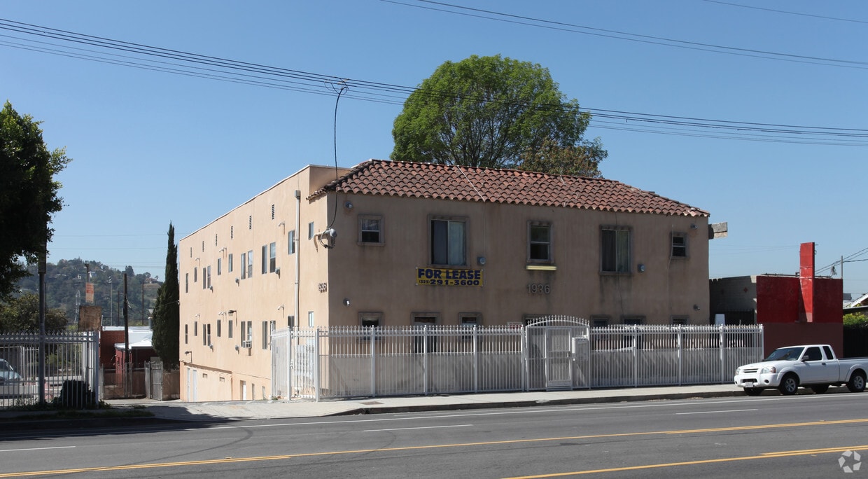

Discover your new home at 1936 Cypress Ave. You'll find this community in the Cypress Park area of Los Angeles. The professional leasing staff is eager to show you our community. Experience a better way of living at 1936 Cypress Ave. Contact us or stop by the leasing office to see available floor plans.
1936 Cypress Ave is an apartment community located in Los Angeles County and the 90065 ZIP Code. This area is served by the Los Angeles Unified Rocp School District attendance zone.
Air Conditioning
High Speed Internet Access
Smoke Free
Heating
Cypress Park is a community-oriented neighborhood just six miles north of Downtown Los Angeles. Residents bond at Rio de Los Angeles State Park or head outside the neighborhood for fun since Cypress Park isn’t far from some of LA’s local favorites like Dodger Stadium and Griffith Park. As you travel through Cypress Park, you’ll see murals and other public art adorning the walls of buildings and sidewalks, while authentic eateries with some of the best food in the city line the streets. The neighborhood has Mediterranean-style houses, apartments, and townhomes available for rent. Along with its affordability, Cypress Park is a rising neighborhood gaining attention for its proximity to the LA River and several development projects are already underway.
Learn more about living in Cypress ParkCompare neighborhood and city base rent averages by bedroom.
| Cypress Park | Los Angeles, CA | |
|---|---|---|
| Studio | $1,024 | $1,710 |
| 1 Bedroom | $1,382 | $2,178 |
| 2 Bedrooms | $1,985 | $3,017 |
| 3 Bedrooms | $3,429 | $4,259 |
| Colleges & Universities | Distance | ||
|---|---|---|---|
| Colleges & Universities | Distance | ||
| Drive: | 6 min | 3.0 mi | |
| Drive: | 7 min | 3.6 mi | |
| Drive: | 8 min | 4.9 mi | |
| Drive: | 10 min | 6.7 mi |


Transportation options available in Los Angeles include Lincoln Heights/Cypress Park Station, located 1.7 miles from 1936 Cypress Ave. 1936 Cypress Ave is near Bob Hope, located 13.8 miles or 19 minutes away, and Los Angeles International, located 18.9 miles or 30 minutes away.
| Transit / Subway | Distance | ||
|---|---|---|---|
| Transit / Subway | Distance | ||
|
|
Drive: | 3 min | 1.7 mi |
|
|
Drive: | 5 min | 2.6 mi |
|
|
Drive: | 5 min | 2.8 mi |
|
|
Drive: | 5 min | 3.3 mi |
|
|
Drive: | 8 min | 4.3 mi |
| Commuter Rail | Distance | ||
|---|---|---|---|
| Commuter Rail | Distance | ||
|
|
Drive: | 4 min | 2.3 mi |
|
|
Drive: | 7 min | 3.9 mi |
|
|
Drive: | 9 min | 3.9 mi |
| Drive: | 11 min | 8.0 mi | |
|
|
Drive: | 12 min | 8.4 mi |
| Airports | Distance | ||
|---|---|---|---|
| Airports | Distance | ||
|
Bob Hope
|
Drive: | 19 min | 13.8 mi |
|
Los Angeles International
|
Drive: | 30 min | 18.9 mi |
Scores provided by
Traffic
-Airport
-Businesses
-Scores provided by
HowLoud What is a Sound Score Rating? A Sound Score Rating aggregates noise caused by vehicle traffic, airplane traffic and local sources. How It WorksTime and distance from 1936 Cypress Ave.
| Shopping Centers | Distance | ||
|---|---|---|---|
| Shopping Centers | Distance | ||
| Walk: | 16 min | 0.8 mi | |
| Drive: | 2 min | 1.2 mi | |
| Drive: | 4 min | 2.0 mi |
| Parks and Recreation | Distance | ||
|---|---|---|---|
| Parks and Recreation | Distance | ||
|
Elyria Canyon Park
|
Walk: | 18 min | 1.0 mi |
|
Marsh Park
|
Drive: | 6 min | 2.4 mi |
|
Audubon Center at Debs Park
|
Drive: | 6 min | 3.3 mi |
|
Chavez Ravine Arboretum
|
Drive: | 5 min | 3.5 mi |
|
Elysian Park
|
Drive: | 9 min | 3.7 mi |
| Hospitals | Distance | ||
|---|---|---|---|
| Hospitals | Distance | ||
| Drive: | 3 min | 2.3 mi | |
| Drive: | 6 min | 3.6 mi | |
| Drive: | 6 min | 3.8 mi |
| Military Bases | Distance | ||
|---|---|---|---|
| Military Bases | Distance | ||
| Drive: | 27 min | 20.5 mi |
Pets Allowed Fitness Center Pool In Unit Washer & Dryer Clubhouse Balcony
What Are Walk Score®, Transit Score®, and Bike Score® Ratings?
Walk Score® measures the walkability of any address. Transit Score® measures access to public transit. Bike Score® measures the bikeability of any address.
What is a Sound Score Rating?
A Sound Score Rating aggregates noise caused by vehicle traffic, airplane traffic and local sources.

1936 Cypress Ave
Los Angeles, CA 90065


 - Violet on Virgil")
