
$1,850
/ Month
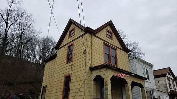
1931 State Ave
Cincinnati, OH 45204
Today
|
Edit
Favorites
513-586-2488
-
Bedrooms
3
-
Bathrooms
1.5
-
Square Feet
1,800 sq ft
-
Available
Available Now
Highlights
- Security System
- Attic
1931 State Ave

Favorites
About This Home
12 Month Lease,
$1,850 deposit,
Available Now
spacious 3 bedrooms, 1 attic, 1 kitchen/dining room
1931 State Ave is a house located in Hamilton County and the 45204 ZIP Code.
* Price shown is base rent. Excludes user-selected optional fees and variable or usage-based fees and required charges due at or prior to move-in or at move-out. Price, availability, fees, and any applicable rent special are subject to change without notice.
* Square footage definitions vary. Displayed square footage is approximate.
House Features
Washer/Dryer
Ceiling Fans
Security System
Heating
- Washer/Dryer
- Heating
- Ceiling Fans
- Security System
- Handrails
- Kitchen
- Dining Room
- Attic
Fees and Policies
The fees below are based on community-supplied data and may exclude additional fees and utilities.
- Parking
-
Surface Lot--
Details
Utilities Included
-
Trash Removal
Contact
- Phone Number
Location
Get Directions
Filled with historic shotgun houses, South Fairmount was first settled in the early 1800s. This large neighborhood is bordered by Mill Creek, directly west of Downtown Cincinnati and minutes from the University of Cincinnati. With just two miles to downtown, residents of South Fairmount enjoy fast access to all of Cincinnati's attractions, including the Cincinnati Zoo, Paul Brown Stadium (home of the Cincinnati Bengals), and the Cincinnati Music Hall.
Apartments in South Fairmount are near the Ohio River and several riverfront parks, including Embshoff Woods and Nature Preserve and the popular Eden Park, home of the Cincinnati Playhouse and the Cincinnati Art Museum.
Learn more about living in South Fairmount
Education
| Colleges & Universities | Distance | ||
|---|---|---|---|
| Colleges & Universities | Distance | ||
| Drive: | 7 min | 3.0 mi | |
| Drive: | 9 min | 3.3 mi | |
| Drive: | 9 min | 3.5 mi | |
| Drive: | 15 min | 5.6 mi |
1931 State Ave is within 7 minutes or 3.0 miles from University of Cincinnati. It is also near Cincinnati State and Univ. of Cincinnati, Medical.
Transportation options available in Cincinnati include Brewery District Station, Elm & Henry, located 2.0 miles from 1931 State Ave. 1931 State Ave is near Cincinnati/Northern Kentucky International, located 16.3 miles or 29 minutes away.
| Transit / Subway | Distance | ||
|---|---|---|---|
| Transit / Subway | Distance | ||
| Drive: | 4 min | 2.0 mi | |
| Drive: | 5 min | 2.2 mi | |
| Drive: | 5 min | 2.2 mi | |
| Drive: | 5 min | 2.3 mi | |
| Drive: | 5 min | 2.5 mi |
| Commuter Rail | Distance | ||
|---|---|---|---|
| Commuter Rail | Distance | ||
|
|
Drive: | 5 min | 2.2 mi |
| Airports | Distance | ||
|---|---|---|---|
| Airports | Distance | ||
|
Cincinnati/Northern Kentucky International
|
Drive: | 29 min | 16.3 mi |
Time and distance from 1931 State Ave.
| Shopping Centers | Distance | ||
|---|---|---|---|
| Shopping Centers | Distance | ||
| Walk: | 17 min | 0.9 mi | |
| Drive: | 5 min | 2.0 mi | |
| Drive: | 5 min | 2.0 mi |
1931 State Ave has 3 shopping centers within 2.0 miles, which is about a 5-minute drive. The miles and minutes will be for the farthest away property.
| Parks and Recreation | Distance | ||
|---|---|---|---|
| Parks and Recreation | Distance | ||
|
Wilson Commons
|
Drive: | 6 min | 2.1 mi |
|
Duke Energy Children's Museum
|
Drive: | 5 min | 2.2 mi |
|
Museum of Natural History and Science
|
Drive: | 5 min | 2.2 mi |
|
OMNIMAX Theater
|
Drive: | 5 min | 2.2 mi |
|
Cincinnati History Museum
|
Drive: | 5 min | 2.2 mi |
1931 State Ave has 5 parks within 2.2 miles, including Wilson Commons, Duke Energy Children's Museum, and Museum of Natural History and Science.
| Hospitals | Distance | ||
|---|---|---|---|
| Hospitals | Distance | ||
| Drive: | 7 min | 3.0 mi | |
| Drive: | 6 min | 3.0 mi | |
| Drive: | 9 min | 3.5 mi |
1931 State Ave has 3 hospitals within 3.5 miles, the nearest is Christ Hospital which is 3.0 miles away and a 7 minute drive.
| Military Bases | Distance | ||
|---|---|---|---|
| Military Bases | Distance | ||
| Drive: | 70 min | 54.2 mi | |
| Drive: | 76 min | 59.3 mi | |
| Drive: | 79 min | 62.5 mi |
1931 State Ave has 3 military bases within 62.5 miles, the nearest is Gentile Air Force Station which is 54.2 miles away and a 70 minute drive.
Amenities
- Washer/Dryer
- Heating
- Ceiling Fans
- Security System
- Handrails
- Kitchen
- Dining Room
- Attic
1931 State Ave Photos
What Are Walk Score®, Transit Score®, and Bike Score® Ratings?
Walk Score® measures the walkability of any address. Transit Score® measures access to public transit. Bike Score® measures the bikeability of any address.
What is a Sound Score Rating?
A Sound Score Rating aggregates noise caused by vehicle traffic, airplane traffic and local sources
1931 State Ave
Cincinnati, OH 45204