
$1,695
/ Month
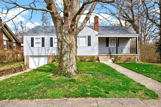
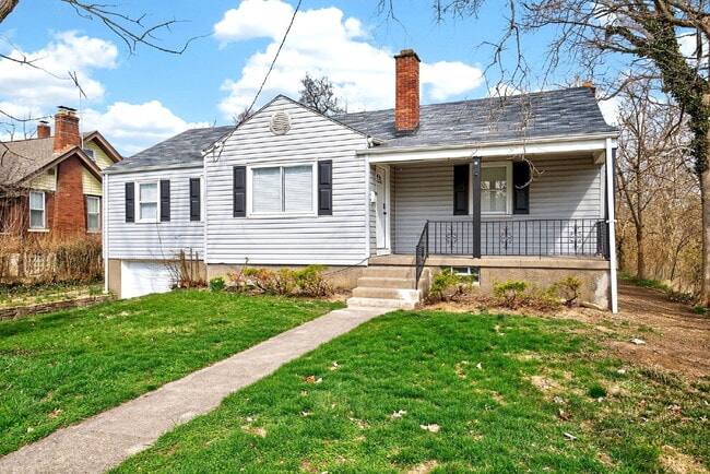
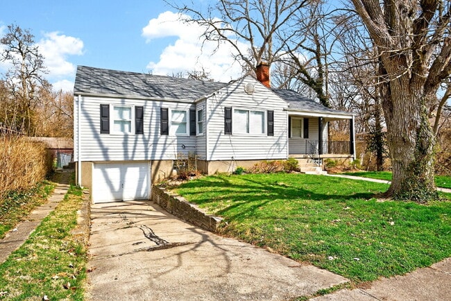
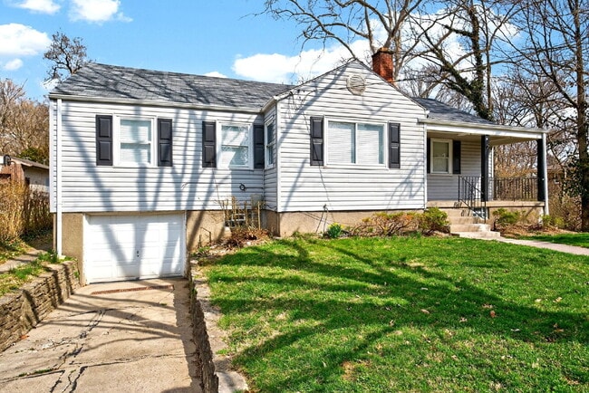
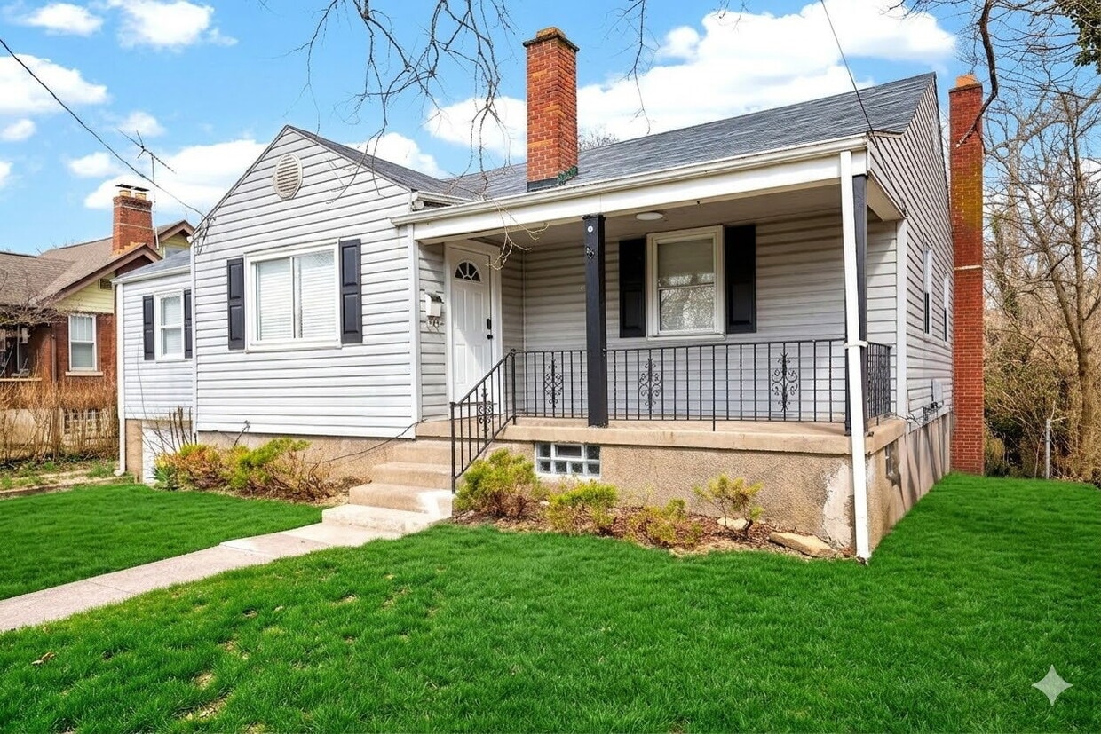
1930 Stevens Ave
Cincinnati, OH 45231
Today
|
Edit
Favorites
513-444-4010
-
Bedrooms
3
-
Bathrooms
1.5
-
Square Feet
--
-
Available
Available Now
1930 Stevens Ave

Favorites
About This Home
Available Now
Recently renovated 3 Bed/ 1.5 Bath House in Mt Healthy close to restaurants, parks, stores, and entertainment. This home features: Fresh paint; updated kitchen with SS appliances; extra room with decorative fireplace; partially finished basement; washer & dryer hookups; attached garage; partially fenced-in backyard; and more! *Pet Friendly(Small Pets Only)* In addition to rent, there is a mandatory Resident Benefit Package ($29 per month), which includes: - $100,000 liability coverage on the property - $10,000 in tenant personal property coverage - HVAC filters delivered to your unit to be changed out quarterly (if applicable) - Free ACH payments - Credit reporting of rent payments to help improve credit - Tenant & Maintenance Portals -Resident Concierge Service to help tenants save money on frequently used services *Multiple Security Deposit options/alternatives available *See Application Terms & Conditions on for other charges *$49 Application Fee per adult
1930 Stevens Ave is an apartment community located in Hamilton County and the 45231 ZIP Code.
* Price shown is base rent. Excludes user-selected optional fees and variable or usage-based fees and required charges due at or prior to move-in or at move-out. Price, availability, fees, and any applicable rent special are subject to change without notice.
* Square footage definitions vary. Displayed square footage is approximate.
Fees and Policies
The fees listed below are community-provided and may exclude utilities or add-ons. All payments are made directly to the property and are non-refundable unless otherwise specified.
-
Dogs
-
Allowed
-
Property Fee Disclaimer: Based on community-supplied data and independent market research. Subject to change without notice. May exclude fees for mandatory or optional services and usage-based utilities.
Contact
- Listed by EquityTeam
- Phone Number
- Contact
Location
Get Directions
Brentwood, a small community located in the northwestern portion of Springfield Township’s Finneytown neighborhood, sits in Hamilton County approximately 16 miles northeast of Downtown Cincinnati. Modest homes from the late 1940s line the tidy streets of the neighborhood, some with attached garages, fenced-in backyards, and private driveways.
Residents appreciate the neighborhood’s homey atmosphere, affordable housing options, and good school system. Also, State Route 126 runs through the southern portion of Brentwood, making it easy for residents to commute to and from Cincinnati.
Learn more about living in Brentwood
Education
| Colleges & Universities | Distance | ||
|---|---|---|---|
| Colleges & Universities | Distance | ||
| Drive: | 19 min | 8.6 mi | |
| Drive: | 17 min | 9.5 mi | |
| Drive: | 18 min | 10.4 mi | |
| Drive: | 20 min | 11.7 mi |
1930 Stevens Ave is within 19 minutes or 8.6 miles from Cincinnati State. It is also near Univ. of Cincinnati, Medical and Xavier University.
Transportation options available in Cincinnati include Findlay Market-Race Station - Race & Elder, located 10.2 miles from 1930 Stevens Ave. 1930 Stevens Ave is near Cincinnati/Northern Kentucky International, located 28.5 miles or 46 minutes away.
| Transit / Subway | Distance | ||
|---|---|---|---|
| Transit / Subway | Distance | ||
| Drive: | 22 min | 10.2 mi | |
| Drive: | 22 min | 10.3 mi | |
| Drive: | 23 min | 14.7 mi | |
| Drive: | 23 min | 14.7 mi | |
| Drive: | 23 min | 14.9 mi |
| Commuter Rail | Distance | ||
|---|---|---|---|
| Commuter Rail | Distance | ||
|
|
Drive: | 22 min | 14.5 mi |
| Airports | Distance | ||
|---|---|---|---|
| Airports | Distance | ||
|
Cincinnati/Northern Kentucky International
|
Drive: | 46 min | 28.5 mi |
Time and distance from 1930 Stevens Ave.
| Shopping Centers | Distance | ||
|---|---|---|---|
| Shopping Centers | Distance | ||
| Drive: | 4 min | 1.3 mi | |
| Drive: | 3 min | 1.3 mi | |
| Drive: | 4 min | 1.4 mi |
1930 Stevens Ave has 3 shopping centers within 1.4 miles, which is about a 4-minute drive. The miles and minutes will be for the farthest away property.
| Parks and Recreation | Distance | ||
|---|---|---|---|
| Parks and Recreation | Distance | ||
|
LaBoiteaux Woods
|
Drive: | 10 min | 3.4 mi |
|
Farbach-Werner Nature Preserve
|
Drive: | 7 min | 3.7 mi |
|
Winton Woods Park
|
Drive: | 10 min | 4.1 mi |
|
Buttercup Valley
|
Drive: | 12 min | 4.5 mi |
|
Triple Creek Park
|
Drive: | 10 min | 4.7 mi |
1930 Stevens Ave has 5 parks within 4.7 miles, including Farbach-Werner Nature Preserve, LaBoiteaux Woods, and Winton Woods Park.
| Hospitals | Distance | ||
|---|---|---|---|
| Hospitals | Distance | ||
| Drive: | 10 min | 6.4 mi | |
| Drive: | 16 min | 7.5 mi | |
| Drive: | 14 min | 7.8 mi |
1930 Stevens Ave has 3 hospitals within 7.8 miles, the nearest is Summit Behavioral Healthcare which is 6.4 miles away and a 10 minute drive.
| Military Bases | Distance | ||
|---|---|---|---|
| Military Bases | Distance | ||
| Drive: | 65 min | 50.7 mi | |
| Drive: | 71 min | 55.7 mi | |
| Drive: | 74 min | 59.0 mi |
1930 Stevens Ave has 3 military bases within 59.0 miles, the nearest is Gentile Air Force Station which is 50.7 miles away and a 65 minute drive.
You May Also Like
Similar Rentals Nearby


What Are Walk Score®, Transit Score®, and Bike Score® Ratings?
Walk Score® measures the walkability of any address. Transit Score® measures access to public transit. Bike Score® measures the bikeability of any address.
What is a Sound Score Rating?
A Sound Score Rating aggregates noise caused by vehicle traffic, airplane traffic and local sources.
1930 Stevens Ave
Cincinnati, OH 45231