

$1,300
/ Month
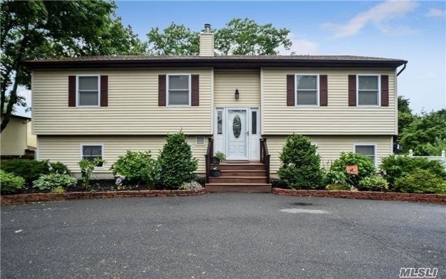
1888 Joshuas Path
Central Islip, NY 11722
Favorites
1888 Joshuas Path

Favorites
Check Back Soon for Upcoming Availability
| Beds | Baths | Average SF |
|---|---|---|
| 1 Bedroom 1 Bedroom 1 Br | 1 Bath 1 Bath 1 Ba | — |
About This Property
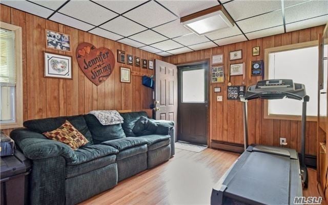
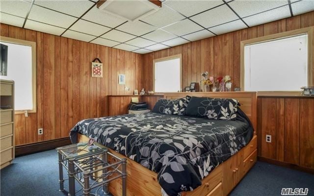
1st Floor Apartment In Hi Ranch, 1 Bedroom, 1 Bathroom, Combo Kitchen, Private Entrance, All Utilities Included.
1888 Joshuas Path is an apartment community located in Suffolk County and the 11722 ZIP Code.
1888 Joshuas Path,
Central Islip,
NY
11722
Central Islip sits squarely in the middle of Suffolk County, anchored by deep Long Island roots and a pace of life that moves a little slower than Manhattan's orbit without ever feeling cut off from it. The hamlet earned its name from the Long Island Rail Road's eastward push in the 1840s, and that same rail line still connects residents to Penn Station today. Touro Law School brings an academic presence to the area, and the nearby federal courthouse adds to Central Islip's role as a civic and legal hub for the region.
Neighborhoods here range from quiet residential streets lined with single-family homes to denser corridors closer to the town center. The housing mix reflects that range, with apartment communities, townhomes, and garden-style rentals offering real options at price points that tend to undercut much of the surrounding Town of Islip.
Learn more about living in Central Islip
Education
| Colleges & Universities | Distance | ||
|---|---|---|---|
| Colleges & Universities | Distance | ||
| Drive: | 7 min | 3.9 mi | |
| Drive: | 10 min | 4.4 mi | |
| Drive: | 18 min | 12.6 mi | |
| Drive: | 19 min | 12.6 mi |
1888 Joshuas Path is within 7 minutes or 3.9 miles from Touro University. It is also near SUNY Suffolk Co., Grant Campus and Stony Brook University.
Walkability Near 1888 Joshuas Path Central Islip, NY 11722
Getting Around
 What do Walkability, Transit, Drivability, and Bikeability mean?
Walkability measures the walking distance to day-to-day needs.
Transit measures access to public transportation.
Drivability measures congestion, parking availability, and access to major roads.
Bikeability measures the suitability for cycling.
How It Works
What do Walkability, Transit, Drivability, and Bikeability mean?
Walkability measures the walking distance to day-to-day needs.
Transit measures access to public transportation.
Drivability measures congestion, parking availability, and access to major roads.
Bikeability measures the suitability for cycling.
How It Works
Fairly Walkable
Walkability
50
/ 100
Limited Public Transit
Transit
30
/ 100
Exceptionally Drivable
Drivability
100
/ 100
Somewhat Bikeable
Bikeability
30
/ 100
Scores provided by
-
Soundscore™
-
/ 100
Traffic
-Airport
-Businesses
-Scores provided by
HowLoud What is a Sound Score Rating? A Sound Score Rating aggregates noise caused by vehicle traffic, airplane traffic and local sources. How It WorksYou May Also Like
-
121 Towne Apartments
121 Towne St
Stamford, CT 06902
$2,400 - $5,000 Total Monthly Price
1-3 Br 24.1 mi
-
Beacon Harbor Point
1 Harbor Point Rd
Stamford, CT 06902
$3,065 - $5,795 Total Monthly Price
1-2 Br 24.1 mi
-
The Parc at Glenbrook
66 Glenbrook Rd
Stamford, CT 06902
$2,350 - $3,375 Plus Fees
1-2 Br 12 Month Lease 24.5 mi
Similar Rentals Nearby
-
-
-
-
-
-
1 Bed$2,969+2 Beds$3,077+3 Beds$5,042+Total Monthly PriceTotal Monthly Price NewPrices include base rent and required monthly fees of $83. Variable costs based on usage may apply.Base Rent:1 Bed$2,885+2 Beds$2,993+3 Beds$4,958+
Pets Allowed Fitness Center Clubhouse
-
-
-
1 Bed$2,778+2 Beds$3,373+3 Beds$4,668+Total Monthly Price12 Month LeaseTotal Monthly Price NewPrices include base rent and required monthly fees of $103. Variable costs based on usage may apply.Base Rent:1 Bed$2,595+2 Beds$3,270+3 Beds$4,565+Specials
Pets Allowed Fitness Center Pool Dishwasher Refrigerator In Unit Washer & Dryer Walk-In Closets
-
1 Bed$2,795+2 Beds$4,495+Total Monthly PriceTotal Monthly Price NewPrices include required monthly fees of $100.Base Rent:1 Bed$2,695+2 Beds$4,395+
Fitness Center Pool In Unit Washer & Dryer Package Service Concierge EV Charging


What Are Walk Score®, Transit Score®, and Bike Score® Ratings?
Walk Score® measures the walkability of any address. Transit Score® measures access to public transit. Bike Score® measures the bikeability of any address.
What is a Sound Score Rating?
A Sound Score Rating aggregates noise caused by vehicle traffic, airplane traffic and local sources.

1888 Joshuas Path
Central Islip, NY 11722