$1,850
/ Month
1809 W Thompson St
Philadelphia, PA 19121
Today
|
Edit
Favorites
215-608-5485
-
Bedrooms
6
-
Bathrooms
2
-
Square Feet
--
-
Available
Available Now
1809 W Thompson St

Favorites
About This Home
Available Now
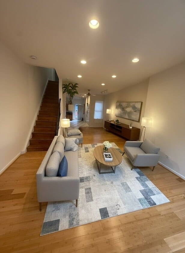
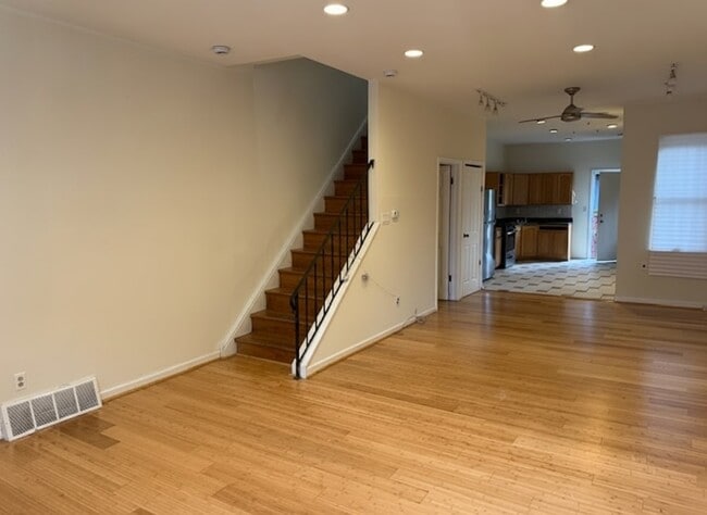
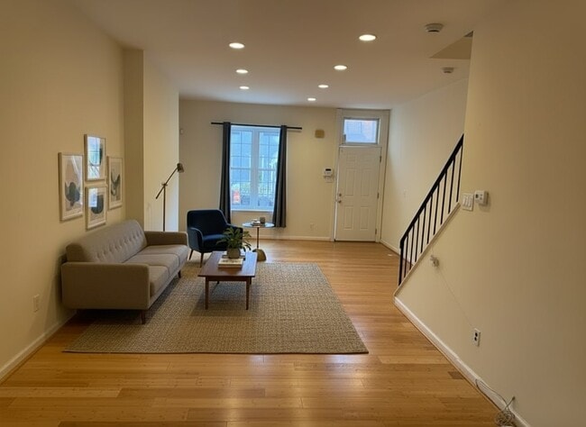
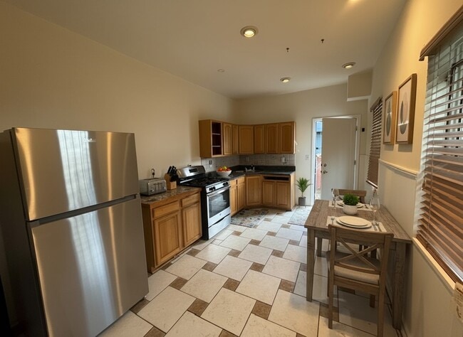
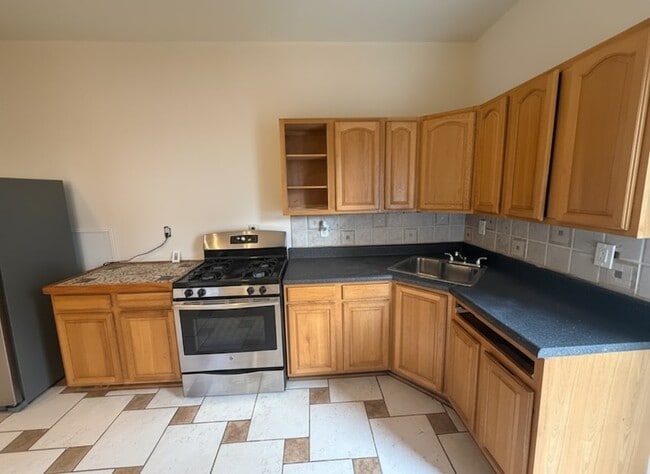
VIDEO TOUR HERE: Live at 1809 W Thompson St, a spacious 6-bedroom, 2-bath home in the heart of Brewerytown/Francisville. This large property offers plenty of room for shared living, featuring generous common areas and comfortable bedrooms throughout. Water is included in the rent, while tenants are responsible for gas and electric. Enjoy the convenience of being close to Girard College, local restaurants, cafés, shops, and public transit, making commuting and daily errands a breeze. Small pets are welcome (up to 2), with a $35/month fee per pet. Schedule your tour today! *Photos have bee touched up and staged
1809 W Thompson St is a house located in Philadelphia County and the 19121 ZIP Code. This area is served by the The School District of Philadelphia attendance zone.
* Price shown is base rent. Excludes user-selected optional fees and variable or usage-based fees and required charges due at or prior to move-in or at move-out. Price, availability, fees, and any applicable rent special are subject to change without notice.
* Square footage definitions vary. Displayed square footage is approximate.
Contact
- Listed by Deedee Rodriguez
- Phone Number
- Contact
Location
Get Directions
Running alongside Fairmount Park, North Philadelphia West encompasses the area between Girard and Lehigh Avenues, west of Broad Street. There’s an incredible diversity of rentals here, including modern apartments that display incredible architecture and amenities to long-standing brick townhomes. Residents delight in the wealth of outdoor opportunities afforded by their proximity to the park, including the Sedgley Woods disc golf course, home of the city's innovative blend of ultimate Frisbee and classic golf. The neighborhood includes the smaller residential areas of Stanton, Brewerytown and Strawberry Mansion, and counts Girard College and Temple University among its academic landmarks.
Learn more about living in North Philadelphia West
Education
| Colleges & Universities | Distance | ||
|---|---|---|---|
| Colleges & Universities | Distance | ||
| Walk: | 19 min | 1.0 mi | |
| Walk: | 19 min | 1.0 mi | |
| Drive: | 3 min | 1.4 mi | |
| Drive: | 5 min | 1.6 mi |
1809 W Thompson St is within 19 minutes or 1.0 mile from C.C. of Philadelphia. It is also near Temple University, Main Campus and Drexel Univ., Hahnemann.
Schools


Public Elementary & Middle School
Grades PK-8
296 Students
Attendance Zone
Public High School
Grades 9-12
466 Students
Attendance Zone
Private Elementary & Middle School
Grades PK-8
460 Students
Nearby
Private High School
Grades 9-12
902 Students
Nearby
School data provided by
 The GreatSchools Rating helps parents compare schools within a state based on a variety of school quality indicators and provides a helpful picture of how effectively each school serves all of its students. Ratings are on a scale of 1 (below average) to 10 (above average) and can include test scores, college readiness, academic progress, advanced courses, equity, discipline and attendance data. We also advise parents to visit schools, consider other information on school performance and programs, and consider family needs as part of the school selection process.
View GreatSchools Rating Methodology
Data provided by GreatSchools.org © 2025. All rights reserved.
View GreatSchools Rating Methodology
Data provided by GreatSchools.org © 2025. All rights reserved.
Transportation options available in Philadelphia include Girard Av & Ridge Av, located 0.2 mile from 1809 W Thompson St. 1809 W Thompson St is near Philadelphia International, located 13.7 miles or 24 minutes away, and Trenton Mercer, located 34.3 miles or 51 minutes away.
| Transit / Subway | Distance | ||
|---|---|---|---|
| Transit / Subway | Distance | ||
| Walk: | 3 min | 0.2 mi | |
| Walk: | 3 min | 0.2 mi | |
| Walk: | 4 min | 0.2 mi | |
| Walk: | 5 min | 0.3 mi | |
| Walk: | 5 min | 0.3 mi |
| Commuter Rail | Distance | ||
|---|---|---|---|
| Commuter Rail | Distance | ||
|
|
Drive: | 5 min | 1.7 mi |
|
|
Drive: | 5 min | 1.7 mi |
|
|
Drive: | 5 min | 1.8 mi |
|
|
Drive: | 5 min | 1.9 mi |
|
|
Drive: | 7 min | 2.3 mi |
| Airports | Distance | ||
|---|---|---|---|
| Airports | Distance | ||
|
Philadelphia International
|
Drive: | 24 min | 13.7 mi |
|
Trenton Mercer
|
Drive: | 51 min | 34.3 mi |
Time and distance from 1809 W Thompson St.
| Shopping Centers | Distance | ||
|---|---|---|---|
| Shopping Centers | Distance | ||
| Walk: | 12 min | 0.7 mi | |
| Walk: | 14 min | 0.7 mi | |
| Walk: | 18 min | 1.0 mi |
1809 W Thompson St has 3 shopping centers within 1.0 mile, which is about a 18-minute walk. The miles and minutes will be for the farthest away property.
| Parks and Recreation | Distance | ||
|---|---|---|---|
| Parks and Recreation | Distance | ||
|
Wagner Free Institute of Science
|
Walk: | 11 min | 0.6 mi |
|
Fels Planetarium
|
Drive: | 4 min | 1.5 mi |
|
Franklin Institute
|
Drive: | 4 min | 1.6 mi |
|
Edgar Allan Poe Nat'l Historic Site
|
Drive: | 4 min | 1.6 mi |
|
The Academy of Natural Sciences
|
Drive: | 4 min | 1.9 mi |
1809 W Thompson St has 5 parks within 1.9 miles, including Wagner Free Institute of Science, Fels Planetarium, and The Academy of Natural Sciences.
| Hospitals | Distance | ||
|---|---|---|---|
| Hospitals | Distance | ||
| Drive: | 3 min | 1.3 mi | |
| Drive: | 6 min | 2.2 mi | |
| Drive: | 6 min | 2.3 mi |
1809 W Thompson St has 3 hospitals within 2.3 miles, the nearest is Hahnemann University Hospital which is 1.3 miles away and a 3 minute drive.
| Military Bases | Distance | ||
|---|---|---|---|
| Military Bases | Distance | ||
| Drive: | 15 min | 8.1 mi |
1809 W Thompson St is 8.1 miles and a 15 minute drive from Philadelphia Naval Busi Center.
You May Also Like
Similar Rentals Nearby


What Are Walk Score®, Transit Score®, and Bike Score® Ratings?
Walk Score® measures the walkability of any address. Transit Score® measures access to public transit. Bike Score® measures the bikeability of any address.
What is a Sound Score Rating?
A Sound Score Rating aggregates noise caused by vehicle traffic, airplane traffic and local sources

1809 W Thompson St
Philadelphia, PA 19121