

$1,000
/ Month
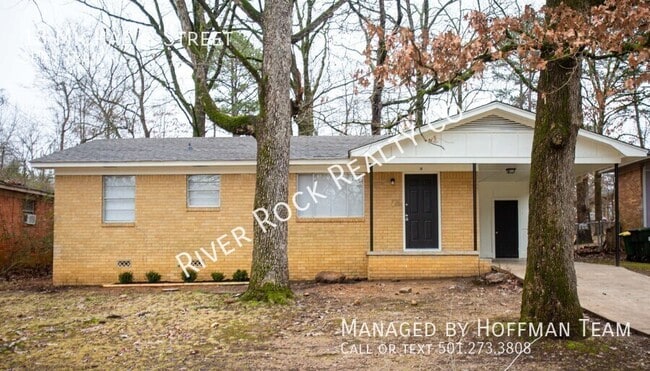
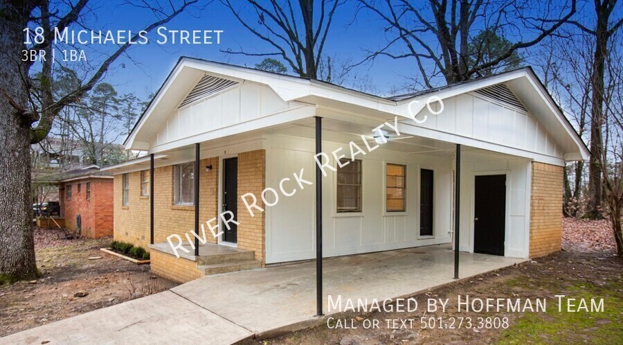
18 Michaels St
Little Rock, AR 72204
Today
|
Edit
Favorites
501-273-3808
-
Bedrooms
3
-
Bathrooms
1
-
Square Feet
888 sq ft
-
Available
Available Now
18 Michaels St

Favorites
About This Home
Available Now
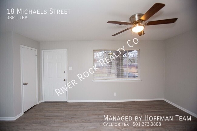
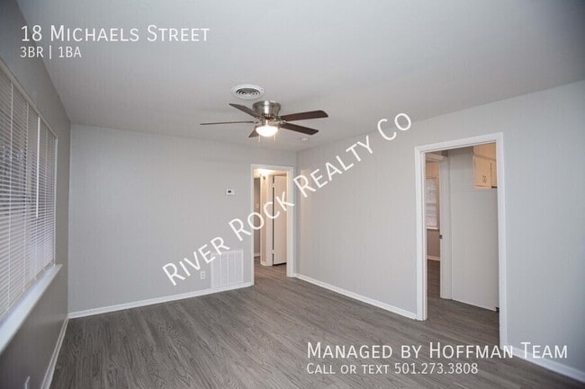
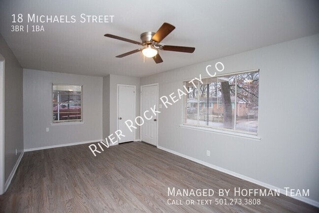
*MOVE IN SPECIAL! HALF OFF FIRST MONTH’S RENT! Cute 3BD/1BA located off Kanis close to Baptist Hospital. Perfect location for a medical professional. This property is managed by Hoffman Team so beware of scammers - we will never ask you to Cashapp us money. The lease for this property is for 18 months to 2 years with a 3% increase after the first year. Income must be 3x the amount of rent per month unless you have a housing voucher. Deposit, first month’s rent, and the $50 administration fee due before move in.
18 Michaels St is a house located in Pulaski County and the 72204 ZIP Code. This area is served by the Little Rock attendance zone.
* Price shown is base rent. Excludes user-selected optional fees and variable or usage-based fees and required charges due at or prior to move-in or at move-out. Price, availability, fees, and any applicable rent special are subject to change without notice.
* Square footage definitions vary. Displayed square footage is approximate.
Fees and Policies
The fees listed below are community-provided and may exclude utilities or add-ons. All payments are made directly to the property and are non-refundable unless otherwise specified.
-
Dogs
-
Allowed
-
-
Cats
-
Allowed
-
-
Other
-
Covered
Property Fee Disclaimer: Based on community-supplied data and independent market research. Subject to change without notice. May exclude fees for mandatory or optional services and usage-based utilities.
House Features
- Washer/Dryer Hookup
- Air Conditioning
- Disposal
Contact
- Listed by The Hoffman Team
- Phone Number
- Contact
Location
Get Directions
The Briarwood neighborhood is a vibrant residential community in central Little Rock offering prime access to the Capital City’s greatest resources and attractions. The University of Arkansas at Little Rock campus sits just a few blocks south, making Briarwood a terrific choice for students, faculty, and staff members. War Memorial Stadium is just a short walk east of the neighborhood, allowing you to easily get to Razorbacks football games and other special events hosted at the arena.
Briarwood is also centrally located between three major healthcare facilities, with CHI St. Vincent Infirmary, University of Arkansas Medical Center, and Baptist Health Medical Center – Little Rock all within a radius of less than a mile. Park Plaza Mall on the east side anchors an expansive network of shopping centers and restaurants.
Learn more about living in Briarwood
Amenities
- Washer/Dryer Hookup
- Air Conditioning
- Disposal
Education
| Colleges & Universities | Distance | ||
|---|---|---|---|
| Colleges & Universities | Distance | ||
| Drive: | 7 min | 3.1 mi | |
| Drive: | 8 min | 3.7 mi | |
| Drive: | 9 min | 5.6 mi | |
| Drive: | 20 min | 10.5 mi |
18 Michaels St is within 7 minutes or 3.1 miles from UA Little Rock. It is also near Univ. of Ark. Medical Scis. and Philander Smith College.
Schools


Public Elementary School
Grades K-5
332 Students
Attendance Zone
Public Middle School
Grades 6-8
521 Students
Attendance Zone
Public High School
Grades 9-12
1,081 Students
Nearby
Private Elementary & Middle School
Grades PK-8
143 Students
Nearby
Private Elementary, Middle & High School
Grades PK-11
54 Students
Nearby
Private Elementary, Middle & High School
Grades 1-12
Nearby
School data provided by
 The GreatSchools Rating helps parents compare schools within a state based on a variety of school quality indicators and provides a helpful picture of how effectively each school serves all of its students. Ratings are on a scale of 1 (below average) to 10 (above average) and can include test scores, college readiness, academic progress, advanced courses, equity, discipline and attendance data. We also advise parents to visit schools, consider other information on school performance and programs, and consider family needs as part of the school selection process.
View GreatSchools Rating Methodology
Data provided by GreatSchools.org © 2026. All rights reserved.
View GreatSchools Rating Methodology
Data provided by GreatSchools.org © 2026. All rights reserved.
Transportation options available in Little Rock include 2Nd St & Center St, located 6.4 miles from 18 Michaels St. 18 Michaels St is near Bill and Hillary Clinton Ntl/Adams Field, located 10.3 miles or 17 minutes away.
| Transit / Subway | Distance | ||
|---|---|---|---|
| Transit / Subway | Distance | ||
| Drive: | 10 min | 6.4 mi | |
| Drive: | 10 min | 6.4 mi | |
| Drive: | 10 min | 6.7 mi | |
| Drive: | 11 min | 6.8 mi | |
| Drive: | 11 min | 7.2 mi |
| Commuter Rail | Distance | ||
|---|---|---|---|
| Commuter Rail | Distance | ||
|
|
Drive: | 10 min | 5.6 mi |
| Airports | Distance | ||
|---|---|---|---|
| Airports | Distance | ||
|
Bill and Hillary Clinton Ntl/Adams Field
|
Drive: | 17 min | 10.3 mi |
Time and distance from 18 Michaels St.
| Shopping Centers | Distance | ||
|---|---|---|---|
| Shopping Centers | Distance | ||
| Walk: | 7 min | 0.4 mi | |
| Walk: | 20 min | 1.1 mi | |
| Drive: | 3 min | 1.5 mi |
18 Michaels St has 3 shopping centers within 1.5 miles, which is about a 3-minute drive. The miles and minutes will be for the farthest away property.
| Parks and Recreation | Distance | ||
|---|---|---|---|
| Parks and Recreation | Distance | ||
|
Little Rock Zoo
|
Drive: | 6 min | 2.8 mi |
|
Central High School National Historic Site
|
Drive: | 8 min | 4.6 mi |
|
Museum of Discovery
|
Drive: | 11 min | 7.0 mi |
|
Central Arkansas Nature Center
|
Drive: | 11 min | 7.0 mi |
|
Burns Park
|
Drive: | 18 min | 11.9 mi |
18 Michaels St has 5 parks within 11.9 miles, including Little Rock Zoo, Central High School National Historic Site, and Museum of Discovery.
| Hospitals | Distance | ||
|---|---|---|---|
| Hospitals | Distance | ||
| Drive: | 4 min | 1.9 mi | |
| Drive: | 7 min | 3.3 mi | |
| Drive: | 7 min | 3.5 mi |
18 Michaels St has 3 hospitals within 3.5 miles, the nearest is Arkansas Heart Hospital which is 1.9 miles away and a 4 minute drive.
| Military Bases | Distance | ||
|---|---|---|---|
| Military Bases | Distance | ||
| Drive: | 33 min | 19.1 mi | |
| Drive: | 38 min | 24.5 mi | |
| Drive: | 38 min | 26.7 mi |
18 Michaels St has 3 military bases within 26.7 miles, the nearest is Camp Joseph T. Robinson Hill which is 19.1 miles away and a 33 minute drive.
You May Also Like
Similar Rentals Nearby


What Are Walk Score®, Transit Score®, and Bike Score® Ratings?
Walk Score® measures the walkability of any address. Transit Score® measures access to public transit. Bike Score® measures the bikeability of any address.
What is a Sound Score Rating?
A Sound Score Rating aggregates noise caused by vehicle traffic, airplane traffic and local sources
18 Michaels St
Little Rock, AR 72204