
Groove Lofts
608 2nd Ave S,
Minneapolis, MN 55402
$1,338 - $2,361 Plus Fees
Studio - 4 Beds

Bedrooms
2 bd
Bathrooms
1 ba
Square Feet
900 sq ft
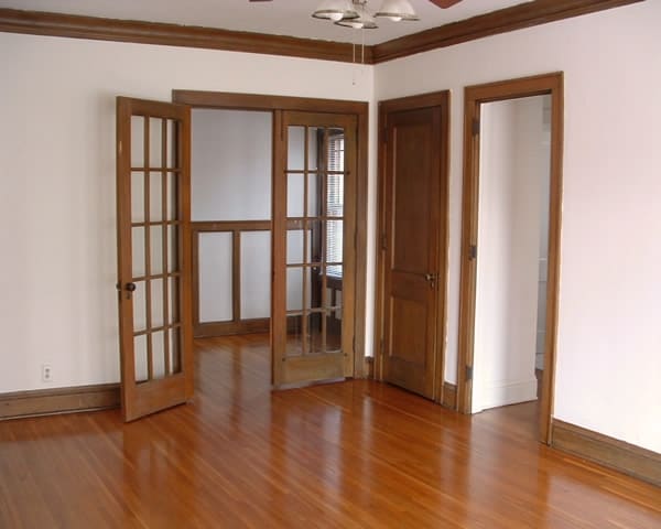
1920’s grand brick building naturally fits well in the middle of upscale Lowry Hill. Named after Thomas Lowry, a late nineteenth century real estate mogul and trolley tycoon. A recently renovated entryway instantly welcomes you home. You and your cat (s) (2 allowed) and/or fish will be enamored by the natural wood, high ceilings, hardwood floors and built-in cabinets. Enjoy walking to Thomas Lowry Park nearby; leisurely strolling the brick paths, adorned with the sights of a grape arbor, seven soothing cascading pools and alluring plantings. The #6 and #25 bus stops are quite close.
1920’s grand brick building naturally fits well in the middle of upscale Lowry Hill. Named after Thomas Lowry, a late nineteenth century real estate mogul and trolley tycoon. A recently renovated entryway instantly welcomes you home. You and your cat (s) (2 allowed) and/or fish will be enamored by the natural wood, high ceilings, hardwood floors and built-in cabinets. Enjoy walking to Thomas Lowry Park nearby; leisurely strolling the brick paths, adorned with the sights of a grape arbor, seven soothing cascading pools and alluring plantings. The #6 and #25 bus stops are quite close.
1785 Bryant Ave S is an apartment community located in Hennepin County and the 55403 ZIP Code. This area is served by the Minneapolis Public School Dist. attendance zone.
Hardwood Floors
Refrigerator
Heating
Range
Within the Calhoun-Isles community, Lowry Hill sits just west of Downtown Minneapolis. The population of this area provides a close-knit community of approximately 4,000 residents. Defined by its historical architecture, Lowry Hill's houses display a Victorian style. However, other styles, such as Prairie and Romanesque, make appearances, too. There are upscale apartment communities available here as well, making Lowry Hill an increasingly popular option for those who want to remain close to the city center.
Learn more about living in Lowry HillCompare neighborhood and city base rent averages by bedroom.
| Lowry Hill | Minneapolis, MN | |
|---|---|---|
| Studio | $947 | $1,133 |
| 1 Bedroom | $1,195 | $1,402 |
| 2 Bedrooms | $1,616 | $2,090 |
| 3 Bedrooms | $1,529 | $2,405 |
| Colleges & Universities | Distance | ||
|---|---|---|---|
| Colleges & Universities | Distance | ||
| Walk: | 13 min | 0.7 mi | |
| Drive: | 4 min | 1.2 mi | |
| Drive: | 5 min | 1.7 mi | |
| Drive: | 6 min | 3.4 mi |


Transportation options available in Minneapolis include Warehouse District/Hennepin Avenue Station, located 1.5 miles from 1785 Bryant Ave S. 1785 Bryant Ave S is near Minneapolis-St Paul International/Wold-Chamberlain, located 11.3 miles or 21 minutes away.
| Transit / Subway | Distance | ||
|---|---|---|---|
| Transit / Subway | Distance | ||
|
|
Drive: | 5 min | 1.5 mi |
|
|
Drive: | 5 min | 1.7 mi |
|
|
Drive: | 5 min | 1.7 mi |
| Drive: | 5 min | 2.0 mi | |
|
|
Drive: | 6 min | 2.0 mi |
| Commuter Rail | Distance | ||
|---|---|---|---|
| Commuter Rail | Distance | ||
|
|
Drive: | 6 min | 2.0 mi |
|
|
Drive: | 14 min | 8.8 mi |
|
|
Drive: | 17 min | 11.2 mi |
|
|
Drive: | 29 min | 20.0 mi |
|
|
Drive: | 30 min | 21.6 mi |
| Airports | Distance | ||
|---|---|---|---|
| Airports | Distance | ||
|
Minneapolis-St Paul International/Wold-Chamberlain
|
Drive: | 21 min | 11.3 mi |
Scores provided by
Traffic
-Airport
-Businesses
-Scores provided by
HowLoud What is a Sound Score Rating? A Sound Score Rating aggregates noise caused by vehicle traffic, airplane traffic and local sources. How It WorksTime and distance from 1785 Bryant Ave S.
| Shopping Centers | Distance | ||
|---|---|---|---|
| Shopping Centers | Distance | ||
| Walk: | 9 min | 0.5 mi | |
| Walk: | 15 min | 0.8 mi | |
| Walk: | 16 min | 0.8 mi |
| Parks and Recreation | Distance | ||
|---|---|---|---|
| Parks and Recreation | Distance | ||
|
Thomas Lowry Park
|
Walk: | 1 min | 0.1 mi |
|
Minneapolis Sculpture Garden
|
Walk: | 7 min | 0.4 mi |
|
Cowles Conservatory
|
Walk: | 8 min | 0.4 mi |
|
Loring Park
|
Walk: | 13 min | 0.7 mi |
|
Mueller Park
|
Walk: | 13 min | 0.7 mi |
| Hospitals | Distance | ||
|---|---|---|---|
| Hospitals | Distance | ||
| Drive: | 6 min | 2.0 mi | |
| Drive: | 6 min | 2.1 mi | |
| Drive: | 7 min | 2.4 mi |
| Military Bases | Distance | ||
|---|---|---|---|
| Military Bases | Distance | ||
| Drive: | 16 min | 8.3 mi |
Pets Allowed Fitness Center Pool Dishwasher Refrigerator Clubhouse Maintenance on site
Pets Allowed Fitness Center Dishwasher Refrigerator Kitchen In Unit Washer & Dryer
Pets Allowed Fitness Center Pool In Unit Washer & Dryer Stainless Steel Appliances Hardwood Floors
What Are Walk Score®, Transit Score®, and Bike Score® Ratings?
Walk Score® measures the walkability of any address. Transit Score® measures access to public transit. Bike Score® measures the bikeability of any address.
What is a Sound Score Rating?
A Sound Score Rating aggregates noise caused by vehicle traffic, airplane traffic and local sources.
1785 Bryant Ave S
Minneapolis, MN 55403


