

$2,550 / Month
1775 Panda Way Unit 345
Hayward, CA 94541
2 Weeks Ago
Favorites
1775 Panda Way Unit 345

Favorites
Check Back Soon for Upcoming Availability
| Beds | Baths | Average SF |
|---|---|---|
| 2 Bedrooms 2 Bedrooms 2 Br | 2 Baths 2 Baths 2 Ba | 898 SF |
About This Property
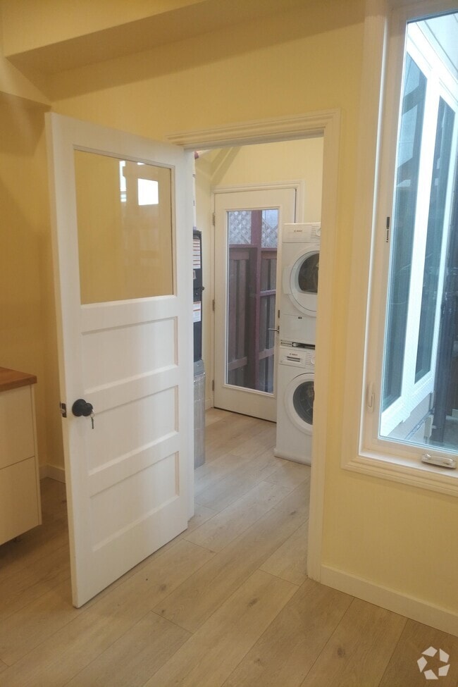
New Vinyl wood floors, top floor balcony overlooks picturesque serene hillsides and end unit. Dishwasher, stove , garbage disposal. Fireplace, cable and pool. Two cars per unit - one in secure building garage and one outdoor space in Parking lot. HOA covers common hot water, trash, water/sewer.
1775 Panda Way is a condo located in Alameda County and the 94541 ZIP Code. This area is served by the Hayward Unified attendance zone.

1775 Panda
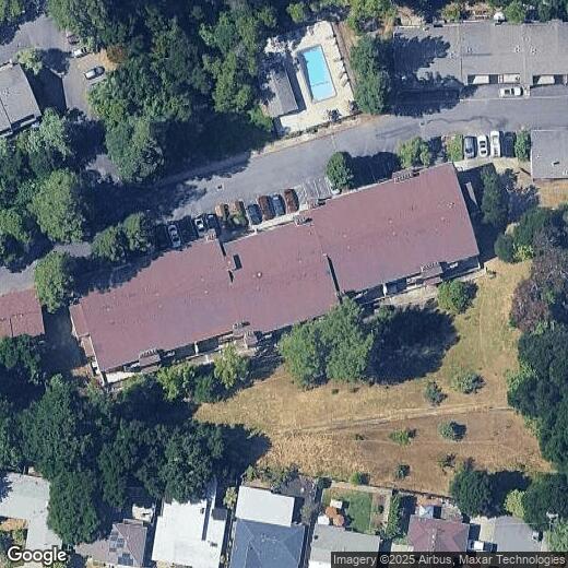
45 Units
2 Stories
Built in 1980
40,455 Sq Ft
Built in 1980, 1775 Panda Way is a cozy, 50-unit condominium complex nestled in Hayward's Upper B Street neighborhood. The two-story building offers residents a comfortable living experience with a touch of nature, thanks to its proximity to Sulpher Creek Nature Center just across the street. With recent updates to many of the units, including fresh paint, new carpeting, and modern finishes in the kitchens and bathrooms, 1775 Panda Way provides a welcoming atmosphere for those seeking a convenient and relaxed lifestyle.
Learn more about 1775 Panda
Location
Get Directions
Situated in the northeastern-most part of Hayward, Upper B Street offers plenty of affordable rental options and convenient amenities along with easy access to several nearby highways and BART stations. Aside from its remarkable accessibility, Upper B Street’s quiet boulevards lined with charming bungalows and mature trees make the neighborhood stand out.
Located about one mile northeast of Downtown Hayward, Upper B Street is surrounded by a host of lush green spaces for residents to enjoy as well as numerous urban amenities. Hayward Japanese Gardens, Sulphur Creek Nature Center, Don Castro Regional Recreation Area, and Lake Chabot Regional Park are all situated within close proximity to the neighborhood.
The many metropolitan delights of San Francisco are about 27 miles northwest of Upper B Street. Southland Mall offers a bevy of shopping and dining opportunities a little closer to home, sitting just three miles southwest of the neighborhood.
Learn more about living in Upper B StreetBelow are rent ranges for similar nearby apartments
Education
| Colleges & Universities | Distance | ||
|---|---|---|---|
| Colleges & Universities | Distance | ||
| Drive: | 8 min | 3.0 mi | |
| Drive: | 11 min | 4.6 mi | |
| Drive: | 21 min | 12.2 mi | |
| Drive: | 24 min | 14.5 mi |
1775 Panda Way Unit 345 is within 8 minutes or 3.0 miles from Cal State East Bay. It is also near Chabot College and Mills College.
Schools


Charter Elementary School
Grades K-5
483 Students
Nearby
Public Elementary School
Grades K-6
426 Students
Attendance Zone
Public Middle School
Grades 7-8
545 Students
Attendance Zone
Public High School
Grades 9-12
1,712 Students
Attendance Zone
Private Elementary, Middle & High School
Grades 1-12
Nearby
Private Elementary & Middle School
Grades K-8
203 Students
Nearby
Private Middle & High School
Grades 7 & 9-11
Nearby
Private Middle & High School
Grades 9
Nearby
School data provided by
 The GreatSchools Rating helps parents compare schools within a state based on a variety of school quality indicators and provides a helpful picture of how effectively each school serves all of its students. Ratings are on a scale of 1 (below average) to 10 (above average) and can include test scores, college readiness, academic progress, advanced courses, equity, discipline and attendance data. We also advise parents to visit schools, consider other information on school performance and programs, and consider family needs as part of the school selection process.
View GreatSchools Rating Methodology
View GreatSchools Rating Methodology
Transportation options available in Hayward include Hayward Station, located 1.6 miles from 1775 Panda Way Unit 345. 1775 Panda Way Unit 345 is near Metro Oakland International, located 11.4 miles or 18 minutes away, and San Francisco International, located 24.0 miles or 33 minutes away.
| Transit / Subway | Distance | ||
|---|---|---|---|
| Transit / Subway | Distance | ||
|
|
Drive: | 5 min | 1.6 mi |
|
|
Drive: | 7 min | 3.4 mi |
|
|
Drive: | 11 min | 4.2 mi |
|
|
Drive: | 10 min | 5.2 mi |
|
|
Drive: | 14 min | 8.7 mi |
| Commuter Rail | Distance | ||
|---|---|---|---|
| Commuter Rail | Distance | ||
|
|
Drive: | 7 min | 2.3 mi |
| Drive: | 7 min | 2.3 mi | |
| Drive: | 19 min | 11.2 mi | |
| Drive: | 21 min | 14.0 mi | |
|
|
Drive: | 21 min | 15.5 mi |
| Airports | Distance | ||
|---|---|---|---|
| Airports | Distance | ||
|
Metro Oakland International
|
Drive: | 18 min | 11.4 mi |
|
San Francisco International
|
Drive: | 33 min | 24.0 mi |
Time and distance from 1775 Panda Way Unit 345.
| Shopping Centers | Distance | ||
|---|---|---|---|
| Shopping Centers | Distance | ||
| Walk: | 16 min | 0.8 mi | |
| Walk: | 17 min | 0.9 mi | |
| Walk: | 19 min | 1.0 mi |
1775 Panda Way Unit 345 has 3 shopping centers within 1.0 miles, which is about a 19-minute walk. The miles and minutes will be for the farthest away property.
| Parks and Recreation | Distance | ||
|---|---|---|---|
| Parks and Recreation | Distance | ||
|
Sulphur Creek Nature Center
|
Drive: | 4 min | 1.1 mi |
|
Don Castro Regional Recreation Area
|
Drive: | 4 min | 1.6 mi |
|
Cull Canyon Regional Recreation Area
|
Drive: | 9 min | 3.2 mi |
|
Lake Chabot Regional Park
|
Drive: | 11 min | 5.0 mi |
|
Hayward Regional Shoreline
|
Drive: | 17 min | 8.0 mi |
1775 Panda Way Unit 345 has 5 parks within 8.0 miles, including Sulphur Creek Nature Center, Don Castro Regional Recreation Area, and Cull Canyon Regional Recreation Area.
| Hospitals | Distance | ||
|---|---|---|---|
| Hospitals | Distance | ||
| Drive: | 10 min | 4.5 mi | |
| Drive: | 9 min | 4.6 mi | |
| Drive: | 12 min | 7.7 mi |
1775 Panda Way Unit 345 has 3 hospitals within 7.7 miles, the nearest is St. Rose Hospital which is 4.5 miles away and a 10 minute drive.
| Military Bases | Distance | ||
|---|---|---|---|
| Military Bases | Distance | ||
| Drive: | 29 min | 18.9 mi |
1775 Panda Way Unit 345 is 18.9 miles and a 29 minute drive from Alameda/US Naval Air Station Alameda.
You May Also Like
Similar Rentals Nearby
What Are Walk Score®, Transit Score®, and Bike Score® Ratings?
Walk Score® measures the walkability of any address. Transit Score® measures access to public transit. Bike Score® measures the bikeability of any address.
What is a Sound Score Rating?
A Sound Score Rating aggregates noise caused by vehicle traffic, airplane traffic and local sources
1775 Panda Way
Hayward, CA 94541