
$3,000
/ Month
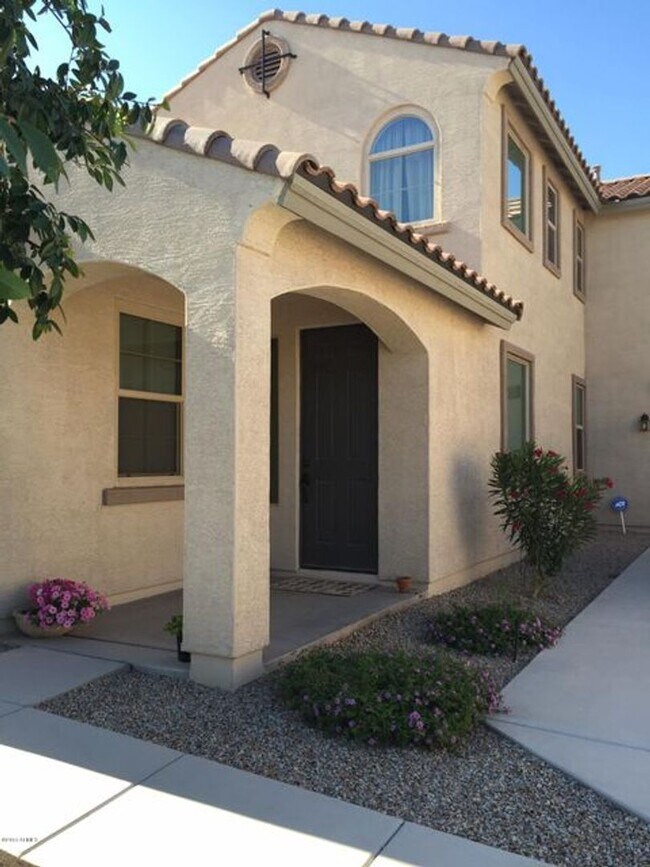
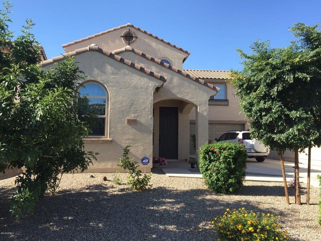
1765 W Pelican Dr
Chandler, AZ 85286
Today
|
Edit
Favorites
480-650-0688
-
Bedrooms
4
-
Bathrooms
3
-
Square Feet
2,096 sq ft
-
Available
Available Jun 1
1765 W Pelican Dr

Favorites
About This Home
$3,000 deposit,
Available Jun 1
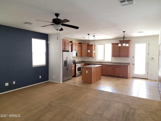
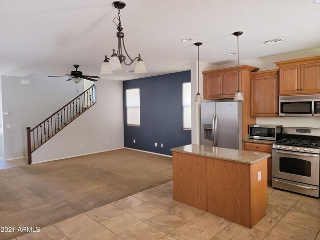
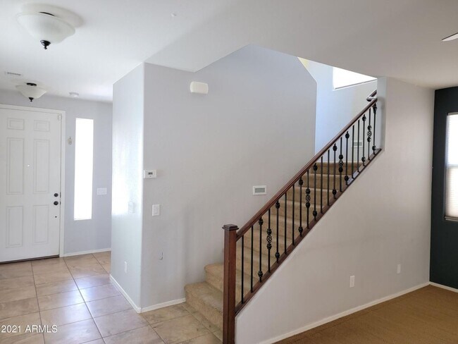
Gorgeous 4 Bed 3 Bath home located in a desirable community in Chandler. Best school district! This is a spacious floorplan with great room, large island kitchen, open layout and a 2 Car Garage. Open Kitchen offers upgraded cabinetry with crown molding, gas range, beautiful granite, and a large island. Pleasing paint colors that everyone will enjoy. One Full Bedroom and one Full Bathroom downstairs. The great room is pre-wired for surround sound. Spacious backyard features artificial turf and a low maintenance front yard! Community pool/parks included. Refrigerator included. MUST SEE!!
Unique Features
- Community Pool
- Community Park
1765 W Pelican Dr is a house located in Maricopa County and the 85286 ZIP Code. This area is served by the Chandler Unified District attendance zone.
* Price shown is base rent. Excludes user-selected optional fees and variable or usage-based fees and required charges due at or prior to move-in or at move-out. Price, availability, fees, and any applicable rent special are subject to change without notice.
* Square footage definitions vary. Displayed square footage is approximate.
Contact
- Listed by Rapido Realty LLC | Rapido Realty LLC
- Phone Number
- Contact
Location
Get Directions
Nestled between Downtown Chandler and the Gila River Indian Reservation, South Chandler is a sizeable suburban area brimming with all kinds of modern conveniences. South Chandler residents enjoy easy access to a slew of shopping centers and plazas, many of which are clustered along South Alma School Road and South Arizona Avenue.
South Chandler offers plenty of recreational opportunities at Tumbleweed Park, Chuparosa Park, Snedigar Recreation Center, and Paseo Vista Recreation Area. The expansive San Tan Mountains Regional Park is also just minutes away from South Chandler. A wide variety of golf and country clubs are located in South Chandler as well.
Learn more about living in South Chandler
Amenities
- Community Pool
- Community Park
Education
| Colleges & Universities | Distance | ||
|---|---|---|---|
| Colleges & Universities | Distance | ||
| Drive: | 9 min | 5.1 mi | |
| Drive: | 12 min | 6.5 mi | |
| Drive: | 17 min | 10.4 mi | |
| Drive: | 18 min | 11.4 mi |
1765 W Pelican Dr is within 9 minutes or 5.1 miles from Chandler-Gilbert CC. Sun Lakes. It is also near Chandler-Gilbert C.C., Pecos and Mesa C.C., Southern and Dobson.
Schools

Public Middle School
Grades 6-8
Nearby
Public High School
Grades 9-12
Nearby
School data provided by
 The GreatSchools Rating helps parents compare schools within a state based on a variety of school quality indicators and provides a helpful picture of how effectively each school serves all of its students. Ratings are on a scale of 1 (below average) to 10 (above average) and can include test scores, college readiness, academic progress, advanced courses, equity, discipline and attendance data. We also advise parents to visit schools, consider other information on school performance and programs, and consider family needs as part of the school selection process.
View GreatSchools Rating Methodology
Data provided by GreatSchools.org © 2026. All rights reserved.
View GreatSchools Rating Methodology
Data provided by GreatSchools.org © 2026. All rights reserved.
Transportation options available in Chandler include Price-101 Fwy/Apache Blvd, located 11.1 miles from 1765 W Pelican Dr. 1765 W Pelican Dr is near Phoenix-Mesa Gateway, located 13.9 miles or 22 minutes away, and Phoenix Sky Harbor International, located 19.2 miles or 28 minutes away.
| Transit / Subway | Distance | ||
|---|---|---|---|
| Transit / Subway | Distance | ||
|
|
Drive: | 16 min | 11.1 mi |
|
|
Drive: | 20 min | 11.6 mi |
|
|
Drive: | 17 min | 11.6 mi |
|
|
Drive: | 18 min | 12.2 mi |
|
|
Drive: | 19 min | 13.0 mi |
| Commuter Rail | Distance | ||
|---|---|---|---|
| Commuter Rail | Distance | ||
|
|
Drive: | 29 min | 21.4 mi |
| Airports | Distance | ||
|---|---|---|---|
| Airports | Distance | ||
|
Phoenix-Mesa Gateway
|
Drive: | 22 min | 13.9 mi |
|
Phoenix Sky Harbor International
|
Drive: | 28 min | 19.2 mi |
Getting Around
 What do Walkability, Transit, Drivability, and Bikeability mean?
Walkability measures the walking distance to day-to-day needs.
Transit measures access to public transportation.
Drivability measures congestion, parking availability, and access to major roads.
Bikeability measures the suitability for cycling.
How It Works
What do Walkability, Transit, Drivability, and Bikeability mean?
Walkability measures the walking distance to day-to-day needs.
Transit measures access to public transportation.
Drivability measures congestion, parking availability, and access to major roads.
Bikeability measures the suitability for cycling.
How It Works
Fairly Walkable
Walkability
40
/ 100
Minimal Public Transit
Transit
10
/ 100
Exceptionally Drivable
Drivability
90
/ 100
Moderately Bikeable
Bikeability
60
/ 100
Scores provided by
-
Soundscore™
-
/ 100
Traffic
-Airport
-Businesses
-Scores provided by
HowLoud What is a Sound Score Rating? A Sound Score Rating aggregates noise caused by vehicle traffic, airplane traffic and local sources. How It WorksTime and distance from 1765 W Pelican Dr.
| Shopping Centers | Distance | ||
|---|---|---|---|
| Shopping Centers | Distance | ||
| Walk: | 12 min | 0.6 mi | |
| Walk: | 16 min | 0.9 mi | |
| Walk: | 17 min | 0.9 mi |
1765 W Pelican Dr has 3 shopping centers within 0.9 mile, which is about a 17-minute walk. The miles and minutes will be for the farthest away property.
| Parks and Recreation | Distance | ||
|---|---|---|---|
| Parks and Recreation | Distance | ||
|
City of Chandler Environmental Education Center
|
Drive: | 16 min | 10.0 mi |
|
Pecos Park
|
Drive: | 17 min | 10.5 mi |
|
South Mountain Park
|
Drive: | 22 min | 13.0 mi |
1765 W Pelican Dr has 3 parks within 13.0 miles, including City of Chandler Environmental Education Center, Pecos Park, and South Mountain Park.
| Hospitals | Distance | ||
|---|---|---|---|
| Hospitals | Distance | ||
| Drive: | 4 min | 2.3 mi | |
| Drive: | 9 min | 5.5 mi | |
| Drive: | 11 min | 5.9 mi |
1765 W Pelican Dr has 3 hospitals within 5.9 miles, the nearest is Chandler Regional Medical Center which is 2.3 miles away and a 4 minute drive.
| Military Bases | Distance | ||
|---|---|---|---|
| Military Bases | Distance | ||
| Drive: | 28 min | 20.0 mi | |
| Drive: | 57 min | 44.2 mi | |
| Drive: | 98 min | 80.2 mi |
1765 W Pelican Dr has 3 military bases within 80.2 miles, the nearest is Phoenix Sky Harbor Airport Air Guard Station which is 20.0 miles away and a 28 minute drive.
You May Also Like
Similar Rentals Nearby


What Are Walk Score®, Transit Score®, and Bike Score® Ratings?
Walk Score® measures the walkability of any address. Transit Score® measures access to public transit. Bike Score® measures the bikeability of any address.
What is a Sound Score Rating?
A Sound Score Rating aggregates noise caused by vehicle traffic, airplane traffic and local sources.
1765 W Pelican Dr
Chandler, AZ 85286