$2,200
/ Month
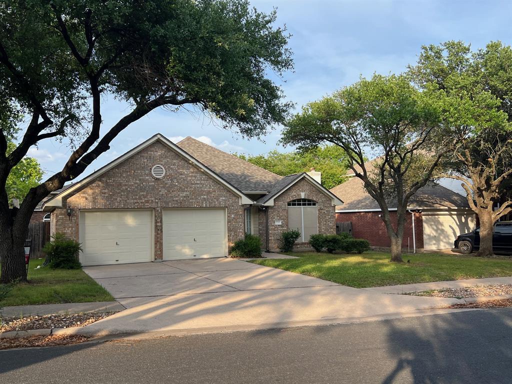
1728 Dapplegrey Ln
Austin, TX 78727
Today
Favorites
512-335-8686
-
Bedrooms
3
-
Bathrooms
2
-
Square Feet
1,768 sq ft
-
Available
Available Now
Highlights
- Soaking Tub
- 1-Story Property
- Central Heating and Cooling System
- Dogs and Cats Allowed
- West Facing Home
- Carpet
1728 Dapplegrey Ln

Favorites
About This Home
Available Now
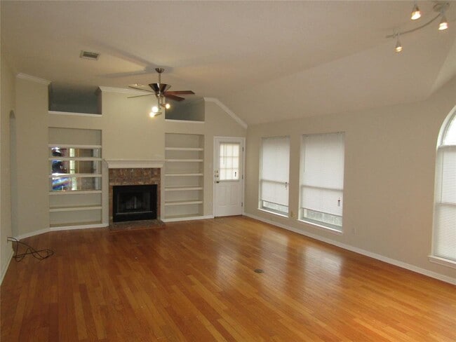
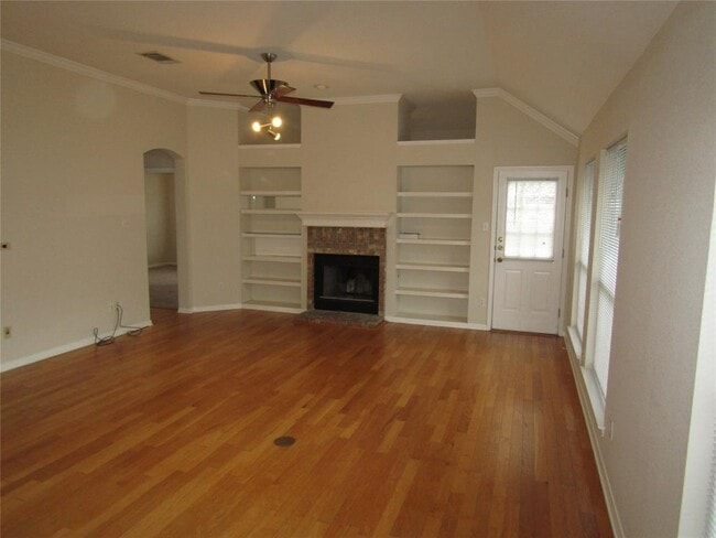
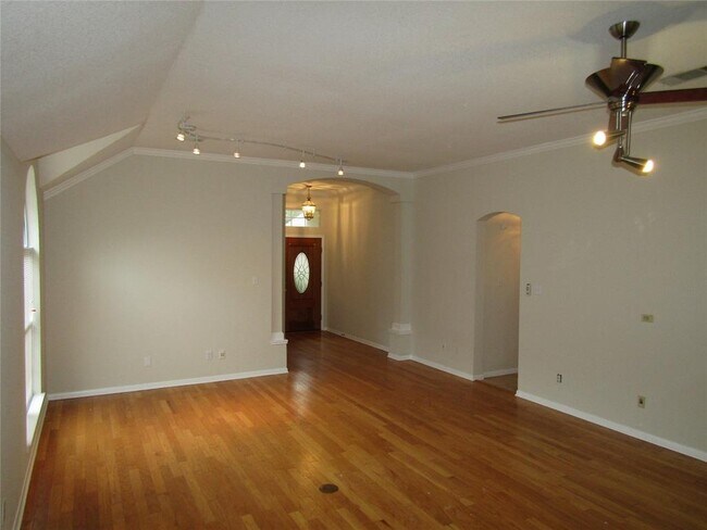
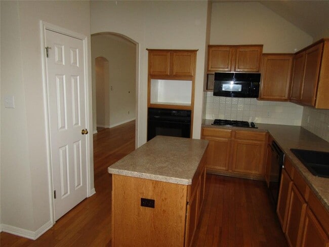
Beautiful three bedroom two bath home, with well maintained lawn, two car garage, washer and dryer and back lawn. Master suite features walk in closet, garden tub, separate shower and water closet, long vanity, and bonus room. All properties in our portfolio are required to participate in a mandatory Resident Benefits Package (RBP), designed to provide savings and convenient professional services that make maintaining your home hassle-free. The cost of this program is available for $43/month. Liability Insurance is also required for an additional $11.95 (this can be removed by providing your own insurance evidence if the required standards are met).
1728 Dapplegrey Ln is a house located in Travis County and the 78727 ZIP Code. This area is served by the Pflugerville Independent attendance zone.
* Price shown is base rent and may not include non-optional fees and utilities. Price, availability, fees, and any applicable rent special are subject to change without notice.
* Square footage definitions vary. Displayed square footage is approximate.
Home Details
Home Type
Single Family Detached Home
Year Built
Built in 1995
Bedrooms and Bathrooms
3 Main Level Bedrooms
Soaking Tub
2 Full Bathrooms
Flooring
Carpet
Laminate
Home Security
Carbon Monoxide Detectors
Fire and Smoke Detector
Interior Spaces
Living Room with Fireplace
1-Story Property
1,768 Sq Ft Home
Kitchen
Built-In Oven
Gas Cooktop
Dishwasher
Disposal
Listing and Financial Details
Security Deposit $2,200
12 Month Lease Term
$75 Application Fee
Assessor Parcel Number 02621811160000
Tax Block K
Tenant pays for all utilities
Lot Details
6,447 Sq Ft Lot
West Facing Home
Parking
2 Car Garage
Front Facing Garage
Driveway
Schools
Parmer Lane Elementary School
Westview Middle School
John B Connally High School
Utilities
Central Heating and Cooling System
Heating System Uses Natural Gas
Community Details
Overview
Property has a Home Owners Association
Property managed by NRPM
Scofield Ph 06 Sec 04 Subdivision
Pet Policy
Dogs and Cats Allowed
Breed Restrictions
Limit on the number of pets
Pet Size Limit
Medium pets allowed
Pet Deposit $300
Fees and Policies
The fees below are based on community-supplied data and may exclude additional fees and utilities.
- Dogs Allowed
-
Fees not specified
- Cats Allowed
-
Fees not specified
Contact
- Listed by Robbie Sparks | Neighborhood Realty&Prop Mgmt
- Phone Number
- Contact
-
Source
 Austin Board of REALTORS®
The information included in this listing is provided exclusively for consumers’ personal, non-commercial use and may not be used for any purpose other than to identify prospective properties consumers may be interested in purchasing. The information on each listing is furnished by the owner and deemed reliable to the best of his/her knowledge, but should be verified by the purchaser. ABoR, ACTRIS and Estately assume no responsibility for typographical errors, misprints or misinformation. This property listing is offered without respect to any protected classes in accordance with the law. Copyright © 2025.
Location
Get Directions
Amenities
- Dishwasher
- Disposal
- Refrigerator
- Carpet
Scofield Farms is a peaceful suburban community located about 12 miles northeast of Downtown Austin and about 11 miles north of the University of Texas at Austin. This neighborhood is nicely contained with cozy residential streets, a large shopping area, and the Scofield Farms Neighborhood Park extending through the center of the neighborhood. The park is separated from the Wells Creek Greenbelt by Metric Boulevard, providing ample hiking trails for residents to enjoy.
Parmer Lane is lined with a variety of shops and restaurants, and additional shopping and dining options are available along I-35, directly east of Scofield Farms. Residents are close to the Walnut Creek Metropolitan Park, a large park with a leash-free hiking trail, picnic areas, a municipal pool, and a BMX track. Other nearby locations include St. David’s North Austin Medical Center, the Domain shopping mall, and Wells Branch Disc Golf Course.
Learn more about living in Scofield Farms
Education
| Colleges & Universities | Distance | ||
|---|---|---|---|
| Colleges & Universities | Distance | ||
| Drive: | 5 min | 1.8 mi | |
| Drive: | 10 min | 5.6 mi | |
| Drive: | 15 min | 10.7 mi | |
| Drive: | 23 min | 14.2 mi |
1728 Dapplegrey Ln is within 5 minutes or 1.8 miles from Austin C.C., Northridge Campus. It is also near The Art Institute of Austin and University of Texas at Austin.
Schools


Public Elementary School
Grades PK-5
456 Students
Attendance Zone
Public Middle School
Grades 6-8
718 Students
Attendance Zone
Public High School
Grades 9-12
1,663 Students
Attendance Zone
Private Elementary, Middle & High School
Grades PK-12
651 Students
Nearby
Private Elementary School
Grades PK-6
9 Students
Nearby
Private High School
Grades 10-12
Nearby
School data provided by
 The GreatSchools Rating helps parents compare schools within a state based on a variety of school quality indicators and provides a helpful picture of how effectively each school serves all of its students. Ratings are on a scale of 1 (below average) to 10 (above average) and can include test scores, college readiness, academic progress, advanced courses, equity, discipline and attendance data. We also advise parents to visit schools, consider other information on school performance and programs, and consider family needs as part of the school selection process.
View GreatSchools Rating Methodology
Data provided by GreatSchools.org © 2025. All rights reserved.
View GreatSchools Rating Methodology
Data provided by GreatSchools.org © 2025. All rights reserved.
Transportation options available in Austin include Kramer Station, located 3.1 miles from 1728 Dapplegrey Ln. 1728 Dapplegrey Ln is near Austin-Bergstrom International, located 22.2 miles or 34 minutes away.
| Transit / Subway | Distance | ||
|---|---|---|---|
| Transit / Subway | Distance | ||
| Drive: | 7 min | 3.1 mi | |
| Drive: | 6 min | 3.2 mi | |
| Drive: | 8 min | 3.4 mi | |
| Drive: | 11 min | 6.4 mi | |
| Drive: | 12 min | 7.6 mi |
| Commuter Rail | Distance | ||
|---|---|---|---|
| Commuter Rail | Distance | ||
|
|
Drive: | 20 min | 13.3 mi |
|
|
Drive: | 35 min | 27.2 mi |
| Airports | Distance | ||
|---|---|---|---|
| Airports | Distance | ||
|
Austin-Bergstrom International
|
Drive: | 34 min | 22.2 mi |
Time and distance from 1728 Dapplegrey Ln.
| Shopping Centers | Distance | ||
|---|---|---|---|
| Shopping Centers | Distance | ||
| Walk: | 9 min | 0.5 mi | |
| Walk: | 9 min | 0.5 mi | |
| Walk: | 15 min | 0.8 mi |
1728 Dapplegrey Ln has 3 shopping centers within 0.8 mile, which is about a 15-minute walk. The miles and minutes will be for the farthest away property.
| Parks and Recreation | Distance | ||
|---|---|---|---|
| Parks and Recreation | Distance | ||
|
Walnut Creek Park
|
Drive: | 3 min | 1.4 mi |
|
Balcones District Park
|
Drive: | 6 min | 3.1 mi |
|
Copperfield Nature Trail and Park
|
Drive: | 6 min | 3.5 mi |
|
The Stephen F. Austin Planetarium
|
Drive: | 8 min | 4.4 mi |
|
Jourdan-Bachman Pioneer Farms
|
Drive: | 9 min | 5.0 mi |
1728 Dapplegrey Ln has 5 parks within 5.0 miles, including Walnut Creek Park, Balcones District Park, and Copperfield Nature Trail and Park.
| Hospitals | Distance | ||
|---|---|---|---|
| Hospitals | Distance | ||
| Drive: | 5 min | 2.4 mi | |
| Drive: | 9 min | 5.1 mi | |
| Drive: | 11 min | 6.5 mi |
1728 Dapplegrey Ln has 3 hospitals within 6.5 miles, the nearest is North Austin Medical Center which is 2.4 miles away and a 5 minute drive.
| Military Bases | Distance | ||
|---|---|---|---|
| Military Bases | Distance | ||
| Drive: | 79 min | 63.4 mi | |
| Drive: | 94 min | 77.4 mi |
1728 Dapplegrey Ln is 63.4 miles from Fort Hood, and is convenient to other military bases, including Randolph Air Force Base.
You May Also Like
Similar Rentals Nearby


What Are Walk Score®, Transit Score®, and Bike Score® Ratings?
Walk Score® measures the walkability of any address. Transit Score® measures access to public transit. Bike Score® measures the bikeability of any address.
What is a Sound Score Rating?
A Sound Score Rating aggregates noise caused by vehicle traffic, airplane traffic and local sources

1728 Dapplegrey Ln
Austin, TX 78727