

$2,800
/ Month
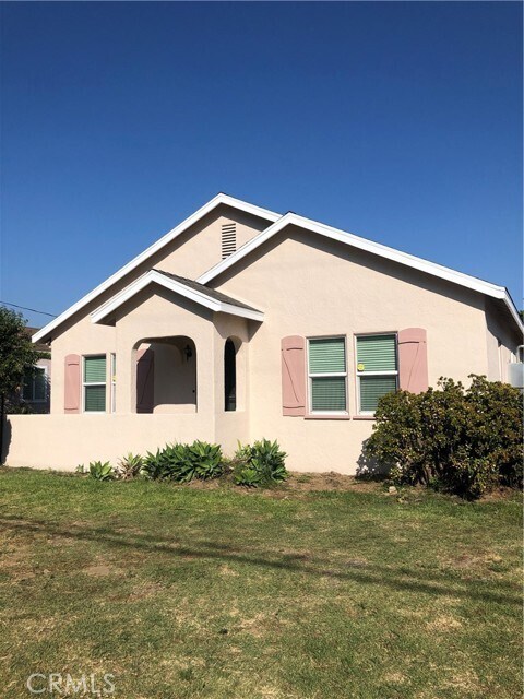
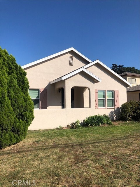
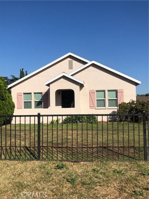
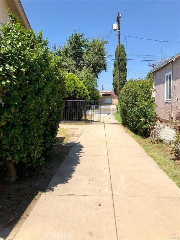
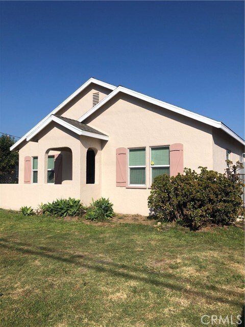
1702 S Gladys Ave
San Gabriel, CA 91776
2 Weeks Ago
|
Edit
Favorites
1702 S Gladys Ave

Favorites
Check Back Soon for Upcoming Availability
| Beds | Baths | Average SF |
|---|---|---|
| 2 Bedrooms 2 Bedrooms 2 Br | 2 Baths 2 Baths 2 Ba | 1,136 SF |
Fees and Policies
The fees below are based on community-supplied data and may exclude additional fees and utilities.
- Parking
-
Garage--
About This Property
Great Location!! Well maintained home for rent located in a prime area of Valley Blvd and San Gabriel Blvd. This spacious house offers large living room & dining room, 2 spacious bedrooms, 2 bathrooms, and a kitchen with breakfast nook. Inside bright and airy. Nice wood floor throughout. Freshly cleaned up. Appliances include stove, refrigerator, washer & dryer. Central AC & Heater. Huge backyard for entertainment or outdoor activities. Very convenient location, go out on Valley Blvd. and enjoy all kinds of restaurant of your choice. Close to shopping plaza and supermarkets. Easy access to bus stops and 10 Freeway.
1702 S Gladys Ave is a house located in Los Angeles County and the 91776 ZIP Code. This area is served by the Rosemead Elementary attendance zone.
House Features
Washer/Dryer
Air Conditioning
Refrigerator
Heating
- Washer/Dryer
- Air Conditioning
- Heating
- Range
- Refrigerator
Location
Get Directions
Situated about ten miles northeast of Los Angeles, San Gabriel is a scenic suburb often regarded as the “Birthplace of the Los Angeles Region.” The city boasts a rich history dating back to the 1700s, when the Mission San Gabriel (known as the “Pride of the California Missions”) was founded.
San Gabriel’s historic roots are on display to this day, with the vibrant Mission District serving as the city’s hub of culture, art, and history. City Hall, the San Gabriel Mission Playhouse, and numerous well-maintained Spanish Colonial Revival style buildings are the cornerstones of the District. A host of diverse eateries, cafes, offices, shops, and museums—including the famed San Gabriel Mission—are also found in this vibrant downtown area.
Area residents enjoy a bevy of outdoor activities at Vincent Lugo Park, Smith Park, and San Gabriel Country Club.
Learn more about living in San Gabriel
Amenities
- Washer/Dryer
- Air Conditioning
- Heating
- Range
- Refrigerator
Education
| Colleges & Universities | Distance | ||
|---|---|---|---|
| Colleges & Universities | Distance | ||
| Drive: | 10 min | 5.5 mi | |
| Drive: | 14 min | 5.9 mi | |
| Drive: | 11 min | 6.1 mi | |
| Drive: | 14 min | 6.6 mi |
1702 S Gladys Ave is within 10 minutes or 5.5 miles from Cal State Los Angeles. It is also near Caltech and Pasadena City College.
Schools


Public Elementary School
Grades K-6
596 Students
Attendance Zone
Public Middle School
Grades 7-8
517 Students
Attendance Zone
Public High School
Grades 9-12
1,679 Students
Attendance Zone
Private Elementary, Middle & High School
Grades K-12
Nearby
Private Elementary & Middle School
Grades PK-8
150 Students
Nearby
Private High School
Grades 10-12
Nearby
School data provided by
 The GreatSchools Rating helps parents compare schools within a state based on a variety of school quality indicators and provides a helpful picture of how effectively each school serves all of its students. Ratings are on a scale of 1 (below average) to 10 (above average) and can include test scores, college readiness, academic progress, advanced courses, equity, discipline and attendance data. We also advise parents to visit schools, consider other information on school performance and programs, and consider family needs as part of the school selection process.
View GreatSchools Rating Methodology
Data provided by GreatSchools.org © 2026. All rights reserved.
View GreatSchools Rating Methodology
Data provided by GreatSchools.org © 2026. All rights reserved.
Transportation options available in San Gabriel include South Pasadena, located 6.1 miles from 1702 S Gladys Ave. 1702 S Gladys Ave is near Bob Hope, located 24.1 miles or 32 minutes away, and Long Beach (Daugherty Field), located 24.5 miles or 35 minutes away.
| Transit / Subway | Distance | ||
|---|---|---|---|
| Transit / Subway | Distance | ||
|
|
Drive: | 14 min | 6.1 mi |
|
|
Drive: | 13 min | 6.7 mi |
|
|
Drive: | 11 min | 6.8 mi |
|
|
Drive: | 14 min | 6.8 mi |
|
|
Drive: | 12 min | 8.3 mi |
| Commuter Rail | Distance | ||
|---|---|---|---|
| Commuter Rail | Distance | ||
|
|
Drive: | 8 min | 4.4 mi |
|
|
Drive: | 14 min | 6.7 mi |
|
|
Drive: | 14 min | 9.4 mi |
|
|
Drive: | 18 min | 12.1 mi |
| Drive: | 16 min | 13.4 mi |
| Airports | Distance | ||
|---|---|---|---|
| Airports | Distance | ||
|
Bob Hope
|
Drive: | 32 min | 24.1 mi |
|
Long Beach (Daugherty Field)
|
Drive: | 35 min | 24.5 mi |
Time and distance from 1702 S Gladys Ave.
| Shopping Centers | Distance | ||
|---|---|---|---|
| Shopping Centers | Distance | ||
| Walk: | 4 min | 0.2 mi | |
| Walk: | 7 min | 0.4 mi | |
| Walk: | 8 min | 0.4 mi |
1702 S Gladys Ave has 3 shopping centers within 0.4 mile, which is about a 8-minute walk. The miles and minutes will be for the farthest away property.
| Parks and Recreation | Distance | ||
|---|---|---|---|
| Parks and Recreation | Distance | ||
|
Whittier Narrows Recreation Area
|
Drive: | 10 min | 3.8 mi |
|
Huntington Botanical Gardens
|
Drive: | 13 min | 4.8 mi |
|
Whittier Narrows Nature Center
|
Drive: | 11 min | 6.3 mi |
|
Los Angeles County Arboretum
|
Drive: | 13 min | 6.4 mi |
|
Chilao Visitor Center
|
Drive: | 15 min | 8.1 mi |
1702 S Gladys Ave has 5 parks within 8.1 miles, including Whittier Narrows Recreation Area, Huntington Botanical Gardens, and Whittier Narrows Nature Center.
| Hospitals | Distance | ||
|---|---|---|---|
| Hospitals | Distance | ||
| Drive: | 3 min | 1.6 mi | |
| Drive: | 5 min | 2.3 mi | |
| Drive: | 5 min | 2.9 mi |
1702 S Gladys Ave has 3 hospitals within 2.9 miles, the nearest is BHC Alhambra Hospital which is 1.6 miles away and a 3 minute drive.
| Military Bases | Distance | ||
|---|---|---|---|
| Military Bases | Distance | ||
| Drive: | 40 min | 26.3 mi | |
| Drive: | 35 min | 27.1 mi |
1702 S Gladys Ave is 26.3 miles from Los Alamitos Army Airfield, and is convenient to other military bases, including Los Angeles Air Force Base.
You May Also Like
Similar Rentals Nearby


What Are Walk Score®, Transit Score®, and Bike Score® Ratings?
Walk Score® measures the walkability of any address. Transit Score® measures access to public transit. Bike Score® measures the bikeability of any address.
What is a Sound Score Rating?
A Sound Score Rating aggregates noise caused by vehicle traffic, airplane traffic and local sources
1702 S Gladys Ave
San Gabriel, CA 91776