
$5,600
Total Monthly Price
17 Shirley St
Quincy, MA 02169
Today
|
Edit
Favorites
508-404-8705
-
Bedrooms
6
-
Bathrooms
5
-
Square Feet
3,395 sq ft
-
Available
Available Now
Highlights
- 2 Fireplaces
- No Cooling
- Heating System Uses Natural Gas
17 Shirley St

Favorites
About This Home
$5,600 deposit,
Available Now
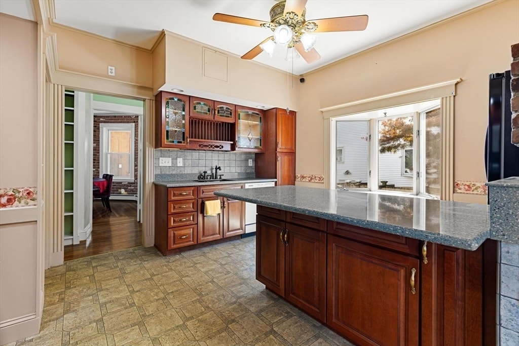
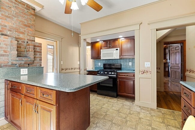
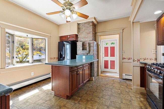
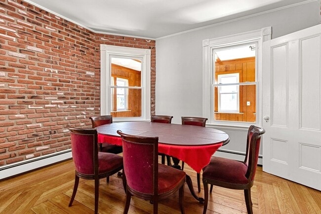
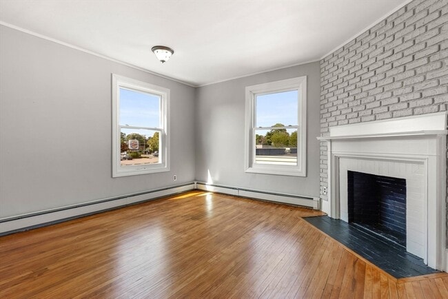
Available NOW. Beautifully maintained 6-bedroom,5-bathroom Victorian home blending historic charm with modern updates. The four-floor layout includes an enclosed porch,a double living room with fireplaces,four bedrooms on the second floor,two ensuite bedrooms on the third,and a renovated lower-level flex space. Conveniently located near transit and amenities. First month's rent and security deposit required; Tenants are responsible for all utilities and water. No smoking,no pets. MLS# 73470837
17 Shirley St is a house located in Norfolk County and the 02169 ZIP Code. This area is served by the Quincy attendance zone.
* Price shown is total price based on community-supplied monthly required fees. Excludes user-selected optional fees and variable or usage-based fees and required charges due at or prior to move-in or at move-out. Price, availability, fees, and any applicable rent special are subject to change without notice.
* Square footage definitions vary. Displayed square footage is approximate.
Home Details
Home Type
Single Family Detached Home
Bedrooms and Bathrooms
5 Full Bathrooms
6 Bedrooms
Home Design
Entry on the 1st floor
Interior Spaces
2 Fireplaces
3,395 Sq Ft Home
Kitchen
Range
Microwave
Dishwasher
Disposal
Laundry
Dryer
Laundry in unit
Washer
Listing and Financial Details
Security Deposit $5,600
12 Month Lease Term
Assessor Parcel Number 184014
Rent includes sewer, trash collection, snow removal, extra storage, parking
Lot Details
5,660 Sq Ft Lot
Parking
4 Open Parking Spaces
4 Car Parking Spaces
Utilities
No Cooling
Heating System Uses Natural Gas
Community Details
Overview
No Home Owners Association
Pet Policy
No Pets Allowed
Fees and Policies
The fees below are based on community-supplied data and may exclude additional fees and utilities.
-
One-Time Basics
-
Due at Move-In
-
Security Deposit - RefundableCharged per unit.$5,600
-
-
Due at Move-In
Property Fee Disclaimer: Based on community-supplied data and independent market research. Subject to change without notice. May exclude fees for mandatory or optional services and usage-based utilities.
Contact
- Listed by Jing Chen | Peace of Mind Realty
- Phone Number
-
Source
 MLS Property Information Network
The property listing data and information set forth herein were provided to MLS Property Information Network, Inc. from third party sources, including sellers, lessors and public records, and were compiled by MLS Property Information Network, Inc. The property listing data and information are for the personal, non-commercial use of consumers having a good faith interest in purchasing or leasing listed properties of the type displayed to them and may not be used for any purpose other than to identify prospective properties which such consumers may have a good faith interest in purchasing or leasing. MLS Property Information Network, Inc. and its subscribers disclaim any and all representations and warranties as to the accuracy of the property listing data and information set forth herein. All properties are subject to prior sale, change or withdrawal. Copyright © 2026 MLS Property Information Network, Inc. All rights reserved.
Location
Get Directions
Amenities
- Dishwasher
- Disposal
- Microwave
- Range
- Refrigerator
The Blue Hills Reservation takes up much of West Quincy. This 6,000-acre state park is one of the Boston area’s largest parcels of undeveloped land, culminating in its highest point, Great Blue Hill. Enjoy panoramic views from this vantage point and visit the historic Blue Hill Meteorological Observatory, founded by meteorologist and MIT grad, Abbott Lawrence Rotch in 1885. It is still active and is open to the public on weekends.
The north end of West Quincy is a wooded, attractive neighborhood with ample sidewalks that residents use for evening strolls or walking their dogs. The neighborhood provides ample mass transit and the Quincy Center subway station is only a mile or so to the east, making commuting throughout the Boston area a breeze.
While West Quincy is largely residential, you’ll find several shops and restaurants along Willard Street, as well as a few local favorites along Adams Street. Be sure to visit Brick & Beam, a rustic tavern, and Dairy Freeze for ice cream.
Learn more about living in West Quincy
Education
| Colleges & Universities | Distance | ||
|---|---|---|---|
| Colleges & Universities | Distance | ||
| Drive: | 13 min | 5.4 mi | |
| Drive: | 10 min | 5.6 mi | |
| Drive: | 14 min | 8.3 mi | |
| Drive: | 17 min | 8.8 mi |
17 Shirley St is within 13 minutes or 5.4 miles from Curry College. It is also near UMass Boston and Wentworth Inst. of Technology.
Schools


Public Elementary School
Grades K-5
340 Students
Attendance Zone
Public Elementary School
Grades K-5
584 Students
Nearby
Public Middle School
Grades 6-8
647 Students
Attendance Zone
Public High School
Grades 9-12
1,476 Students
Attendance Zone
Private Elementary & Middle School
Grades PK-8
125 Students
Nearby
Private Middle & High School
Grades 6-12
59 Students
Nearby
School data provided by
 The GreatSchools Rating helps parents compare schools within a state based on a variety of school quality indicators and provides a helpful picture of how effectively each school serves all of its students. Ratings are on a scale of 1 (below average) to 10 (above average) and can include test scores, college readiness, academic progress, advanced courses, equity, discipline and attendance data. We also advise parents to visit schools, consider other information on school performance and programs, and consider family needs as part of the school selection process.
View GreatSchools Rating Methodology
Data provided by GreatSchools.org © 2026. All rights reserved.
View GreatSchools Rating Methodology
Data provided by GreatSchools.org © 2026. All rights reserved.
Transportation options available in Quincy include Wollaston Station, located 1.2 miles from 17 Shirley St. 17 Shirley St is near General Edward Lawrence Logan International, located 11.0 miles or 18 minutes away.
| Transit / Subway | Distance | ||
|---|---|---|---|
| Transit / Subway | Distance | ||
|
|
Drive: | 3 min | 1.2 mi |
|
|
Drive: | 5 min | 2.4 mi |
|
|
Drive: | 5 min | 2.4 mi |
|
|
Drive: | 6 min | 2.7 mi |
|
|
Drive: | 6 min | 2.8 mi |
| Commuter Rail | Distance | ||
|---|---|---|---|
| Commuter Rail | Distance | ||
|
|
Drive: | 4 min | 1.8 mi |
|
|
Drive: | 7 min | 3.6 mi |
| Drive: | 8 min | 4.2 mi | |
| Drive: | 9 min | 4.2 mi | |
|
|
Drive: | 8 min | 4.7 mi |
| Airports | Distance | ||
|---|---|---|---|
| Airports | Distance | ||
|
General Edward Lawrence Logan International
|
Drive: | 18 min | 11.0 mi |
Time and distance from 17 Shirley St.
| Shopping Centers | Distance | ||
|---|---|---|---|
| Shopping Centers | Distance | ||
| Walk: | 7 min | 0.4 mi | |
| Drive: | 3 min | 1.7 mi | |
| Drive: | 6 min | 2.0 mi |
17 Shirley St has 3 shopping centers within 2.0 miles, which is about a 6-minute drive. The miles and minutes will be for the farthest away property.
| Parks and Recreation | Distance | ||
|---|---|---|---|
| Parks and Recreation | Distance | ||
|
Adams National Historical Park
|
Drive: | 3 min | 1.2 mi |
|
Squantum Point Park
|
Drive: | 10 min | 4.1 mi |
|
Mass Audubon's Boston Nature Center and Wildlife Sanctuary
|
Drive: | 10 min | 4.8 mi |
|
Franklin Park Zoo
|
Drive: | 10 min | 5.5 mi |
|
Dorchester Shores Reservation
|
Drive: | 9 min | 5.6 mi |
17 Shirley St has 5 parks within 5.6 miles, including Adams National Historical Park, Squantum Point Park, and Mass Audubon's Boston Nature Center and Wildlife Sanctuary.
| Hospitals | Distance | ||
|---|---|---|---|
| Hospitals | Distance | ||
| Drive: | 6 min | 2.8 mi | |
| Drive: | 5 min | 2.9 mi | |
| Drive: | 11 min | 7.1 mi |
17 Shirley St has 3 hospitals within 7.1 miles, the nearest is Beth Israel Deaconess Hospital - Milton which is 2.8 miles away and a 6 minute drive.
You May Also Like
Similar Rentals Nearby


What Are Walk Score®, Transit Score®, and Bike Score® Ratings?
Walk Score® measures the walkability of any address. Transit Score® measures access to public transit. Bike Score® measures the bikeability of any address.
What is a Sound Score Rating?
A Sound Score Rating aggregates noise caused by vehicle traffic, airplane traffic and local sources

17 Shirley St
Quincy, MA 02169