

$1,900
/ Month
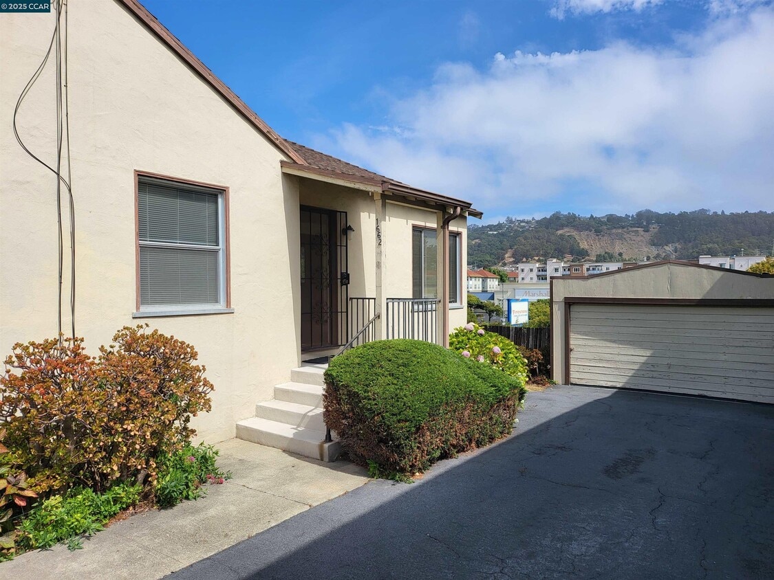
1662 San Benito St
Richmond, CA 94804
Today
|
Edit
Favorites
510-758-5636
-
Bedrooms
1
-
Bathrooms
1
-
Square Feet
700 sq ft
-
Available
Available Now
Highlights
- Carpet
- Wall Furnace
- 1-Story Property
1662 San Benito St

Favorites
About This Home
Available Now
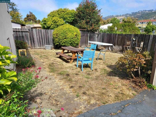
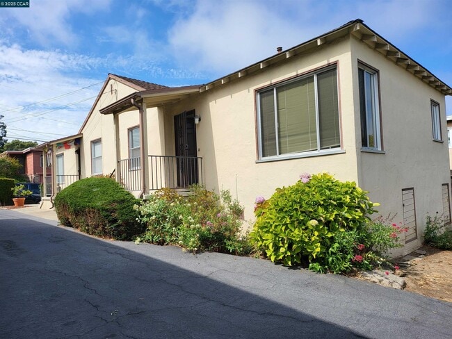
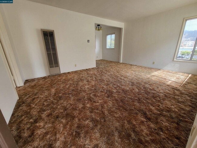
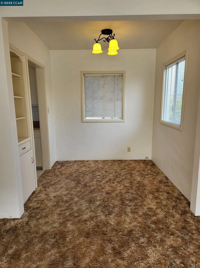
Welcome to this rear cozy one-bedroom,one-bathroom unit located on the border of Richmond and El Cerrito,CA. The unit has wall-to-wall carpets,a gas stove,refrigerator (as-is) with the original charm of built-in cabinets/storage throughout. The unit has an additional storage area off the kitchen that has washer/dryer hookups for a stackable unit only (volted for 110V only). The unit is conveniently located near public transportation,schools,and shops. The 80 Freeway to Oakland/ San Francisco and San Rafael is conveniently easy to access,tenant is responsible for all utilities,shared back yard and shared driveway with front unit,No Pets. $ 1,900 Rent / $ 1,900 Deposit / $ 3,800 Total Move-In Cost
1662 San Benito St is a townhome located in Contra Costa County and the 94804 ZIP Code. This area is served by the West Contra Costa Unified attendance zone.
* Price shown is base rent. Excludes user-selected optional fees and variable or usage-based fees and required charges due at or prior to move-in or at move-out. Price, availability, fees, and any applicable rent special are subject to change without notice.
* Square footage definitions vary. Displayed square footage is approximate.
Home Details
Home Type
Duplex
Year Built
Built in 1942
Bedrooms and Bathrooms
1 Full Bathroom
1 Bedroom
Home Design
Stucco
Interior Spaces
Carpet
1-Story Property
Kitchen
Gas Range
Laundry
No Washer or Dryer Hookups
Listing and Financial Details
Assessor Parcel Number 5082910182
Lot Details
5,000 Sq Ft Lot
Utilities
Wall Furnace
Community Details
Overview
No Home Owners Association
Richmond Subdivision
Contact
- Listed by Gene Smith | First Republic Real Estate
- Phone Number
- Contact
-
Source
 Contra Costa Association of REALTORS®
Copyright © 2025 Bay East, CCAR, bridgeMLS. Based on information from Bay East and Contra Costa Association of REALTORS® and bridgeMLS. All data, including all measurements and calculations of area, is obtained from various sources and has not been, and will not be, verified by broker or MLS. All information should be independently reviewed and verified for accuracy. If a floor plan is included, the floor plan is for illustrative purposes only, and the actual dimensions and layout of the home may differ from the floor plan. Buyer is urged to make a detailed inspection of the property, and if any aspect of a floor plan is critical to the buyer's decision to purchase, buyer must conduct their own measurements and inspection. Properties may or may not be listed by the office/agent presenting the information.
Location
Get Directions
Rent an apartment in the Richmond Annex and enjoy easy access to I-80, which takes you into San Francisco. Central Avenue leads to Point Isabel, a small peninsula in San Francisco Bay.
Just across the Richmond Annex's southern border sits Albany Hill Park. Hike to the top of Albany Hill, and take in a panoramic view of the Bay Area. More trails await at the Albany Mudflats State Marine Park, just west of I-580.
Explore Playland-Not-at-the-Beach at the northern end of the neighborhood. This local hangout, with a museum and community center, features games and events for all ages. San Pablo Avenue, the hotspot for local restaurants, features international cuisine for a wide range taste buds.
Learn more about living in Richmond Annex
Education
| Colleges & Universities | Distance | ||
|---|---|---|---|
| Colleges & Universities | Distance | ||
| Drive: | 12 min | 4.6 mi | |
| Drive: | 15 min | 5.4 mi | |
| Drive: | 10 min | 5.9 mi | |
| Drive: | 13 min | 8.6 mi |
1662 San Benito St is within 12 minutes or 4.6 miles from Berkeley City College. It is also near Contra Costa College and UC Berkeley.
Schools


Public Elementary School
Grades K-5
270 Students
Nearby
Public Elementary School
Grades K-6
503 Students
Attendance Zone
Public Middle School
Grades 7-8
681 Students
Attendance Zone
Public High School
Grades 9-12
1,522 Students
Attendance Zone
Private Elementary, Middle & High School
Grades PK-12
Nearby
Private Elementary, Middle & High School
Grades K-11
Nearby
Private Elementary & Middle School
Grades K-8
189 Students
Nearby
Private Middle & High School
Grades 6-12
141 Students
Nearby
School data provided by
 The GreatSchools Rating helps parents compare schools within a state based on a variety of school quality indicators and provides a helpful picture of how effectively each school serves all of its students. Ratings are on a scale of 1 (below average) to 10 (above average) and can include test scores, college readiness, academic progress, advanced courses, equity, discipline and attendance data. We also advise parents to visit schools, consider other information on school performance and programs, and consider family needs as part of the school selection process.
View GreatSchools Rating Methodology
Data provided by GreatSchools.org © 2025. All rights reserved.
View GreatSchools Rating Methodology
Data provided by GreatSchools.org © 2025. All rights reserved.
Transportation options available in Richmond include El Cerrito Plaza Station, located 1.3 miles from 1662 San Benito St. 1662 San Benito St is near Metro Oakland International, located 19.0 miles or 27 minutes away, and San Francisco International, located 26.6 miles or 40 minutes away.
| Transit / Subway | Distance | ||
|---|---|---|---|
| Transit / Subway | Distance | ||
|
|
Drive: | 3 min | 1.3 mi |
|
|
Drive: | 4 min | 1.7 mi |
|
|
Drive: | 4 min | 1.7 mi |
|
|
Drive: | 9 min | 3.6 mi |
|
|
Drive: | 7 min | 3.7 mi |
| Commuter Rail | Distance | ||
|---|---|---|---|
| Commuter Rail | Distance | ||
| Drive: | 8 min | 3.9 mi | |
|
|
Drive: | 8 min | 4.6 mi |
|
|
Drive: | 10 min | 6.4 mi |
|
|
Drive: | 16 min | 10.6 mi |
| Drive: | 21 min | 14.2 mi |
| Airports | Distance | ||
|---|---|---|---|
| Airports | Distance | ||
|
Metro Oakland International
|
Drive: | 27 min | 19.0 mi |
|
San Francisco International
|
Drive: | 40 min | 26.6 mi |
Time and distance from 1662 San Benito St.
| Shopping Centers | Distance | ||
|---|---|---|---|
| Shopping Centers | Distance | ||
| Walk: | 4 min | 0.2 mi | |
| Walk: | 4 min | 0.3 mi | |
| Walk: | 7 min | 0.4 mi |
1662 San Benito St has 3 shopping centers within 0.4 mile, which is about a 7-minute walk. The miles and minutes will be for the farthest away property.
| Parks and Recreation | Distance | ||
|---|---|---|---|
| Parks and Recreation | Distance | ||
|
Eddy Arboretum
|
Drive: | 5 min | 2.2 mi |
|
Point Isabel Regional Shoreline
|
Drive: | 7 min | 2.3 mi |
|
Blake Garden
|
Drive: | 6 min | 2.4 mi |
|
Marina Park & Green
|
Drive: | 8 min | 3.3 mi |
|
Shimada Friendship Park
|
Drive: | 9 min | 3.8 mi |
1662 San Benito St has 5 parks within 3.8 miles, including Blake Garden, Point Isabel Regional Shoreline, and Eddy Arboretum.
| Hospitals | Distance | ||
|---|---|---|---|
| Hospitals | Distance | ||
| Drive: | 15 min | 7.6 mi | |
| Drive: | 13 min | 8.5 mi | |
| Drive: | 13 min | 8.5 mi |
1662 San Benito St has 3 hospitals within 8.5 miles, the nearest is Alta Bates Summit Medical Center - Alta Bates Campus which is 7.6 miles away and a 15 minute drive.
| Military Bases | Distance | ||
|---|---|---|---|
| Military Bases | Distance | ||
| Drive: | 5 min | 1.9 mi | |
| Drive: | 9 min | 4.8 mi | |
| Drive: | 19 min | 9.7 mi |
1662 San Benito St has 3 military bases within 9.7 miles, the nearest is Military Reservation which is 1.9 miles away and a 5 minute drive.
You May Also Like
Similar Rentals Nearby


What Are Walk Score®, Transit Score®, and Bike Score® Ratings?
Walk Score® measures the walkability of any address. Transit Score® measures access to public transit. Bike Score® measures the bikeability of any address.
What is a Sound Score Rating?
A Sound Score Rating aggregates noise caused by vehicle traffic, airplane traffic and local sources
1662 San Benito St
Richmond, CA 94804