
Presidential Towers
555 W Madison St,
Chicago, IL 60661
$1,655 - $6,728
Studio - 2 Beds
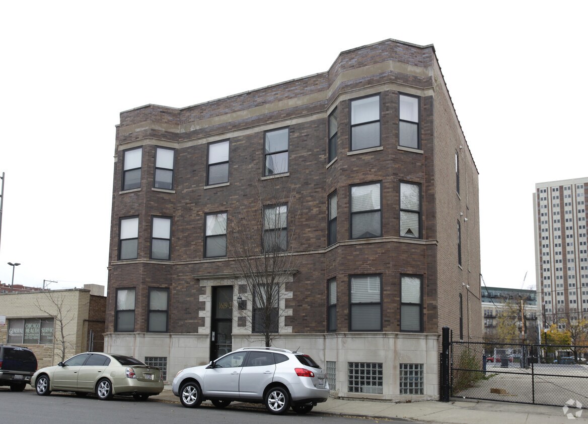

At 1619-1621 W Warren Blvd in Chicago, you've discovered your new home. The 60612 location is an ideal place to move. The leasing staff is waiting to show you all that this community has to offer. Come for a visit to view the available floorplans. Contact us or drop by the leasing office to check the current floorplan availability and make your move to 1619-1621 W Warren Blvd.
1619-1621 W Warren Blvd is an apartment community located in Cook County and the 60612 ZIP Code. This area is served by the Chicago Public Schools attendance zone.
Dotted with parks and adjacent to Interstate 290, Near West Side is the perfect neighborhood for any commuter looking for refreshing, wide-open space. Interstate 290 runs through the south side of the neighborhood, which lies roughly two miles away from Chicago's city center. Public transportation options include the Blue Line rapid transit system and several bus routes, which make it easy to get around the area. Rentals, which incorporate both modern and historic properties, cost a little more than the Chicago city average because of the neighborhood's proximity to downtown.
If you’re looking for what to do in Near Westside, look no further! United Center, home to the Chicago Bulls and the Chicago Blackhawks, sits on the neighborhood's east side. In addition to featuring basketball and hockey games, this versatile venue regularly hosts concerts and other entertainment events, making it a social hub for locals and visitors alike.
Learn more about living in Near West SideCompare neighborhood and city base rent averages by bedroom.
| Near West Side | Chicago, IL | |
|---|---|---|
| Studio | - | $1,654 |
| 1 Bedroom | $1,920 | $2,056 |
| 2 Bedrooms | $2,352 | $2,594 |
| 3 Bedrooms | $2,131 | $3,107 |
| Colleges & Universities | Distance | ||
|---|---|---|---|
| Colleges & Universities | Distance | ||
| Walk: | 11 min | 0.6 mi | |
| Walk: | 13 min | 0.7 mi | |
| Drive: | 3 min | 1.4 mi | |
| Drive: | 4 min | 1.8 mi |


Transportation options available in Chicago include Ashland Station (Green, Pink Lines), located 0.3 mile from 1619-1621 W Warren Blvd. 1619-1621 W Warren Blvd is near Chicago Midway International, located 9.2 miles or 16 minutes away, and Chicago O'Hare International, located 17.0 miles or 26 minutes away.
| Transit / Subway | Distance | ||
|---|---|---|---|
| Transit / Subway | Distance | ||
|
|
Walk: | 5 min | 0.3 mi |
|
|
Walk: | 12 min | 0.7 mi |
|
|
Walk: | 13 min | 0.7 mi |
|
|
Walk: | 16 min | 0.9 mi |
|
|
Drive: | 5 min | 2.6 mi |
| Commuter Rail | Distance | ||
|---|---|---|---|
| Commuter Rail | Distance | ||
|
|
Drive: | 2 min | 1.4 mi |
|
|
Drive: | 4 min | 1.7 mi |
|
|
Drive: | 4 min | 1.8 mi |
|
|
Drive: | 5 min | 2.4 mi |
|
|
Drive: | 6 min | 2.7 mi |
| Airports | Distance | ||
|---|---|---|---|
| Airports | Distance | ||
|
Chicago Midway International
|
Drive: | 16 min | 9.2 mi |
|
Chicago O'Hare International
|
Drive: | 26 min | 17.0 mi |
Scores provided by
Traffic
-Airport
-Businesses
-Scores provided by
HowLoud What is a Sound Score Rating? A Sound Score Rating aggregates noise caused by vehicle traffic, airplane traffic and local sources. How It WorksTime and distance from 1619-1621 W Warren Blvd.
| Shopping Centers | Distance | ||
|---|---|---|---|
| Shopping Centers | Distance | ||
| Walk: | 17 min | 0.9 mi | |
| Walk: | 18 min | 1.0 mi |
| Parks and Recreation | Distance | ||
|---|---|---|---|
| Parks and Recreation | Distance | ||
|
Alliance for the Great Lakes
|
Drive: | 5 min | 2.1 mi |
|
Openlands
|
Drive: | 5 min | 2.1 mi |
|
Millennium Park
|
Drive: | 5 min | 2.3 mi |
|
Douglas Park and Community Center
|
Drive: | 4 min | 2.4 mi |
|
Humboldt Park
|
Drive: | 6 min | 3.2 mi |
| Hospitals | Distance | ||
|---|---|---|---|
| Hospitals | Distance | ||
| Walk: | 11 min | 0.6 mi | |
| Walk: | 14 min | 0.8 mi | |
| Drive: | 2 min | 1.2 mi |
| Military Bases | Distance | ||
|---|---|---|---|
| Military Bases | Distance | ||
| Drive: | 34 min | 24.6 mi | |
| Drive: | 40 min | 27.9 mi | |
| Drive: | 50 min | 33.0 mi |
What Are Walk Score®, Transit Score®, and Bike Score® Ratings?
Walk Score® measures the walkability of any address. Transit Score® measures access to public transit. Bike Score® measures the bikeability of any address.
What is a Sound Score Rating?
A Sound Score Rating aggregates noise caused by vehicle traffic, airplane traffic and local sources.
1619-1621 W Warren Blvd
Chicago, IL 60612


