

$6,500 / Month
16 Pinevale Ave
Wellesley, MA 02482
Today
Favorites
781-910-1238
-
Bedrooms
4
-
Bathrooms
3.5
-
Square Feet
3,128 sq ft
-
Available
Available Now
Highlights
- Landscaped Professionally
- Property is near public transit
- Radiant Floor
- Cathedral Ceiling
- Wood Flooring
- Solid Surface Countertops
16 Pinevale Ave

Favorites
About This Home
$6,700 deposit,
Available Now
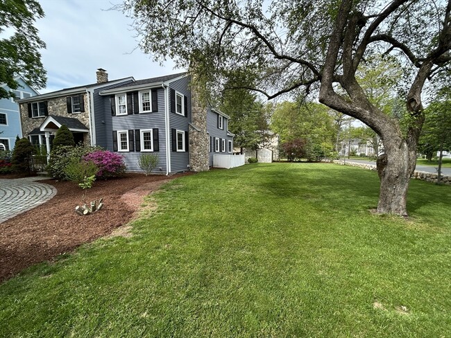
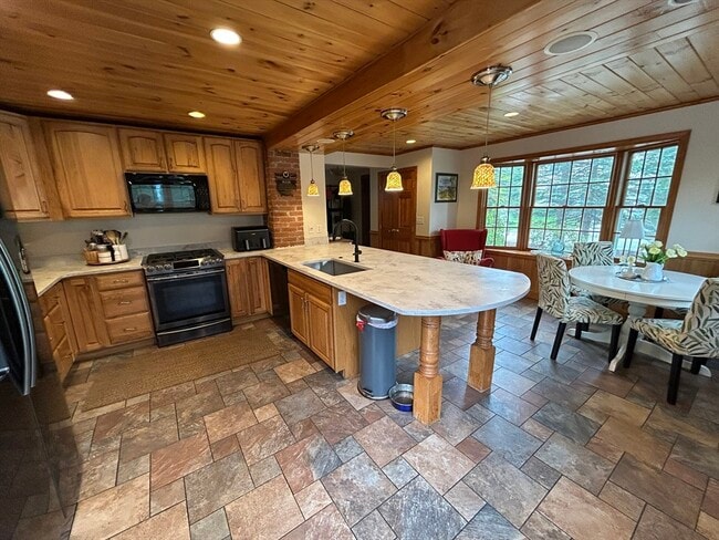
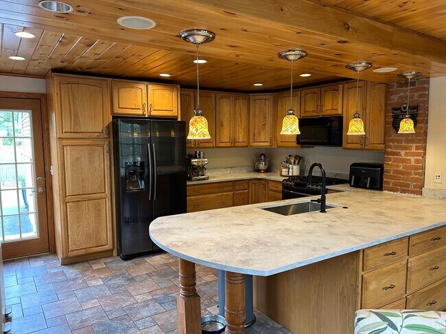
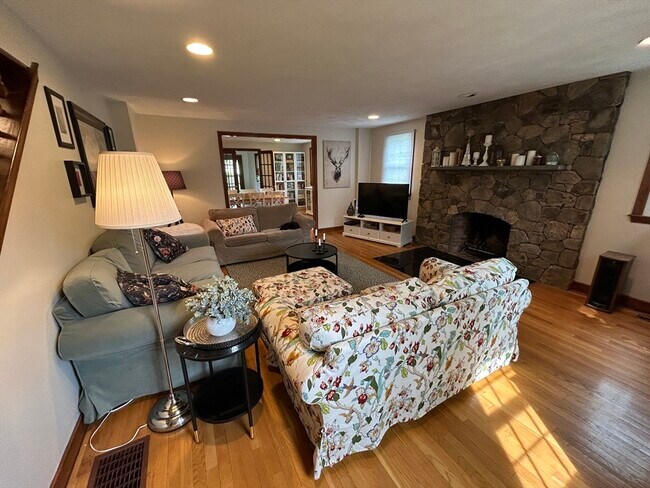
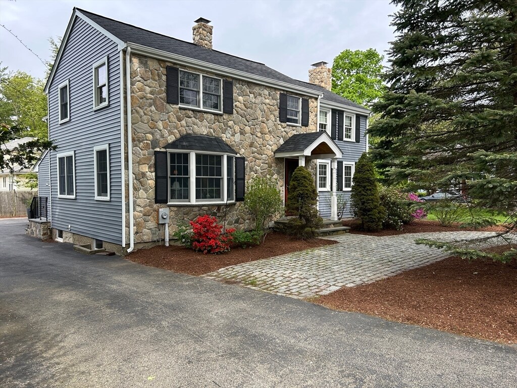
Beautifully Stone front Colonial renovated,expanded inside and out,4 bedroom rental on quiet ended way street. Large eat-in kitchen w/bow window,new white granite & breakfast bar. The freshly painted inviting living/dining room has a handsome stone fireplace is warm and inviting. Enjoy the all the season from lovely 4 season sunroom with access to the stone patio & yard with handsome stonewall. Second floor has 4 generous bedrooms,including a fantastic master suite w/a cathedral ceiling,skylight,a wall of windows,private bath & office nook. 3 bedrooms and full bath plus laundry room completes the 2nd floor. A terrific lower level w/playroom,a kitchenette,full bath and a second set of washer & dryer creating a great guest space complete with a walk-out door to the exterior. Hardwood floors throughout,AC,2 car garage,plenty of storage. Enjoy the brand new Hardy School in September 2025! MLS# 73374520
16 Pinevale Ave is a house located in Norfolk County and the 02482 ZIP Code. This area is served by the Wellesley attendance zone.
* Price shown is base rent and may not include non-optional fees and utilities.
Price, availability, fees, and any applicable rent special are subject to change without notice.
* Square footage definitions vary. Displayed square footage is approximate.
Home Details
Home Type
Single Family Detached Home
Year Built
Built in 1930
Accessible Home Design
Entry on the 1st floor
Basement
Exterior Basement Entry
Bedrooms and Bathrooms
Primary bedroom located on second floor
Separate Shower
3.5 Bathrooms
4 Bedrooms
Flooring
Radiant Floor
Wood
Ceramic Tile
Laminate
Interior Spaces
Living Room with Fireplace
Cathedral Ceiling
Home Office
Skylights
Bay Window
Wet Bar
Wainscoting
Recessed Lighting
French Doors
Ceiling Fan
Dining Area
3,128 Sq Ft Home
Kitchen
Solid Surface Countertops
Stainless Steel Appliances
Kitchen Island
Stove
Range
Instant Hot Water
Microwave
Dishwasher
Disposal
Laundry
Dryer
Laundry on upper level
Washer
Listing and Financial Details
Security Deposit $6,700
Property Available on 7/1/25
Assessor Parcel Number 265020
Rent includes gardener, occupancy only, parking
Location
Property is near public transit
Property is near schools
Lot Details
10,000 Sq Ft Lot
Landscaped Professionally
Stone Wall
Sprinkler System
Outdoor Features
Patio
Parking
2 Car Garage
Schools
Hardy Elementary School
WMS Middle School
WHS High School
Utilities
Cooling Available
Baseboard Heating
Heating System Uses Natural Gas
Community Details
Amenities
Shops
Overview
No Home Owners Association
Pet Policy
Call for details about the types of pets allowed
Fees and Policies
The fees below are based on community-supplied data and may exclude additional fees and utilities.
Pet policies are negotiable.
Contact
- Listed by Patricia Bradley | Rutledge Properties
- Phone Number
-
Source
 MLS Property Information Network
The property listing data and information set forth herein were provided to MLS Property Information Network, Inc. from third party sources, including sellers, lessors and public records, and were compiled by MLS Property Information Network, Inc. The property listing data and information are for the personal, non-commercial use of consumers having a good faith interest in purchasing or leasing listed properties of the type displayed to them and may not be used for any purpose other than to identify prospective properties which such consumers may have a good faith interest in purchasing or leasing. MLS Property Information Network, Inc. and its subscribers disclaim any and all representations and warranties as to the accuracy of the property listing data and information set forth herein. All properties are subject to prior sale, change or withdrawal. Copyright © 2025 MLS Property Information Network, Inc. All rights reserved.
Location
Get Directions
Amenities
- Sprinkler System
- Dishwasher
- Disposal
- Microwave
- Range
- Refrigerator
- Patio
Just west of Boston and East of Worcester sits Metro West, a region that houses a group of towns and cities with significant historical backgrounds. A total of 19 municipalities make up the core of this community, but other municipalities are considered to be a part of the Interstate 495/Metro West Corridor.
Learn more about living in Metro West
Education
| Colleges & Universities | Distance | ||
|---|---|---|---|
| Colleges & Universities | Distance | ||
| Drive: | 8 min | 3.2 mi | |
| Drive: | 8 min | 4.1 mi | |
| Drive: | 14 min | 6.5 mi | |
| Drive: | 12 min | 6.9 mi |
16 Pinevale Ave is within 8 minutes or 3.2 miles from Wellesley College. It is also near Babson College and Brandeis University.
Schools


Public Elementary School
Grades K-5
206 Students
Attendance Zone
Public Elementary School
Grades PK-3
320 Students
Nearby
Public Middle School
Grades 6-8
922 Students
Attendance Zone
Public High School
Grades 9-12
1,412 Students
Attendance Zone
Private Elementary School
Grades 5-6
11 Students
Nearby
Private Elementary & Middle School
Grades PK-8
185 Students
Nearby
Private Middle & High School
Grades 6-12
496 Students
Nearby
School data provided by
 The GreatSchools Rating helps parents compare schools within a state based on a variety of school quality indicators and provides a helpful picture of how effectively each school serves all of its students. Ratings are on a scale of 1 (below average) to 10 (above average) and can include test scores, college readiness, academic progress, advanced courses, equity, discipline and attendance data. We also advise parents to visit schools, consider other information on school performance and programs, and consider family needs as part of the school selection process.
View GreatSchools Rating Methodology
Data provided by GreatSchools.org © 2025. All rights reserved.
View GreatSchools Rating Methodology
Data provided by GreatSchools.org © 2025. All rights reserved.
Transportation options available in Wellesley include Woodland Station, located 5.6 miles from 16 Pinevale Ave. 16 Pinevale Ave is near General Edward Lawrence Logan International, located 19.5 miles or 31 minutes away, and Worcester Regional, located 30.9 miles or 53 minutes away.
| Transit / Subway | Distance | ||
|---|---|---|---|
| Transit / Subway | Distance | ||
|
|
Drive: | 10 min | 5.6 mi |
|
|
Drive: | 12 min | 5.7 mi |
|
|
Drive: | 11 min | 6.3 mi |
|
|
Drive: | 13 min | 6.9 mi |
|
|
Drive: | 13 min | 7.1 mi |
| Commuter Rail | Distance | ||
|---|---|---|---|
| Commuter Rail | Distance | ||
|
|
Drive: | 5 min | 2.4 mi |
|
|
Drive: | 6 min | 3.6 mi |
|
|
Drive: | 8 min | 3.7 mi |
|
|
Drive: | 8 min | 4.2 mi |
|
|
Drive: | 12 min | 6.3 mi |
| Airports | Distance | ||
|---|---|---|---|
| Airports | Distance | ||
|
General Edward Lawrence Logan International
|
Drive: | 31 min | 19.5 mi |
|
Worcester Regional
|
Drive: | 53 min | 30.9 mi |
Time and distance from 16 Pinevale Ave.
| Shopping Centers | Distance | ||
|---|---|---|---|
| Shopping Centers | Distance | ||
| Drive: | 5 min | 2.2 mi | |
| Drive: | 4 min | 2.3 mi | |
| Drive: | 4 min | 2.4 mi |
16 Pinevale Ave has 3 shopping centers within 2.4 miles, which is about a 4-minute drive. The miles and minutes will be for the farthest away property.
| Parks and Recreation | Distance | ||
|---|---|---|---|
| Parks and Recreation | Distance | ||
|
Whitin Observatory
|
Drive: | 6 min | 2.3 mi |
|
Wellesley College Botanic Gardens
|
Drive: | 5 min | 2.6 mi |
|
Hamlen Woods
|
Drive: | 8 min | 3.9 mi |
|
Horticultural Society at Elm Bank
|
Drive: | 12 min | 4.6 mi |
|
Cochituate State Park
|
Drive: | 16 min | 10.7 mi |
16 Pinevale Ave has 5 parks within 10.7 miles, including Whitin Observatory, Wellesley College Botanic Gardens, and Hamlen Woods.
| Hospitals | Distance | ||
|---|---|---|---|
| Hospitals | Distance | ||
| Drive: | 9 min | 5.4 mi | |
| Drive: | 11 min | 6.0 mi | |
| Drive: | 13 min | 7.0 mi |
16 Pinevale Ave has 3 hospitals within 7.0 miles, the nearest is Newton - Wellesley Hospital which is 5.4 miles away and a 9 minute drive.
| Military Bases | Distance | ||
|---|---|---|---|
| Military Bases | Distance | ||
| Drive: | 8 min | 3.9 mi | |
| Drive: | 25 min | 12.7 mi |
16 Pinevale Ave is 3.9 miles from US Military Reservation, and is convenient to other military bases, including Hanscom Air Force Base.
You May Also Like
Similar Rentals Nearby


What Are Walk Score®, Transit Score®, and Bike Score® Ratings?
Walk Score® measures the walkability of any address. Transit Score® measures access to public transit. Bike Score® measures the bikeability of any address.
What is a Sound Score Rating?
A Sound Score Rating aggregates noise caused by vehicle traffic, airplane traffic and local sources
16 Pinevale Ave
Wellesley, MA 02482