
$1,645 / Month
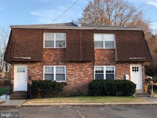
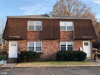
16 Apel Ave
Oreland, PA 19075
Today
Favorites
215-233-5000
-
Bedrooms
2
-
Bathrooms
1
-
Square Feet
--
-
Available
Available Now
Highlight
- Forced Air Heating and Cooling System
16 Apel Ave

Favorites
About This Home
Available Now
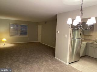
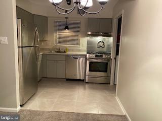
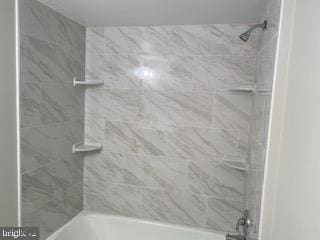
Recently renovated (4Yrs) 2nd Floor Two Bedroom Brick Duplex. Living Rm, modern Kitchen with Dining Area, Ceramic Tile Bath, spacious Main Bedroom 14'6 X 11'4" accommodates King Size bed, triple dresser wall space with an entire 11' double closet. 2nd BR or Office 10'6" X 8'11". Utility room with your own Laundry hook ups. Washer /Dryer supplied. Energy efficient vinyl double hung thermo-pane windows, gas heat, gas hot water and gas cooking. Central Air Conditioning. Wall to wall carpet. The village of Oreland Springfield Township in East Montgomery County is between Glenside, Flourtown and Fort Washington. Within one block there is a Diner, Food Mart, Pizza Shop and Dry Cleaner. Short drive to Chestnut Hill restaurants and or shopping, Abington Hospital, Temple's Ambler Campus, Westminster Seminary, Arcadia University, Willow Grove Mall, Keswick Theater, and the Fort Washington or Horsham Business Campuses. The local Oreland Train station, only four blocks away, is serviced by the Septa Regional Rail Line by the Lansdale Doylestown line. Bus stop and USPS mail box at your corner. Pennsylvania Turnpike and Fort Washington Route 309 Interchange just 2.2 miles away. Off street parking at your door for one car or additional cars on the dead end street. Verifiable income and minimum credit score of 675 required. Please note apartment is a pet free & Non Smoking/Vaping environment."
16 Apel Ave is a house located in Montgomery County and the 19075 ZIP Code. This area is served by the Springfield Township attendance zone.
* Price shown is base rent and may not include non-optional fees and utilities.
Price, availability, fees, and any applicable rent special are subject to change without notice.
* Square footage definitions vary. Displayed square footage is approximate.
Home Details
Home Type
Semi-Detached or Twin Home
Year Built
Built in 1970
Accessible Home Design
Entry on the 1st floor
Bedrooms and Bathrooms
2 Main Level Bedrooms
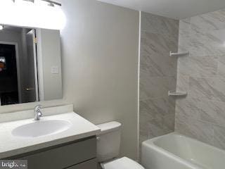
1 Full Bathroom
Home Design
Brick Exterior Construction
Slab Foundation
Interior Spaces
1,025 Sq Ft Home
Property has 2 Levels
Laundry
Laundry in unit
Listing and Financial Details
Security Deposit $1,675
Requires 2 Months of Rent Paid Up Front
12-Month Lease Term
Available 6/16/25
$50 Application Fee
Assessor Parcel Number 52-00-00340-076
Tenant pays for cable TV, electricity, gas, heat, hot water, internet, light bulbs/filters/fuses/alarm care, snow removal, all utilities, water
No Smoking Allowed
Coming Soon on 6/20/25
Residential Lease
Lot Details
10,368 Sq Ft Lot
Lot Dimensions are 80.00 x 0.00
Parking
1 Parking Space
1 Driveway Space
Utilities
Forced Air Heating and Cooling System
Natural Gas Water Heater
Community Details
Overview
Oreland Subdivision
Pet Policy
No Pets Allowed
Contact
- Listed by Christopher S Mood | Dan Helwig Inc
- Phone Number
- Contact
-
Source
 Bright MLS, Inc.
Copyright © 2025 Bright MLS, Inc.
Location
Get Directions
Wyncote-Jenkintown is a suburban section of town about 20 miles north of Downtown Philadelphia. The dynamic area is home to Arcadia University and dotted with green spaces, streams, and golf courses. Easton Road holds an array of locally owned shops, stores, businesses, and a theater. Big-box stores and chain eateries are situated in the corner of town along Cheltenham Avenue at places like Cedarbrook Plaza Shopping Center and Greenleaf at Cheltenham Mall. The rest of Wyncote-Jenkintown features residential neighborhoods holding a variety of apartments and single-family homes suitable for renters from all walks of life.
Learn more about living in Wyncote-Jenkintown
Education
| Colleges & Universities | Distance | ||
|---|---|---|---|
| Colleges & Universities | Distance | ||
| Drive: | 7 min | 2.6 mi | |
| Drive: | 9 min | 4.4 mi | |
| Drive: | 12 min | 5.0 mi | |
| Drive: | 12 min | 5.7 mi |
16 Apel Ave is within 7 minutes or 2.6 miles from Arcadia University. It is also near Salus University and Chesnut Hill College.
Schools


Public Elementary & Middle School
Grades PK-8
250 Students
Nearby
Public Elementary School
Grades 3-5
593 Students
Attendance Zone
Public Elementary School
Grades K-2
565 Students
Attendance Zone
Public Middle School
Grades 6-8
623 Students
Attendance Zone
Public High School
Grades 9-12
765 Students
Attendance Zone
Private Elementary & Middle School
Grades PK-8
576 Students
Nearby
Private Elementary & Middle School
Grades K-8
322 Students
Nearby
Private High School
Grades 9-12
1,064 Students
Nearby
School data provided by
 The GreatSchools Rating helps parents compare schools within a state based on a variety of school quality indicators and provides a helpful picture of how effectively each school serves all of its students. Ratings are on a scale of 1 (below average) to 10 (above average) and can include test scores, college readiness, academic progress, advanced courses, equity, discipline and attendance data. We also advise parents to visit schools, consider other information on school performance and programs, and consider family needs as part of the school selection process.
View GreatSchools Rating Methodology
Data provided by GreatSchools.org © 2025. All rights reserved.
View GreatSchools Rating Methodology
Data provided by GreatSchools.org © 2025. All rights reserved.
Transportation options available in Oreland include Olney, located 6.4 miles from 16 Apel Ave. 16 Apel Ave is near Philadelphia International, located 23.9 miles or 45 minutes away, and Trenton Mercer, located 32.0 miles or 45 minutes away.
| Transit / Subway | Distance | ||
|---|---|---|---|
| Transit / Subway | Distance | ||
|
|
Drive: | 14 min | 6.4 mi |
|
|
Drive: | 15 min | 6.6 mi |
|
|
Drive: | 16 min | 7.0 mi |
|
|
Drive: | 16 min | 7.5 mi |
|
|
Drive: | 17 min | 8.0 mi |
| Commuter Rail | Distance | ||
|---|---|---|---|
| Commuter Rail | Distance | ||
|
|
Walk: | 6 min | 0.3 mi |
|
|
Walk: | 14 min | 0.8 mi |
|
|
Drive: | 4 min | 1.8 mi |
|
|
Drive: | 5 min | 2.0 mi |
|
|
Drive: | 5 min | 2.4 mi |
| Airports | Distance | ||
|---|---|---|---|
| Airports | Distance | ||
|
Philadelphia International
|
Drive: | 45 min | 23.9 mi |
|
Trenton Mercer
|
Drive: | 45 min | 32.0 mi |
Time and distance from 16 Apel Ave.
| Shopping Centers | Distance | ||
|---|---|---|---|
| Shopping Centers | Distance | ||
| Walk: | 10 min | 0.5 mi | |
| Drive: | 3 min | 1.2 mi | |
| Drive: | 3 min | 1.3 mi |
16 Apel Ave has 3 shopping centers within 1.3 miles, which is about a 3-minute walk. The miles and minutes will be for the farthest away property.
| Parks and Recreation | Distance | ||
|---|---|---|---|
| Parks and Recreation | Distance | ||
|
Wissahickon Valley Park
|
Drive: | 5 min | 2.6 mi |
|
Briar Bush Nature Center
|
Drive: | 7 min | 3.4 mi |
|
Fort Washington State Park
|
Drive: | 10 min | 3.5 mi |
|
The Morris Arboretum
|
Drive: | 12 min | 4.6 mi |
|
Wissahickon Environmental Center
|
Drive: | 11 min | 4.9 mi |
16 Apel Ave has 5 parks within 4.9 miles, including Wissahickon Valley Park, Briar Bush Nature Center, and Fort Washington State Park.
| Hospitals | Distance | ||
|---|---|---|---|
| Hospitals | Distance | ||
| Drive: | 6 min | 2.8 mi | |
| Drive: | 9 min | 4.1 mi | |
| Drive: | 10 min | 4.2 mi |
16 Apel Ave has 3 hospitals within 4.2 miles, the nearest is Brooke Glen Behavioral Hospital which is 2.8 miles away and a 6 minute drive.
| Military Bases | Distance | ||
|---|---|---|---|
| Military Bases | Distance | ||
| Drive: | 17 min | 7.8 mi |
16 Apel Ave is 7.8 miles and a 17 minute drive from Willow Grove Naval Air Station.
You May Also Like
Similar Rentals Nearby


What Are Walk Score®, Transit Score®, and Bike Score® Ratings?
Walk Score® measures the walkability of any address. Transit Score® measures access to public transit. Bike Score® measures the bikeability of any address.
What is a Sound Score Rating?
A Sound Score Rating aggregates noise caused by vehicle traffic, airplane traffic and local sources
16 Apel Ave
Oreland, PA 19075