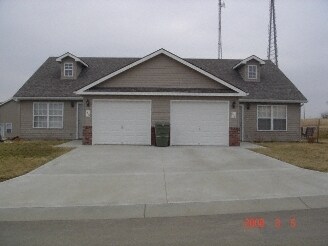
1524-1526 Eagle Dr

1524-1526 Eagle Dr, Pleasant Hill, MO 64080

2 Weeks Ago
Share Listing
Favorites
1524-1526 Eagle Dr
Share Listing
Favorites

About 1524-1526 Eagle Dr Pleasant Hill, MO 64080

Visit 1524-1526 Eagle Dr. The location in Pleasant Hill's 64080 area has so much to offer its residents. Here at this community, the professional leasing staff is ready to help match you with the perfect apartment. Come by to see the current floorplan options. At 1524-1526 Eagle Dr you'll feel right at home.

1524-1526 Eagle Dr is an apartment community located in Cass County and the 64080 ZIP Code. This area is served by the Pleasant Hill R-Iii School District attendance zone.
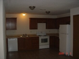
Apartment Features

Air Conditioning

Refrigerator

Heating

Oven

  • Air Conditioning
  • Heating
  • Wheelchair Accessible (Rooms)
  • Kitchen
  • Oven
  • Range
  • Refrigerator
Location
1524-1526 Eagle Dr, Pleasant Hill,
MO 64080
Get Directions
Education
Colleges & Universities Distance
Drive: 34 min 19.3 mi
Drive: 50 min 30.4 mi
Drive: 46 min 30.5 mi
Drive: 49 min 32.7 mi
1524-1526 Eagle Dr is within 34 minutes or 19.3 miles from Metropolitan Community College. It is also near Avila University and Graceland University.
Schools
Public Elementary School
Grades K-5
333 Students
Nearby
Public Elementary School
Grades K-5
306 Students
Nearby
Public Elementary School
Grades PK-5
490 Students
Nearby
Public Middle School
Grades 6-8
356 Students
Nearby
Public High School
Grades 9-12
712 Students
Nearby
Private Elementary, Middle & High School
Grades PK-12
662 Students
Nearby
Private Elementary & Middle School
Grades K-8
28 Students
Nearby
Private Elementary, Middle & High School
Grades K-12
Nearby
Transportation
Commuter Rail Distance
Drive: 26 min 15.5 mi
Drive: 48 min 30.0 mi
Drive: 56 min 34.0 mi
Drive: 53 min 37.7 mi

Walkability Near 1524-1526 Eagle Dr Pleasant Hill, MO 64080

Getting Around
Somewhat Walkable
Walkability
20 / 100
Exceptionally Drivable
Drivability
100 / 100
Somewhat Bikeable
Bikeability
30 / 100

Scores provided by

What do Walkability, Transit, Drivability, and Bikeability mean? Walkability measures the walking distance to day-to-day needs. Transit measures access to public transportation. Drivability measures congestion, parking availability, and access to major roads. Bikeability measures the suitability for cycling. How It Works
-
Soundscore
- / 100

Traffic

-

Airport

-

Businesses

-

Scores provided by

HowLoud What is a Sound Score Rating? A Sound Score Rating aggregates noise caused by vehicle traffic, airplane traffic and local sources.
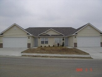
 How It Works
Points of Interest

Time and distance from 1524-1526 Eagle Dr.

Shopping Centers Distance
Drive: 4 min 1.3 mi
Drive: 21 min 11.1 mi
Drive: 25 min 12.5 mi
1524-1526 Eagle Dr has 3 shopping centers within 12.5 miles, which is about a 25-minute drive. The miles and minutes will be for the farthest away property.
Hospitals Distance
Hospitals Distance
Drive: 23 min 12.6 mi
1524-1526 Eagle Dr is 12.6 miles and a 23 minute drive from Lee's Summit Medical Center.
Military Bases Distance
Drive: 92 min 55.9 mi
Drive: 101 min 74.7 mi
1524-1526 Eagle Dr is 55.9 miles from Whiteman Air Force Base, and is convenient to other military bases, including Fort Leavenworth.

Explore Similar Rentals Nearby