
-
Pet Friendly 3 Bed 2 Bath in the Burnt Bri...

$2,395 / Month
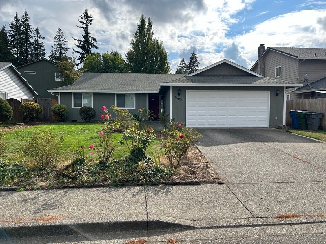
15009 NE 51st St
Vancouver, WA 98682
2 Weeks Ago
Favorites
-
Bedrooms
3
-
Bathrooms
1.5
-
Square Feet
1,448 sq ft
15009 NE 51st St

Favorites
About This Home
$2,395 deposit
Find a home in this established Burnt Bridge Creek Neighborhood with easy access to NE 162nd Ave and Fourth Plain Blvd. Both these roads will take you to rest of Vancouver or further out into Battle Ground and Brush Prairie. With local amenities such as Safeway, Walmart and more for your use. As you approach the home you will come across a beautiful front yard and a walkway with a covered entry. Once inside be greeted with you living room, if you go right you’ll find the kitchen and family with a slider into the backyard. Going left will take you to the three bedrooms and two bathrooms, with two of the bedrooms overlooking the front yard. This home will be apart of the Evergreen School District which has local schools such as Burnt Bridge Creek Elementary, which is a short distance from the home, Frontier Middle, and Union High School. The area also has some local outdoor amenities such as Fir Garden Park, Nikkei Park, and many more in the area. So reach out today at to see how you can schedule a tour or to APPLY NOW!!! -EB/TJ *Please note: photos may not accurately reflect the layout or finishes for this unit. Actual finishes and/or features may vary. Owner/agent assumes no responsibility for discrepancies between pictures and final product. Please conduct a self-tour to view the property.
15009 NE 51st St is a house located in Clark County and the 98682 ZIP Code. This area is served by the Evergreen School District (Clark) attendance zone.
* Price shown is base rent and may not include non-optional fees and utilities.
Price, availability, fees, and any applicable rent special are subject to change without notice.
* Square footage definitions vary. Displayed square footage is approximate.
House Features
- Dishwasher
Contact
- Listed by The Management Group, Inc | The Management Group, Inc
Location
Get Directions
Amenities
- Dishwasher
On the north bank of the Columbia River, separating Washington from Oregon, lies Portland’s largest suburb and the fourth largest city in Washington: Vancouver. This riverfront retreat is filled with a rich history, abundance of shopping, outdoor recreation, and a family-friendly atmosphere. With excellent public schools like Hudson Bay High School, families flock to this thriving suburb. There are more than enough community parks to keep outdoor lovers content, including Vancouver Lake Regional Park, LeRoy Haagen Memorial Community Park, Orchards Community Park, Esther Short Park and Playground, and Frenchman’s Bar Regional Park, a fisherman’s oasis.
Interstates 5 and 205 run directly through town, connecting Vancouver to Portland, so commuting is a breeze – not to mention Vancouver is just across the river from the Portland International Airport.
Learn more about living in Vancouver
Education
| Colleges & Universities | Distance | ||
|---|---|---|---|
| Colleges & Universities | Distance | ||
| Drive: | 15 min | 7.0 mi | |
| Drive: | 16 min | 7.9 mi | |
| Drive: | 20 min | 10.6 mi | |
| Drive: | 23 min | 11.1 mi |
15009 NE 51st St is within 15 minutes or 7.0 miles from Clark College, Town Plaza. It is also near Clark College, Vancouver and Mount Hood C.C., Maywood Park.
Schools


Public Elementary School
Grades PK-5
377 Students
Attendance Zone
Public Middle School
Grades 6-8
800 Students
Attendance Zone
Public High School
Grades 9-12
2,021 Students
Attendance Zone
Private Elementary & Middle School
Grades 1-8
99 Students
Nearby
Private Elementary & Middle School
Grades K-8
131 Students
Nearby
Private High School
Grades 9-12
118 Students
Nearby
School data provided by
 The GreatSchools Rating helps parents compare schools within a state based on a variety of school quality indicators and provides a helpful picture of how effectively each school serves all of its students. Ratings are on a scale of 1 (below average) to 10 (above average) and can include test scores, college readiness, academic progress, advanced courses, equity, discipline and attendance data. We also advise parents to visit schools, consider other information on school performance and programs, and consider family needs as part of the school selection process.
View GreatSchools Rating Methodology
Data provided by GreatSchools.org © 2025. All rights reserved.
View GreatSchools Rating Methodology
Data provided by GreatSchools.org © 2025. All rights reserved.
Transportation options available in Vancouver include Mt Hood Avenue, located 9.9 miles from 15009 NE 51st St. 15009 NE 51st St is near Portland International, located 11.1 miles or 21 minutes away.
| Transit / Subway | Distance | ||
|---|---|---|---|
| Transit / Subway | Distance | ||
|
|
Drive: | 19 min | 9.9 mi |
|
|
Drive: | 19 min | 10.0 mi |
|
|
Drive: | 21 min | 11.1 mi |
|
|
Drive: | 21 min | 12.6 mi |
|
|
Drive: | 24 min | 14.7 mi |
| Commuter Rail | Distance | ||
|---|---|---|---|
| Commuter Rail | Distance | ||
|
|
Drive: | 19 min | 10.2 mi |
|
|
Drive: | 28 min | 16.9 mi |
|
|
Drive: | 39 min | 24.6 mi |
|
|
Drive: | 41 min | 26.4 mi |
|
|
Drive: | 44 min | 26.9 mi |
| Airports | Distance | ||
|---|---|---|---|
| Airports | Distance | ||
|
Portland International
|
Drive: | 21 min | 11.1 mi |
Time and distance from 15009 NE 51st St.
| Shopping Centers | Distance | ||
|---|---|---|---|
| Shopping Centers | Distance | ||
| Drive: | 5 min | 1.8 mi | |
| Drive: | 5 min | 1.9 mi | |
| Drive: | 5 min | 2.2 mi |
15009 NE 51st St has 3 shopping centers within 2.2 miles, which is about a 5-minute drive. The miles and minutes will be for the farthest away property.
| Parks and Recreation | Distance | ||
|---|---|---|---|
| Parks and Recreation | Distance | ||
|
Diamond Park
|
Walk: | 20 min | 1.1 mi |
|
Pacific Community Park
|
Drive: | 6 min | 2.6 mi |
|
LeRoy Haagen Memorial Park
|
Drive: | 7 min | 2.9 mi |
|
Hearthwood Park
|
Drive: | 8 min | 3.1 mi |
|
Tiger Tree Neighborhood Park
|
Drive: | 8 min | 3.4 mi |
15009 NE 51st St has 5 parks within 3.4 miles, including Diamond Park, Pacific Community Park, and LeRoy Haagen Memorial Park.
| Hospitals | Distance | ||
|---|---|---|---|
| Hospitals | Distance | ||
| Drive: | 14 min | 6.1 mi | |
| Drive: | 16 min | 9.2 mi |
15009 NE 51st St is 6.1 miles from PeaceHealth Southwest Medical Center, and is convenient to other hospitals, including Legacy Salmon Creek Medical Center.
| Military Bases | Distance | ||
|---|---|---|---|
| Military Bases | Distance | ||
| Drive: | 19 min | 8.8 mi | |
| Drive: | 22 min | 11.7 mi |
15009 NE 51st St is 8.8 miles from Camp Bonneville Military Reservation, and is convenient to other military bases, including Portland Airport Air Guard Station.
You May Also Like
Similar Rentals Nearby


What Are Walk Score®, Transit Score®, and Bike Score® Ratings?
Walk Score® measures the walkability of any address. Transit Score® measures access to public transit. Bike Score® measures the bikeability of any address.
What is a Sound Score Rating?
A Sound Score Rating aggregates noise caused by vehicle traffic, airplane traffic and local sources
15009 NE 51st St
Vancouver, WA 98682