

$1,800 / Month
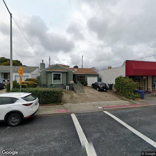
150 Hazelwood Dr
South San Francisco, CA 94080
2 Weeks Ago
Favorites
150 Hazelwood Dr

Favorites
Check Back Soon for Upcoming Availability
| Beds | Baths | Average SF |
|---|---|---|
| 4 Bedrooms 4 Bedrooms 4 Br | 3 Baths 3 Baths 3 Ba | 1,600 SF |
Fees and Policies
The fees below are based on community-supplied data and may exclude additional fees and utilities.
- Parking
-
Street--
Details
Utilities Included
-
Gas
-
Water
-
Electricity
-
Heat
-
Trash Removal
-
Sewer
-
Cable
150 Hazelwood Dr is a house located in San Mateo County and the 94080 ZIP Code.
House Features
Washer/Dryer
High Speed Internet Access
Wi-Fi
Heating
- High Speed Internet Access
- Wi-Fi
- Washer/Dryer
- Heating
Location
Get Directions
Avalon is a cozy residential neighborhood along Interstate 280 in South San Francisco. The community is bordered to the north by California Golf Club of San Francisco and to the south by Golden Gate National Cemetery, giving the neighborhood a tranquil atmosphere. Ponderosa Elementary School and Baden High School are both located on the east side, with Los Cerritos Elementary and South San Francisco High School right across El Camino Real, making this a great location for those with school-age kids.
Residents enjoy close access to a handful of shopping centers, with the Shops at Tanforan mall offering up specialty shops, casual dining, and a multiplex movie theater. With the Interstate and San Francisco international Airport close at hand as well, it’s an ideal spot for commuters and frequent travelers.
Learn more about living in AvalonBelow are rent ranges for similar nearby apartments
Amenities
- High Speed Internet Access
- Wi-Fi
- Washer/Dryer
- Heating
Expenses
Utilities Included
Gas, Water, Electricity, Heat, Trash Removal, Sewer, Cable
Included
Education
| Colleges & Universities | Distance | ||
|---|---|---|---|
| Colleges & Universities | Distance | ||
| Drive: | 7 min | 3.6 mi | |
| Drive: | 14 min | 7.8 mi | |
| Drive: | 14 min | 8.2 mi | |
| Drive: | 20 min | 10.4 mi |
150 Hazelwood Dr is within 7 minutes or 3.6 miles from Skyline College. It is also near City College of San Francisco and San Francisco State University.
Transportation options available in South San Francisco include San Bruno, located 0.9 mile from 150 Hazelwood Dr. 150 Hazelwood Dr is near San Francisco International, located 4.0 miles or 9 minutes away, and Metro Oakland International, located 29.9 miles or 44 minutes away.
| Transit / Subway | Distance | ||
|---|---|---|---|
| Transit / Subway | Distance | ||
|
|
Walk: | 16 min | 0.9 mi |
|
|
Drive: | 4 min | 2.0 mi |
|
|
Drive: | 4 min | 2.0 mi |
| Drive: | 5 min | 2.5 mi | |
| Drive: | 5 min | 2.7 mi |
| Commuter Rail | Distance | ||
|---|---|---|---|
| Commuter Rail | Distance | ||
| Drive: | 3 min | 1.5 mi | |
| Drive: | 5 min | 2.2 mi | |
| Drive: | 8 min | 4.3 mi | |
| Drive: | 10 min | 6.1 mi | |
| Drive: | 11 min | 6.7 mi |
| Airports | Distance | ||
|---|---|---|---|
| Airports | Distance | ||
|
San Francisco International
|
Drive: | 9 min | 4.0 mi |
|
Metro Oakland International
|
Drive: | 44 min | 29.9 mi |
Time and distance from 150 Hazelwood Dr.
| Shopping Centers | Distance | ||
|---|---|---|---|
| Shopping Centers | Distance | ||
| Walk: | 1 min | 0.1 mi | |
| Walk: | 9 min | 0.5 mi | |
| Walk: | 13 min | 0.7 mi |
150 Hazelwood Dr has 3 shopping centers within 0.7 mile, which is about a 13-minute walk. The miles and minutes will be for the farthest away property.
| Parks and Recreation | Distance | ||
|---|---|---|---|
| Parks and Recreation | Distance | ||
|
Bayside Park
|
Drive: | 10 min | 6.4 mi |
|
Candlestick Point State Recreation Area
|
Drive: | 15 min | 7.5 mi |
|
Pacifica State Beach
|
Drive: | 13 min | 8.0 mi |
|
San Bruno Mountain State Park
|
Drive: | 18 min | 8.2 mi |
|
San Pedro Valley Park
|
Drive: | 21 min | 10.2 mi |
150 Hazelwood Dr has 5 parks within 10.2 miles, including San Bruno Mountain State Park, Bayside Park, and Pacifica State Beach.
| Hospitals | Distance | ||
|---|---|---|---|
| Hospitals | Distance | ||
| Drive: | 2 min | 1.5 mi | |
| Drive: | 7 min | 4.2 mi | |
| Drive: | 8 min | 4.3 mi |
150 Hazelwood Dr has 3 hospitals within 4.3 miles, the nearest is Kaiser Foundation Hospital - South San Francisco which is 1.5 miles away and a 2 minute drive.
| Military Bases | Distance | ||
|---|---|---|---|
| Military Bases | Distance | ||
| Drive: | 27 min | 12.4 mi | |
| Drive: | 27 min | 13.0 mi |
150 Hazelwood Dr is 12.4 miles from East Fort Miley, and is convenient to other military bases, including West Fort Miley.
You May Also Like
Similar Rentals Nearby


What Are Walk Score®, Transit Score®, and Bike Score® Ratings?
Walk Score® measures the walkability of any address. Transit Score® measures access to public transit. Bike Score® measures the bikeability of any address.
What is a Sound Score Rating?
A Sound Score Rating aggregates noise caused by vehicle traffic, airplane traffic and local sources
150 Hazelwood Dr
South San Francisco, CA 94080