
$3,750
Total Monthly Price
12 Month Lease
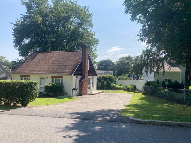
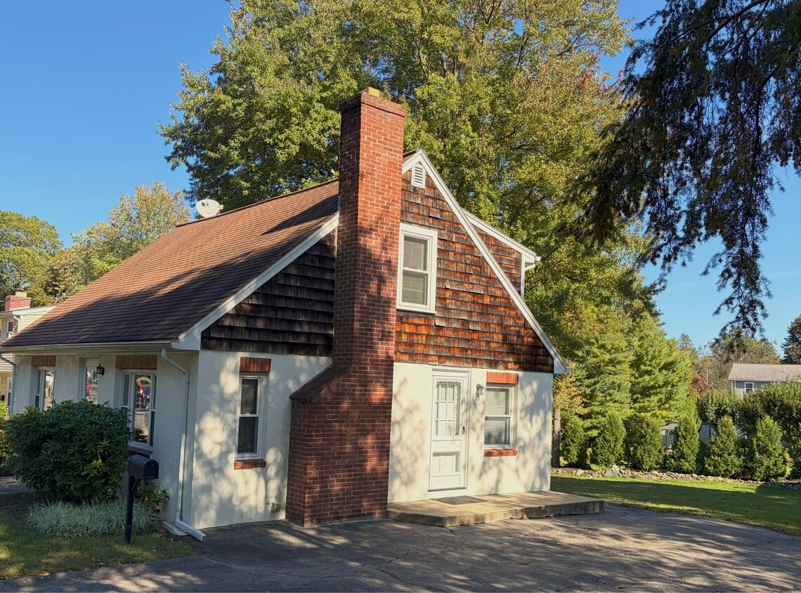
15 Willard St
Waltham, MA 02451
2 Weeks Ago
|
Edit
Favorites
781-622-9097
-
Bedrooms
3
-
Bathrooms
1.5
-
Square Feet
1,400 sq ft
-
Available
Available Now
Highlights
- Hardwood Floors
- Yard
- Basement
15 Willard St

Favorites
About This Home
12 Month Lease,
$1,000 deposit,
Available Now
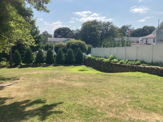
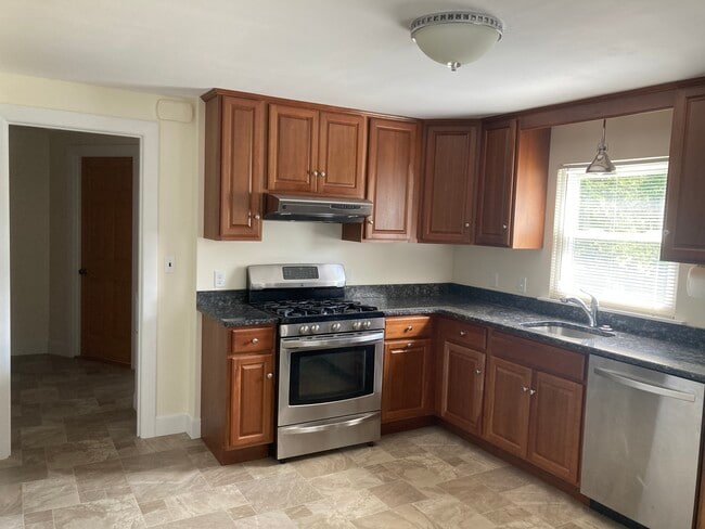
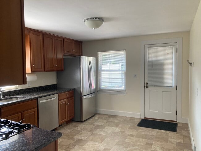
No fee. Six room, Three bedroom Cape-style house on a dead-end street. Double driveway for 4 cars. Large yard. Kitchen has Stainless steel appliances & Granite counter tops. Hardwood floors throughout. Freshly Painted. Washer & Dryer. Full basement. 5 minute drive to Rte 95/128. Beautiful hiking trails nearby ( Rail Trail & Prospect Hill Park). Tenant pays utilities (Electric & Gas & Cable) First & Last month's rent, Security Deposit. Smoking outside only. Cat ok.
15 Willard St is a house located in Middlesex County and the 02451 ZIP Code. This area is served by the Waltham attendance zone.
* Price shown is total price based on community-supplied monthly required fees. Excludes user-selected optional fees and variable or usage-based fees and required charges due at or prior to move-in or at move-out. Price, availability, fees, and any applicable rent special are subject to change without notice.
* Square footage definitions vary. Displayed square footage is approximate.
House Features
Washer/Dryer
Hardwood Floors
Granite Countertops
Tub/Shower
- Washer/Dryer
- Cable Ready
- Storage Space
- Tub/Shower
- Granite Countertops
- Stainless Steel Appliances
- Kitchen
- Hardwood Floors
- Basement
- Walking/Biking Trails
- Yard
Fees and Policies
The fees below are based on community-supplied data and may exclude additional fees and utilities.
- One-Time Move-In Fees
-
Broker Fee$0
- Cats Allowed
-
Fees not specified
-
Weight limit--
-
Pet Limit--
- Parking
-
Surface Lot--
Details
Utilities Included
-
Water
-
Trash Removal
-
Sewer
Contact
- Listed by John DeCola
- Phone Number
- Contact
Location
Get Directions
Located 11 miles west of Boston along the Charles River, Waltham combines metropolitan accessibility with tree-lined neighborhoods. The city earned its "Watch City" nickname through its historic watchmaking industry and now houses both Brandeis and Bentley Universities. The rental market remains competitive, with average rents ranging from $2,002 for studios to $3,843 for three-bedroom units. Housing options span from riverside apartment communities to historic homes in established neighborhoods like Piety Corner and the Highlands.
Moody Street, known locally as "Restaurant Row," serves as the city's downtown hub, featuring an international array of restaurants and independent shops. The Charles River Museum of Industry & Innovation chronicles the area's manufacturing legacy, while the riverside paths offer miles of walking and cycling routes. Residents enjoy access to several parks and green spaces, including the preserved Gore Place estate and the scenic Prospect Hill Park.
Learn more about living in Waltham
Education
| Colleges & Universities | Distance | ||
|---|---|---|---|
| Colleges & Universities | Distance | ||
| Drive: | 6 min | 2.2 mi | |
| Drive: | 7 min | 2.2 mi | |
| Drive: | 17 min | 6.9 mi | |
| Drive: | 15 min | 7.3 mi |
15 Willard St is within 7 minutes or 2.2 miles from Brandeis University. It is also near Bentley University and Boston College.
Schools


Public Elementary School
Grades PK-5
383 Students
Nearby
Public Elementary School
Grades K-5
353 Students
Attendance Zone
Public Middle School
Grades 6-8
600 Students
Attendance Zone
Public High School
Grades 9-12
1,751 Students
Attendance Zone
Private Elementary & Middle School
Grades PK-8
343 Students
Nearby
Private Elementary & Middle School
Grades PK-8
115 Students
Nearby
Private Elementary, Middle & High School
Grades 3-12
73 Students
Nearby
School data provided by
 The GreatSchools Rating helps parents compare schools within a state based on a variety of school quality indicators and provides a helpful picture of how effectively each school serves all of its students. Ratings are on a scale of 1 (below average) to 10 (above average) and can include test scores, college readiness, academic progress, advanced courses, equity, discipline and attendance data. We also advise parents to visit schools, consider other information on school performance and programs, and consider family needs as part of the school selection process.
View GreatSchools Rating Methodology
Data provided by GreatSchools.org © 2025. All rights reserved.
View GreatSchools Rating Methodology
Data provided by GreatSchools.org © 2025. All rights reserved.
Transportation options available in Waltham include Riverside Station, located 4.1 miles from 15 Willard St. 15 Willard St is near General Edward Lawrence Logan International, located 15.3 miles or 27 minutes away, and Worcester Regional, located 41.0 miles or 60 minutes away.
| Transit / Subway | Distance | ||
|---|---|---|---|
| Transit / Subway | Distance | ||
|
|
Drive: | 10 min | 4.1 mi |
|
|
Drive: | 10 min | 4.7 mi |
|
|
Drive: | 12 min | 5.3 mi |
|
|
Drive: | 15 min | 6.0 mi |
|
|
Drive: | 13 min | 6.1 mi |
| Commuter Rail | Distance | ||
|---|---|---|---|
| Commuter Rail | Distance | ||
|
|
Drive: | 4 min | 1.6 mi |
| Drive: | 4 min | 1.6 mi | |
|
|
Drive: | 5 min | 2.2 mi |
|
|
Drive: | 5 min | 2.5 mi |
| Drive: | 9 min | 4.4 mi |
| Airports | Distance | ||
|---|---|---|---|
| Airports | Distance | ||
|
General Edward Lawrence Logan International
|
Drive: | 27 min | 15.3 mi |
|
Worcester Regional
|
Drive: | 60 min | 41.0 mi |
Time and distance from 15 Willard St.
| Shopping Centers | Distance | ||
|---|---|---|---|
| Shopping Centers | Distance | ||
| Walk: | 17 min | 0.9 mi | |
| Walk: | 18 min | 0.9 mi | |
| Drive: | 5 min | 1.8 mi |
15 Willard St has 3 shopping centers within 1.8 miles, which is about a 5-minute walk. The miles and minutes will be for the farthest away property.
| Parks and Recreation | Distance | ||
|---|---|---|---|
| Parks and Recreation | Distance | ||
|
Beaver Brook Reservation
|
Drive: | 7 min | 3.3 mi |
|
Land's Sake Farm
|
Drive: | 8 min | 3.7 mi |
|
Mass Audubon's Habitat Education Center and Wildlife Sanctuary
|
Drive: | 11 min | 5.1 mi |
|
Mass Audubon's Drumlin Farm Wildlife Sanctuary
|
Drive: | 11 min | 6.1 mi |
|
Codman Community Farms
|
Drive: | 12 min | 6.2 mi |
15 Willard St has 5 parks within 6.2 miles, including Beaver Brook Reservation, Land's Sake Farm, and Mass Audubon's Habitat Education Center and Wildlife Sanctuary.
| Hospitals | Distance | ||
|---|---|---|---|
| Hospitals | Distance | ||
| Drive: | 4 min | 1.5 mi | |
| Drive: | 7 min | 3.7 mi | |
| Drive: | 10 min | 5.7 mi |
15 Willard St has 3 hospitals within 5.7 miles, the nearest is Walden Behavioral Care which is 1.5 miles away and a 4 minute drive.
| Military Bases | Distance | ||
|---|---|---|---|
| Military Bases | Distance | ||
| Drive: | 16 min | 7.4 mi | |
| Drive: | 21 min | 11.5 mi |
15 Willard St is 7.4 miles from Hanscom Air Force Base, and is convenient to other military bases, including US Military Reservation.
Amenities
- Washer/Dryer
- Cable Ready
- Storage Space
- Tub/Shower
- Granite Countertops
- Stainless Steel Appliances
- Kitchen
- Hardwood Floors
- Basement
- Yard
- Walking/Biking Trails
15 Willard St Photos
What Are Walk Score®, Transit Score®, and Bike Score® Ratings?
Walk Score® measures the walkability of any address. Transit Score® measures access to public transit. Bike Score® measures the bikeability of any address.
What is a Sound Score Rating?
A Sound Score Rating aggregates noise caused by vehicle traffic, airplane traffic and local sources
15 Willard St
Waltham, MA 02451