

$4,200
/ Month
15 Japala Ct
Fremont, CA 94539
2 Weeks Ago
|
Edit
Favorites
15 Japala Ct

Favorites
Check Back Soon for Upcoming Availability
| Beds | Baths | Average SF |
|---|---|---|
| 3 Bedrooms 3 Bedrooms 3 Br | 3 Baths 3 Baths 3 Ba | 1,617 SF |
About This Property
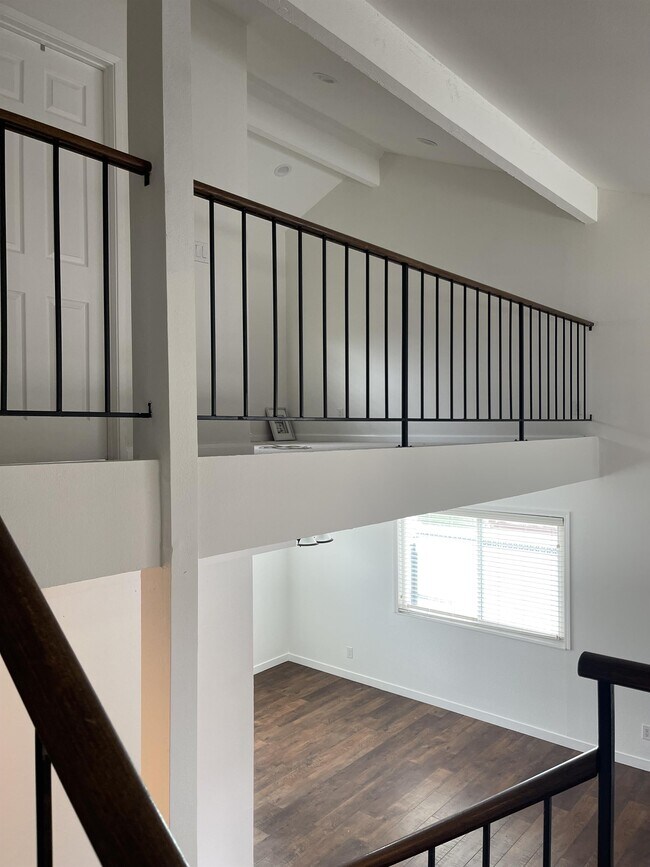
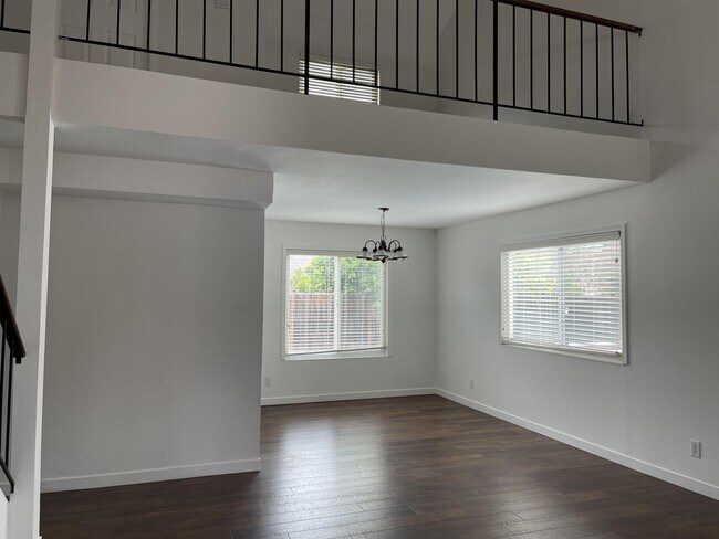
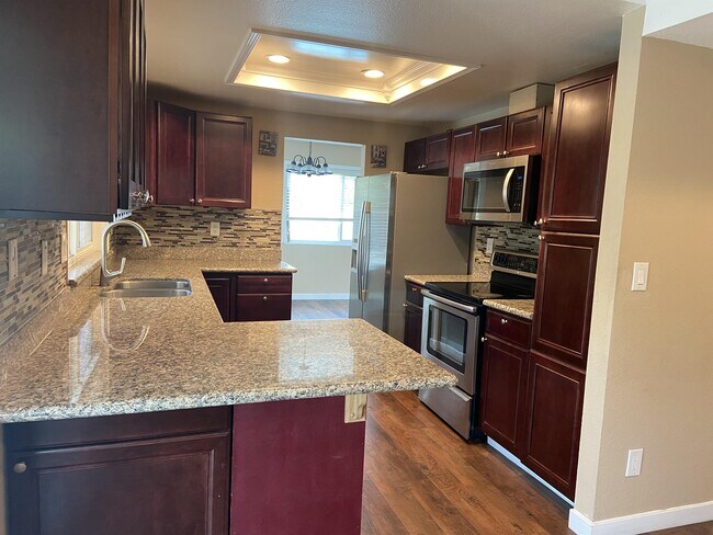
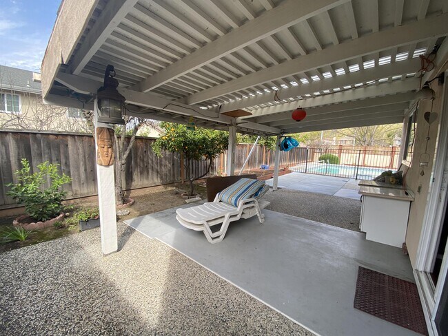
BEAUTIFUL HOME NEAR MISSION PEAK TRAIL. NICE BIG BACK YARD WITH POOL * Spacious master bedroom with big walk-in closet with closet organizer * Bonus area upstairs that can be used as office or kids' play area * Outside entertainment area * Cozy fireplace with spacious living room * Refrigerator, electric range, microwave with hood and dishwasher * Central AC AND HEAT * Attached 2-Car Garage and plenty of off-street parking * Walking distance from the shopping center and 6min drive. Home depot, Costco, Walmart * 4 min from park and 5 min from mission peak trail * Near good schools and at the end of a cul de sac. Safe for children The owner pays, gardener and pool maintenance. Pets allowed and will be considered No Smoking, please Credit Check Required. Good Credit and References are important.
15 Japala Ct is a house located in Alameda County and the 94539 ZIP Code. This area is served by the Fremont Unified School District attendance zone.
House Features
- Pool
15 Japala Ct,
Fremont,
CA
94539
Fremont, positioned in the San Francisco Bay Area, combines suburban living with innovation and technology. As home to the Tesla Factory, the city maintains a strong industrial presence while offering numerous parks and outdoor spaces. Lake Elizabeth in Central Park provides recreational opportunities, while Mission Peak's trails showcase panoramic Bay Area views. The rental market remains competitive, with average rents ranging from $2,204 for studios to $3,770 for three-bedroom homes, with year-over-year increases between 1.5% and 4.4%.
The city's five districts each offer distinct characteristics. Historic Niles preserves its early film industry heritage, while Mission San Jose features the restored Mission San José, an architectural landmark from 1797. The Warm Springs area has developed into a technology center, and Central Fremont includes shopping destinations like the Fremont Hub and Pacific Commons.
Learn more about living in Fremont
Amenities
- Pool
Education
| Colleges & Universities | Distance | ||
|---|---|---|---|
| Colleges & Universities | Distance | ||
| Drive: | 2 min | 1.2 mi | |
| Drive: | 9 min | 5.3 mi | |
| Drive: | 14 min | 9.6 mi | |
| Drive: | 20 min | 14.4 mi |
15 Japala Ct is within 2 minutes or 1.2 miles from Ohlone College, Fremont Campus. It is also near Ohlone College, Newark and Palmer College of Chiropractic West Campus.
Schools


Public Elementary School
Grades K-5
373 Students
Nearby
Public Elementary School
Grades K-5
362 Students
Attendance Zone
Public Middle School
Grades 6-8
1,574 Students
Attendance Zone
Public High School
Grades 9-12
2,157 Students
Attendance Zone
Private Elementary School
Grades PK-5
221 Students
Nearby
Private Middle & High School
Grades 6-12
Nearby
School data provided by
 The GreatSchools Rating helps parents compare schools within a state based on a variety of school quality indicators and provides a helpful picture of how effectively each school serves all of its students. Ratings are on a scale of 1 (below average) to 10 (above average) and can include test scores, college readiness, academic progress, advanced courses, equity, discipline and attendance data. We also advise parents to visit schools, consider other information on school performance and programs, and consider family needs as part of the school selection process.
View GreatSchools Rating Methodology
Data provided by GreatSchools.org © 2026. All rights reserved.
View GreatSchools Rating Methodology
Data provided by GreatSchools.org © 2026. All rights reserved.
Transportation options available in Fremont include Warm Springs / South Fremont, located 2.2 miles from 15 Japala Ct. 15 Japala Ct is near Norman Y Mineta San Jose International, located 13.7 miles or 18 minutes away, and Metro Oakland International, located 25.2 miles or 33 minutes away.
| Transit / Subway | Distance | ||
|---|---|---|---|
| Transit / Subway | Distance | ||
|
|
Drive: | 4 min | 2.2 mi |
|
|
Drive: | 12 min | 5.7 mi |
|
|
Drive: | 12 min | 8.2 mi |
|
|
Drive: | 12 min | 8.3 mi |
| Drive: | 13 min | 8.5 mi |
| Commuter Rail | Distance | ||
|---|---|---|---|
| Commuter Rail | Distance | ||
| Drive: | 13 min | 6.5 mi | |
| Drive: | 12 min | 8.2 mi | |
| Drive: | 15 min | 11.2 mi | |
| Drive: | 18 min | 13.0 mi | |
| Drive: | 21 min | 14.4 mi |
| Airports | Distance | ||
|---|---|---|---|
| Airports | Distance | ||
|
Norman Y Mineta San Jose International
|
Drive: | 18 min | 13.7 mi |
|
Metro Oakland International
|
Drive: | 33 min | 25.2 mi |
Walkability Near 15 Japala Ct Fremont, CA 94539
Getting Around
 What do Walkability, Transit, Drivability, and Bikeability mean?
Walkability measures the walking distance to day-to-day needs.
Transit measures access to public transportation.
Drivability measures congestion, parking availability, and access to major roads.
Bikeability measures the suitability for cycling.
How It Works
What do Walkability, Transit, Drivability, and Bikeability mean?
Walkability measures the walking distance to day-to-day needs.
Transit measures access to public transportation.
Drivability measures congestion, parking availability, and access to major roads.
Bikeability measures the suitability for cycling.
How It Works
Somewhat Walkable
Walkability
30
/ 100
Limited Public Transit
Transit
20
/ 100
Exceptionally Drivable
Drivability
100
/ 100
Somewhat Bikeable
Bikeability
30
/ 100
Scores provided by
-
Soundscore™
-
/ 100
Traffic
-Airport
-Businesses
-Scores provided by
HowLoud What is a Sound Score Rating? A Sound Score Rating aggregates noise caused by vehicle traffic, airplane traffic and local sources. How It WorksTime and distance from 15 Japala Ct.
| Shopping Centers | Distance | ||
|---|---|---|---|
| Shopping Centers | Distance | ||
| Drive: | 3 min | 1.4 mi | |
| Drive: | 4 min | 2.0 mi | |
| Drive: | 4 min | 2.4 mi |
15 Japala Ct has 3 shopping centers within 2.4 miles, which is about a 4-minute drive. The miles and minutes will be for the farthest away property.
| Parks and Recreation | Distance | ||
|---|---|---|---|
| Parks and Recreation | Distance | ||
|
Central Park (Lake Elizabeth)
|
Drive: | 11 min | 5.7 mi |
|
Mission Peak Regional Preserve
|
Drive: | 19 min | 5.9 mi |
|
Niles Community Park
|
Drive: | 14 min | 6.9 mi |
|
Ed Levin County Park
|
Drive: | 18 min | 10.1 mi |
|
Sunol Regional Wilderness
|
Drive: | 27 min | 12.8 mi |
15 Japala Ct has 5 parks within 12.8 miles, including Mission Peak Regional Preserve, Central Park (Lake Elizabeth), and Niles Community Park.
| Hospitals | Distance | ||
|---|---|---|---|
| Hospitals | Distance | ||
| Drive: | 9 min | 5.0 mi | |
| Drive: | 11 min | 5.9 mi |
15 Japala Ct is 5.0 miles from Kaiser Foundation Hospital - Fremont, and is convenient to other hospitals, including Washington Hospital.
| Military Bases | Distance | ||
|---|---|---|---|
| Military Bases | Distance | ||
| Drive: | 24 min | 16.4 mi |
15 Japala Ct is 16.4 miles and a 24 minute drive from Ames Research Center.
You May Also Like
Similar Rentals Nearby


What Are Walk Score®, Transit Score®, and Bike Score® Ratings?
Walk Score® measures the walkability of any address. Transit Score® measures access to public transit. Bike Score® measures the bikeability of any address.
What is a Sound Score Rating?
A Sound Score Rating aggregates noise caused by vehicle traffic, airplane traffic and local sources.

15 Japala Ct
Fremont, CA 94539