-

-
Matterport 3D Exterior
-
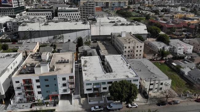
1422 Tamarind Ave
1422 Tamarind Ave,
Los Angeles,
CA
90028
-
Monthly Rent
$2,631 - $3,185
-
Bedrooms
1 - 2 bd
-
Bathrooms
1 - 2 ba
-
Square Feet
665 - 887 sq ft
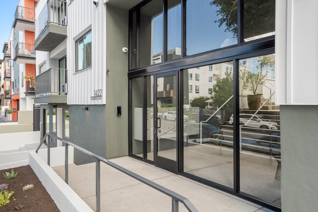
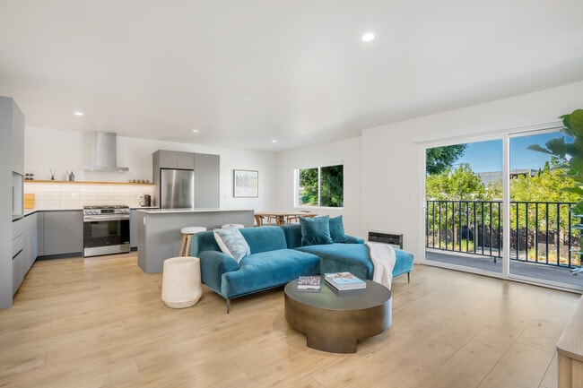
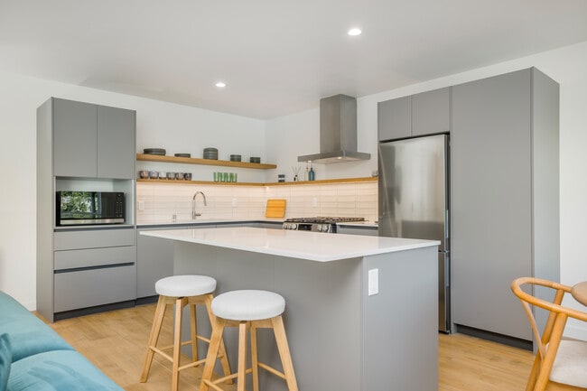
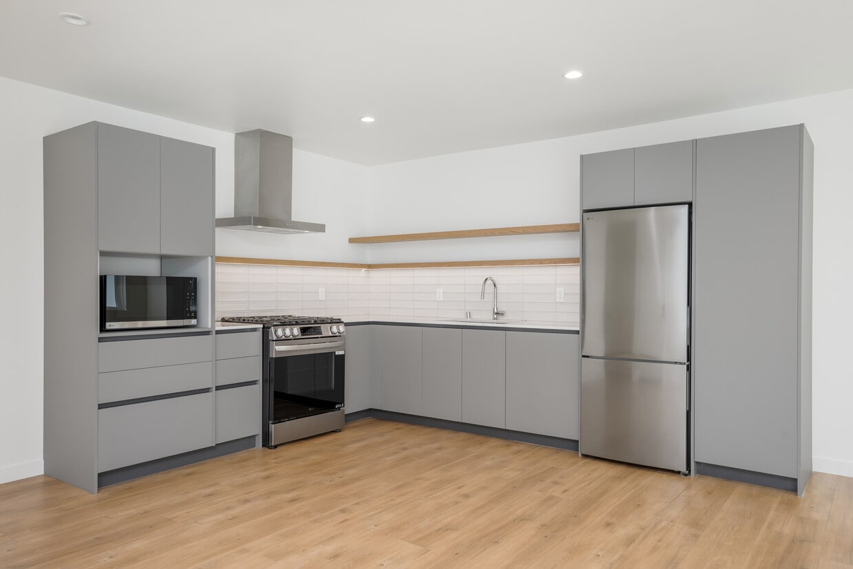
ST Living at 1422 Tamarind | Come Home to Elevated Comfort Welcome to ST Living at 1422 Tamarind Ave, a boutique community where modern renovations meet classic Hollywood charm. Nestled in the heart of Hollywood, just moments from Sunset Boulevard, Franklin Village, and the iconic Hollywood Walk of Fame, 1422 Tamarind Ave offers fully renovated apartment homes designed with today’s lifestyle in mind. Choose from a mix of thoughtfully reimagined studios, one-bedroom, and two-bedroom residences. Each home features open-concept layouts, brand-new stainless steel appliances, in-unit washers and dryers, sleek quartz countertops, and contemporary finishes that bring both style and comfort together. Enjoy the convenience of secured, app-enabled building access and onsite parking, giving you peace of mind in the middle of the city. Originally built with timeless Hollywood character and now fully updated, this intimate property blends historic charm with modern sophistication. Surrounded by a vibrant neighborhood filled with dining, culture, and entertainment, ST Living at 1422 Tamarind Ave places you at the center of it all. Experience the perfect balance of Hollywood energy and modern comfort. 1422 Tamarind is ready to welcome you home. Parking starts $150 Application Fee: $45.00/ Adult Security Deposit: $1,500 - $2,000 on approved credit Tenant pays: all utilities Pets welcome: Call for details REQUIREMENTS: No evictions No criminal record Combined income should be 2.5x the rent 24 months of positive rental history No Bk Satisfactory Credit report The actual rents of the units are $2,850 - $3,350. If you take into consideration the 1 month free concession and divide it over 13 months it's as if you were paying $2,631 - $3,093 per month. The concession cannot be split over the 13 months or given at any other month other than on the 1st or 13th month. Features may not be available for all units, Photos in this ad may not reflect the actual unit or floor plan. Advertised pricing, specials, and availability is subject to change without notice and cannot be guaranteed. Equal Housing Opportunity
Pricing & Floor Plans
-
Unit 3price $2,631square feet 665availibility Now
-
Unit 2price $2,631square feet 685availibility Now
-
Unit 8price $2,815square feet 685availibility Now
-
Unit 16price $2,821square feet 685availibility Now
-
Unit 1price $3,092square feet 767availibility Now
-
Unit 5price $3,185square feet 887availibility Now
-
Unit 3price $2,631square feet 665availibility Now
-
Unit 2price $2,631square feet 685availibility Now
-
Unit 8price $2,815square feet 685availibility Now
-
Unit 16price $2,821square feet 685availibility Now
-
Unit 1price $3,092square feet 767availibility Now
-
Unit 5price $3,185square feet 887availibility Now
Fees and Policies
The fees listed below are community-provided and may exclude utilities or add-ons. All payments are made directly to the property and are non-refundable unless otherwise specified. Use the Cost Calculator to determine costs based on your needs.
-
Dogs
-
Pet DepositCharged per pet.$1,000
0 lbs. Weight Limit, Pet interview, Spayed/Neutered -
-
Cats
-
Pet DepositCharged per pet.$500
0 lbs. Weight Limit, Pet interview, Spayed/Neutered -
-
Garage Lot
-
Parking FeeCharged per unit.$150 / mo
-
Property Fee Disclaimer: Based on community-supplied data and independent market research. Subject to change without notice. May exclude fees for mandatory or optional services and usage-based utilities.
Details
Lease Options
-
13+ mo
Property Information
-
Built in 1962
-
21 units/2 stories
Matterport 3D Tours
About 1422 Tamarind Ave Los Angeles, CA 90028
ST Living at 1422 Tamarind | Come Home to Elevated Comfort Welcome to ST Living at 1422 Tamarind Ave, a boutique community where modern renovations meet classic Hollywood charm. Nestled in the heart of Hollywood, just moments from Sunset Boulevard, Franklin Village, and the iconic Hollywood Walk of Fame, 1422 Tamarind Ave offers fully renovated apartment homes designed with today’s lifestyle in mind. Choose from a mix of thoughtfully reimagined studios, one-bedroom, and two-bedroom residences. Each home features open-concept layouts, brand-new stainless steel appliances, in-unit washers and dryers, sleek quartz countertops, and contemporary finishes that bring both style and comfort together. Enjoy the convenience of secured, app-enabled building access and onsite parking, giving you peace of mind in the middle of the city. Originally built with timeless Hollywood character and now fully updated, this intimate property blends historic charm with modern sophistication. Surrounded by a vibrant neighborhood filled with dining, culture, and entertainment, ST Living at 1422 Tamarind Ave places you at the center of it all. Experience the perfect balance of Hollywood energy and modern comfort. 1422 Tamarind is ready to welcome you home. Parking starts $150 Application Fee: $45.00/ Adult Security Deposit: $1,500 - $2,000 on approved credit Tenant pays: all utilities Pets welcome: Call for details REQUIREMENTS: No evictions No criminal record Combined income should be 2.5x the rent 24 months of positive rental history No Bk Satisfactory Credit report The actual rents of the units are $2,850 - $3,350. If you take into consideration the 1 month free concession and divide it over 13 months it's as if you were paying $2,631 - $3,093 per month. The concession cannot be split over the 13 months or given at any other month other than on the 1st or 13th month. Features may not be available for all units, Photos in this ad may not reflect the actual unit or floor plan. Advertised pricing, specials, and availability is subject to change without notice and cannot be guaranteed. Equal Housing Opportunity
1422 Tamarind Ave is an apartment community located in Los Angeles County and the 90028 ZIP Code. This area is served by the Los Angeles Unified attendance zone.
Apartment Features
Washer/Dryer
Air Conditioning
Dishwasher
Microwave
- Washer/Dryer
- Air Conditioning
- Dishwasher
- Stainless Steel Appliances
- Microwave
- Oven
- Range
- Refrigerator
- Freezer
- Quartz Countertops
There are numerous nicknames for Los Angeles, just as there are various vibes within this sprawling city. Between rugged mountains and sandy shorelines, a laid-back surf culture and a high-powered commercial district, and food trucks and some of the world’s top-rated restaurants, Los Angeles features diversity in every aspect possible. Somehow, all the pieces of this city fit together seamlessly, making Los Angeles the unique destination we know and love. From Rodeo Drive and Beverly Hills to Hollywood and Chinatown, there is the perfect neighborhood for everyone in Los Angeles.
From celebrity sightings to unbeatable shopping destinations, Los Angeles is hard to beat. Enjoy a hike in the Santa Monica Mountains, Griffith Park, or Topanga State Park, enjoy the famous entertainment at Universal Studios Hollywood, see the stars along the legendary Hollywood Walk of Fame, or stop into the Los Angeles County Museum of Art.
Learn more about living in Los Angeles- Washer/Dryer
- Air Conditioning
- Dishwasher
- Stainless Steel Appliances
- Microwave
- Oven
- Range
- Refrigerator
- Freezer
- Quartz Countertops
| Monday | 12am - 12am |
|---|---|
| Tuesday | 12am - 12am |
| Wednesday | 12am - 12am |
| Thursday | 12am - 12am |
| Friday | 12am - 12am |
| Saturday | 12am - 12am |
| Sunday | 12am - 12am |
| Colleges & Universities | Distance | ||
|---|---|---|---|
| Colleges & Universities | Distance | ||
| Walk: | 12 min | 0.7 mi | |
| Drive: | 3 min | 1.4 mi | |
| Drive: | 4 min | 2.5 mi | |
| Drive: | 6 min | 3.7 mi |


View GreatSchools Rating Methodology
Data provided by GreatSchools.org © 2026. All rights reserved.
Transportation options available in Los Angeles include Hollywood/Vine Station, located 0.7 mile from 1422 Tamarind Ave. 1422 Tamarind Ave is near Bob Hope, located 9.4 miles or 17 minutes away, and Los Angeles International, located 14.6 miles or 27 minutes away.
| Transit / Subway | Distance | ||
|---|---|---|---|
| Transit / Subway | Distance | ||
|
|
Walk: | 14 min | 0.7 mi |
|
|
Walk: | 17 min | 0.9 mi |
|
|
Drive: | 3 min | 1.5 mi |
|
|
Drive: | 3 min | 1.7 mi |
|
|
Drive: | 4 min | 2.2 mi |
| Commuter Rail | Distance | ||
|---|---|---|---|
| Commuter Rail | Distance | ||
|
|
Drive: | 9 min | 5.2 mi |
|
|
Drive: | 10 min | 6.0 mi |
|
|
Drive: | 12 min | 6.2 mi |
|
|
Drive: | 14 min | 7.3 mi |
|
|
Drive: | 16 min | 8.2 mi |
| Airports | Distance | ||
|---|---|---|---|
| Airports | Distance | ||
|
Bob Hope
|
Drive: | 17 min | 9.4 mi |
|
Los Angeles International
|
Drive: | 27 min | 14.6 mi |
Time and distance from 1422 Tamarind Ave.
| Shopping Centers | Distance | ||
|---|---|---|---|
| Shopping Centers | Distance | ||
| Walk: | 7 min | 0.4 mi | |
| Walk: | 11 min | 0.6 mi | |
| Walk: | 12 min | 0.7 mi |
| Parks and Recreation | Distance | ||
|---|---|---|---|
| Parks and Recreation | Distance | ||
|
Runyon Canyon
|
Drive: | 5 min | 2.2 mi |
|
Bird Sanctuary
|
Drive: | 7 min | 3.1 mi |
|
Griffith Observatory
|
Drive: | 11 min | 4.3 mi |
|
La Brea Tar Pits
|
Drive: | 9 min | 4.4 mi |
|
Griffith Park
|
Drive: | 21 min | 7.0 mi |
| Hospitals | Distance | ||
|---|---|---|---|
| Hospitals | Distance | ||
| Walk: | 11 min | 0.6 mi | |
| Drive: | 2 min | 1.5 mi | |
| Drive: | 3 min | 1.7 mi |
| Military Bases | Distance | ||
|---|---|---|---|
| Military Bases | Distance | ||
| Drive: | 27 min | 16.2 mi |
1422 Tamarind Ave Photos
-
-
1BR, 1BA - 767SF
-
-
-
-
-
-
-
Models
-
1BR, 1BA - 685SF
-
1BR, 1BA - 767SF
-
2BR, 2BA - 880SF
-
2BR, 2BA - 887SF
1422 Tamarind Ave has units with in‑unit washers and dryers, making laundry day simple for residents.
Utilities are not included in rent. Residents should plan to set up and pay for all services separately.
Parking is available at 1422 Tamarind Ave for $150 / mo. Contact this property for details.
1422 Tamarind Ave has one to two-bedrooms with rent ranges from $2,631/mo. to $3,185/mo.
Yes, 1422 Tamarind Ave welcomes pets. Breed restrictions, weight limits, and additional fees may apply. View this property's pet policy.
A good rule of thumb is to spend no more than 30% of your gross income on rent. Based on the lowest available rent of $2,631 for a one-bedroom, you would need to earn about $105,240 per year to qualify. Want to double-check your budget? Calculate how much rent you can afford with our Rent Affordability Calculator.
1422 Tamarind Ave is not currently offering any rent specials. Check back soon, as promotions change frequently.
Yes! 1422 Tamarind Ave offers 4 Matterport 3D Tours. Explore different floor plans and see unit level details, all without leaving home.
What Are Walk Score®, Transit Score®, and Bike Score® Ratings?
Walk Score® measures the walkability of any address. Transit Score® measures access to public transit. Bike Score® measures the bikeability of any address.
What is a Sound Score Rating?
A Sound Score Rating aggregates noise caused by vehicle traffic, airplane traffic and local sources
1422 Tamarind Ave
Los Angeles, CA 90028
Property Manager Responded