

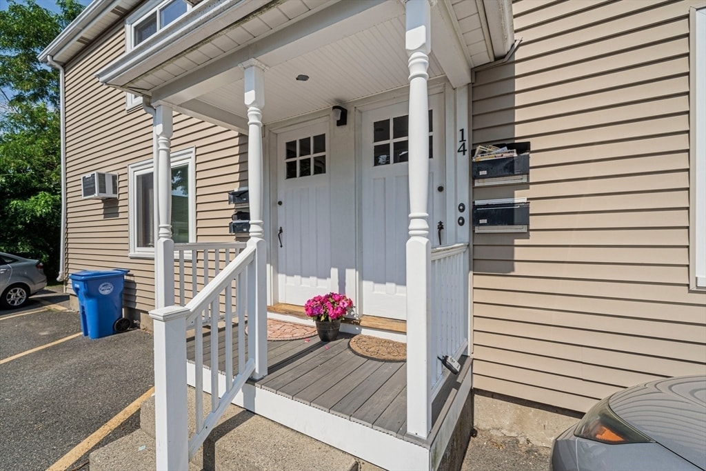
14 Hartwell St
14 Hartwell St
Waltham, MA 02453
2 Weeks Ago
Favorites
14 Hartwell St

Favorites
Check Back Soon for Upcoming Availability
| Beds | Baths | Average SF |
|---|---|---|
| 1 Bedroom 1 Bedroom 1 Br | 1 Bath 1 Bath 1 Ba | 671 SF |
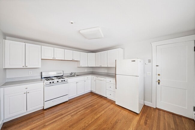
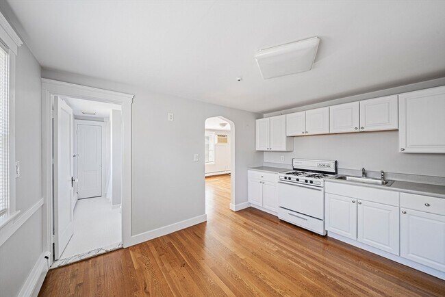
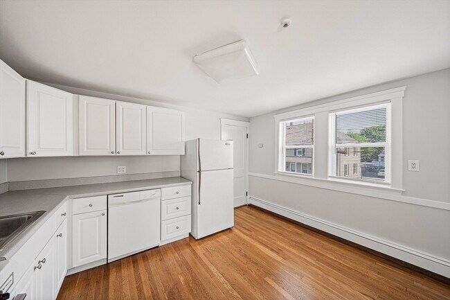
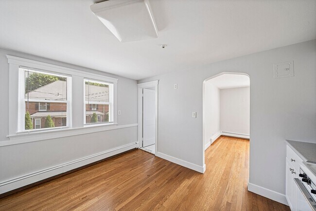
About This Property
This second-floor unit offers a perfect blend of comfort and convenience. Features include beautiful hardwood floors,gas cooking,a spacious eat-in kitchen and large bedroom. Laundry on property and one parking spot included for your convenience. Located just minutes from Brandeis University,major highways,and the train,this unit ensures easy accessibility to all your essential destinations. Enjoy the perfect combination of a cozy living space and a prime location.
14 Hartwell St is a townhome located in Middlesex County and the 02453 ZIP Code.
Location
Get Directions
Roberts is a quaint community on the Stony Brook Basin near Interstate 95, just two miles from Downtown Waltham. Only a few streets make up this neighborhood, so residents enjoy peace and quiet in their picturesque, long-standing homes. Several moderately priced apartments and condos are available for rent in the area as well. Public bus stops sit in the neighborhood, as well as the Brandeis/Roberts train MBTA station. Roberts is adjacent to Brandeis University, so locals enjoy access to university attractions and amenities like the Rose Art Museum. Although Roberts is closer to Waltham, residents can still commute to Boston, located roughly 14 miles east.
Learn more about living in RobertsBelow are rent ranges for similar nearby apartments
Education
| Colleges & Universities | Distance | ||
|---|---|---|---|
| Colleges & Universities | Distance | ||
| Walk: | 9 min | 0.5 mi | |
| Drive: | 8 min | 3.6 mi | |
| Drive: | 13 min | 6.3 mi | |
| Drive: | 14 min | 7.4 mi |
14 Hartwell St is within 9 minutes or 0.5 mile from Brandeis University. It is also near Bentley University and Babson College.
Transportation options available in Waltham include Riverside Station, located 3.1 miles from 14 Hartwell St. 14 Hartwell St is near General Edward Lawrence Logan International, located 16.7 miles or 26 minutes away, and Worcester Regional, located 38.8 miles or 55 minutes away.
| Transit / Subway | Distance | ||
|---|---|---|---|
| Transit / Subway | Distance | ||
|
|
Drive: | 6 min | 3.1 mi |
|
|
Drive: | 6 min | 3.4 mi |
|
|
Drive: | 8 min | 4.1 mi |
|
|
Drive: | 10 min | 5.7 mi |
|
|
Drive: | 10 min | 5.9 mi |
| Commuter Rail | Distance | ||
|---|---|---|---|
| Commuter Rail | Distance | ||
|
|
Walk: | 3 min | 0.2 mi |
|
|
Drive: | 4 min | 1.9 mi |
| Drive: | 4 min | 2.0 mi | |
|
|
Drive: | 6 min | 3.2 mi |
|
|
Drive: | 15 min | 8.3 mi |
| Airports | Distance | ||
|---|---|---|---|
| Airports | Distance | ||
|
General Edward Lawrence Logan International
|
Drive: | 26 min | 16.7 mi |
|
Worcester Regional
|
Drive: | 55 min | 38.8 mi |
Time and distance from 14 Hartwell St.
| Shopping Centers | Distance | ||
|---|---|---|---|
| Shopping Centers | Distance | ||
| Walk: | 2 min | 0.1 mi | |
| Drive: | 3 min | 1.6 mi | |
| Drive: | 6 min | 2.5 mi |
14 Hartwell St has 3 shopping centers within 2.5 miles, which is about a 6-minute walk. The miles and minutes will be for the farthest away property.
| Parks and Recreation | Distance | ||
|---|---|---|---|
| Parks and Recreation | Distance | ||
|
Land's Sake Farm
|
Drive: | 7 min | 3.7 mi |
|
Beaver Brook Reservation
|
Drive: | 8 min | 4.3 mi |
|
Hemlock Gorge Reservation
|
Drive: | 10 min | 5.5 mi |
|
Hamlen Woods
|
Drive: | 13 min | 6.3 mi |
|
Hazel Brook Conservation Area
|
Drive: | 16 min | 7.4 mi |
14 Hartwell St has 5 parks within 7.4 miles, including Land's Sake Farm, Beaver Brook Reservation, and Hemlock Gorge Reservation.
| Hospitals | Distance | ||
|---|---|---|---|
| Hospitals | Distance | ||
| Drive: | 2 min | 1.1 mi | |
| Drive: | 5 min | 3.1 mi | |
| Drive: | 9 min | 4.7 mi |
14 Hartwell St has 3 hospitals within 4.7 miles, the nearest is Walden Behavioral Care which is 1.1 miles away and a 2 minute drive.
| Military Bases | Distance | ||
|---|---|---|---|
| Military Bases | Distance | ||
| Drive: | 18 min | 9.3 mi | |
| Drive: | 17 min | 9.8 mi |
14 Hartwell St is 9.3 miles from Hanscom Air Force Base, and is convenient to other military bases, including US Military Reservation.
You May Also Like
-
Windsor Village at Waltham
976 Lexington St
Waltham, MA 02452
$2,695 - $6,450 Plus Fees
1-3 Br 3.6 mi
-
Avana Marlborough
20 Applebriar Ln
Marlborough, MA 01752
$2,325 - $17,713 Total Monthly Price
1-2 Br 17.2 mi
-
Windsor Ridge at Westborough
1 Windsor Ridge Dr
Westborough, MA 01581
$2,395 - $7,515 Plus Fees
1-3 Br 17.4 mi
Similar Rentals Nearby
-
-

-

-

-

-

-
 $1,275Total Monthly Price12 Month Lease4 Beds, 2 Baths, 2,000 sq ftTownhome for Rent
 -
 $3,600Total Monthly Price12 Month Lease3 Beds, 1.5 Baths, 1,350 sq ftTownhome for Rent
 -
 $1,100Total Monthly Price12 Month Lease1 Bed, 2 Baths, 1,750 sq ftTownhome for Rent
 -
 $3,200Total Monthly Price12 Month Lease3 Beds, 2.5 Baths, 1,488 sq ftTownhome for Rent
What Are Walk Score®, Transit Score®, and Bike Score® Ratings?
Walk Score® measures the walkability of any address. Transit Score® measures access to public transit. Bike Score® measures the bikeability of any address.
What is a Sound Score Rating?
A Sound Score Rating aggregates noise caused by vehicle traffic, airplane traffic and local sources
14 Hartwell St
Waltham, MA 02453