

$4,750
/ Month
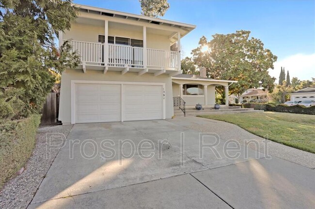
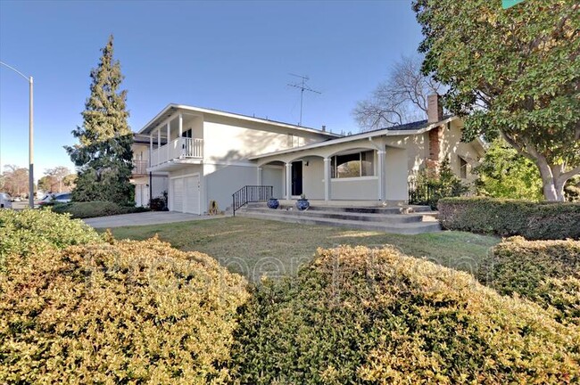
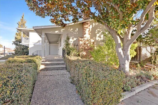
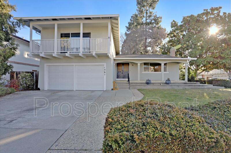
1398 Thunderbird Ave
Sunnyvale, CA 94087
2 Weeks Ago
|
Edit
Favorites
1398 Thunderbird Ave

Favorites
Check Back Soon for Upcoming Availability
| Beds | Baths | Average SF |
|---|---|---|
| 4 Bedrooms 4 Bedrooms 4 Br | 3 Baths 3 Baths 3 Ba | 2,295 SF |
About This Property
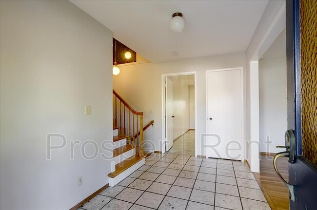
Charming 4BR/3BA home in Sunnyvale close to major businesses and schools. This home sits on a quiet street in the "Birdland Neighbors" area of Sunnyvale and provides easy access to many major freeways. Home features hardwood floors throughout, separate living room with fireplace.
1398 Thunderbird Ave is a house located in Santa Clara County and the 94087 ZIP Code. This area is served by the Santa Clara Unified School District attendance zone.
1398 Thunderbird Ave,
Sunnyvale,
CA
94087
Located in southeastern Sunnyvale, Raynor Park is a largely residential community teeming with apartments and houses available for rent. Raynor Park offers residents a tranquil home environment, along with quick access to local parks, schools, and area employers.
The community’s namesake park is a longstanding local favorite, offering dinosaur-themed play areas, picnic areas, horseshoe pits, and ample open space to enjoy the outdoors close to home. Raynor Park is also convenient to several other popular parks in the area, including Ortega Park, Ponderosa Park, and Santa Clara Central Park.
Raynor Park is within easy commuting distance of numerous area employers, including Apple Park headquarters, Santa Clara University, San Jose City College, Kaiser Permanente Santa Clara Medical Center, and Norman Y. Mineta San Jose International Airport.
Learn more about living in Raynor ParkBelow are rent ranges for similar nearby apartments
Education
| Colleges & Universities | Distance | ||
|---|---|---|---|
| Colleges & Universities | Distance | ||
| Drive: | 10 min | 4.1 mi | |
| Drive: | 12 min | 4.8 mi | |
| Drive: | 12 min | 6.3 mi | |
| Drive: | 14 min | 7.4 mi |
1398 Thunderbird Ave is within 10 minutes or 4.1 miles from Santa Clara University. It is also near De Anza College and San Jose City College.
Schools


Public Elementary School
Grades K-5
407 Students
Nearby
Public Elementary School
Grades K-5
571 Students
Attendance Zone
Public Middle School
Grades 6-8
759 Students
Attendance Zone
Public High School
Grades 9-12
1,614 Students
Attendance Zone
School data provided by
 The GreatSchools Rating helps parents compare schools within a state based on a variety of school quality indicators and provides a helpful picture of how effectively each school serves all of its students. Ratings are on a scale of 1 (below average) to 10 (above average) and can include test scores, college readiness, academic progress, advanced courses, equity, discipline and attendance data. We also advise parents to visit schools, consider other information on school performance and programs, and consider family needs as part of the school selection process.
View GreatSchools Rating Methodology
Data provided by GreatSchools.org © 2026. All rights reserved.
View GreatSchools Rating Methodology
Data provided by GreatSchools.org © 2026. All rights reserved.
Transportation options available in Sunnyvale include Vienna Station, located 4.2 miles from 1398 Thunderbird Ave. 1398 Thunderbird Ave is near Norman Y Mineta San Jose International, located 4.4 miles or 11 minutes away, and San Francisco International, located 31.9 miles or 41 minutes away.
| Transit / Subway | Distance | ||
|---|---|---|---|
| Transit / Subway | Distance | ||
| Drive: | 8 min | 4.2 mi | |
| Drive: | 8 min | 4.3 mi | |
| Drive: | 8 min | 4.5 mi | |
| Drive: | 9 min | 4.6 mi | |
| Drive: | 9 min | 4.8 mi |
| Commuter Rail | Distance | ||
|---|---|---|---|
| Commuter Rail | Distance | ||
| Drive: | 5 min | 2.3 mi | |
| Drive: | 8 min | 3.3 mi | |
| Drive: | 9 min | 3.9 mi | |
| Drive: | 9 min | 4.0 mi | |
| Drive: | 12 min | 6.8 mi |
| Airports | Distance | ||
|---|---|---|---|
| Airports | Distance | ||
|
Norman Y Mineta San Jose International
|
Drive: | 11 min | 4.4 mi |
|
San Francisco International
|
Drive: | 41 min | 31.9 mi |
Walkability Near 1398 Thunderbird Ave Sunnyvale, CA 94087
Getting Around
 What do Walkability, Transit, Drivability, and Bikeability mean?
Walkability measures the walking distance to day-to-day needs.
Transit measures access to public transportation.
Drivability measures congestion, parking availability, and access to major roads.
Bikeability measures the suitability for cycling.
How It Works
What do Walkability, Transit, Drivability, and Bikeability mean?
Walkability measures the walking distance to day-to-day needs.
Transit measures access to public transportation.
Drivability measures congestion, parking availability, and access to major roads.
Bikeability measures the suitability for cycling.
How It Works
Moderately Walkable
Walkability
60
/ 100
Limited Public Transit
Transit
30
/ 100
Very Drivable
Drivability
80
/ 100
Moderately Bikeable
Bikeability
60
/ 100
Scores provided by
-
Soundscore™
-
/ 100
Traffic
-Airport
-Businesses
-Scores provided by
HowLoud What is a Sound Score Rating? A Sound Score Rating aggregates noise caused by vehicle traffic, airplane traffic and local sources. How It WorksTime and distance from 1398 Thunderbird Ave.
| Shopping Centers | Distance | ||
|---|---|---|---|
| Shopping Centers | Distance | ||
| Walk: | 4 min | 0.3 mi | |
| Walk: | 8 min | 0.4 mi | |
| Walk: | 8 min | 0.5 mi |
1398 Thunderbird Ave has 3 shopping centers within 0.5 mile, which is about a 8-minute walk. The miles and minutes will be for the farthest away property.
| Parks and Recreation | Distance | ||
|---|---|---|---|
| Parks and Recreation | Distance | ||
|
Fujitsu Planetarium
|
Drive: | 12 min | 4.8 mi |
|
Sunnyvale Baylands Park
|
Drive: | 11 min | 5.1 mi |
|
Live Oak Park - Santa Clara
|
Drive: | 11 min | 5.9 mi |
|
Ulistac Natural Area
|
Drive: | 12 min | 6.4 mi |
|
McClellan Ranch Park
|
Drive: | 14 min | 6.9 mi |
1398 Thunderbird Ave has 5 parks within 6.9 miles, including Fujitsu Planetarium, Sunnyvale Baylands Park, and Live Oak Park - Santa Clara.
| Hospitals | Distance | ||
|---|---|---|---|
| Hospitals | Distance | ||
| Walk: | 19 min | 1.0 mi | |
| Drive: | 2 min | 1.2 mi | |
| Drive: | 12 min | 5.7 mi |
1398 Thunderbird Ave has 3 hospitals within 5.7 miles, the nearest is Kaiser Permanente Psychiatric Health Facility - Santa Clara which is 1.0 mile away and a 19 minute walk.
| Military Bases | Distance | ||
|---|---|---|---|
| Military Bases | Distance | ||
| Drive: | 16 min | 8.6 mi |
1398 Thunderbird Ave is 8.6 miles and a 16 minute drive from Ames Research Center.
You May Also Like
Similar Rentals Nearby


What Are Walk Score®, Transit Score®, and Bike Score® Ratings?
Walk Score® measures the walkability of any address. Transit Score® measures access to public transit. Bike Score® measures the bikeability of any address.
What is a Sound Score Rating?
A Sound Score Rating aggregates noise caused by vehicle traffic, airplane traffic and local sources.
1398 Thunderbird Ave
Sunnyvale, CA 94087